Discovering the Harmon Canyon Preserve in Ventura
Conservation is balanced with public recreation at the preserve tucked away into the hillsides off Highway 126
Source of this article: Noozhawk April 22, 2022
 Sometimes the best surprises come in tucked away places.
The drive up to the Harmon Canyon Preserve in Ventura is an easy one — it’s less than 10 minutes off Highway 126 on Kimball Road to the trailhead.
As you drive up to Harmon Canyon, it may seem a bit unimpressive and at first glance you’d think there isn’t much there to offer.
But it turns out to be a fascinating place to explore whether for an hour or so along the canyon riparian corridor or for an extended hike into its upper reaches.
Lima Beans and Cattle Grazing
The old farm road meandering up the canyon is six miles long, much longer than you would have thought from the trailhead.
A number of trails along the east side provide opportunities to get off the road and onto the single track.
Along the way you’ll spot remnants of rusted old equipment used for a bit of lima bean farming and cattle grazing for nearly a half-century. There also are remnants of a homestead of sorts along one of the trails.
Preserving for the Future, Sharing with the Public
The Harmon Canyon Preserve was purchased by the Ventura Land Trust in 2020 as part of its mission to permanently protect the land, water, wildlife and scenic beauty of the Ventura region.
Unlike many of the other open space areas in Ventura County, along with its preservationist values, the Land Trust has fully embraced the concept of public recreation at Harmon Canyon.
“We’re a conservation organization. Protecting and preserving wildlife habitat is our No. 1 priority,” preserve Director Dan Hulst said. “But we also understand and I think it’s critical that we also connect our community to open spaces like this.”
Those at the Ventura Land Trust appear to understand an important concept that other open space organizations such as The Nature Conservancy seem to miss: providing opportunities to recreate and creating connections to the land are critical to conservation as a whole.

A view of what will be Trail 203. It is under construction. Note that the route leads up the upper east hillsides and over the next ridge. (Ray Ford photo)
Building Trails for the Future
Given that the preserve is barely two years old, there are already quite a few single track trails open for hikers, trail runners and mountain bikers to use.
These are clustered on the east side of the lower canyon, the first of a planned set of trails that will encompass the entire preserve in the next few years.
“In the last eight months, we’ve built about four miles of trail,” Hulst said. “We have a conceptual plan for the property with development of additional trails laid out three phases. Each phase involves about 10 miles of new trail construction.”
I’m thinking, that means 30 miles of new trail opportunities. That’s close to as many trail miles as there are in the entire Santa Barbara frontcountry!
Currently, most of the trails in the first phase have been completed. Work is now being done to finish construction on a 2.5-mile section that will tie into the upper canyon and eventually the Phase 2 trails planned for constructionally next year.
Local Trails Group Heading the Work
The trail construction is being overseen by Santa Barbara-based Sage Trail Alliance.
“The project was perfect for Sage,” said Dillon Osleger, executive director for the group.
Previously known as the Santa Barbara Mountain Bike Trail Volunteers, the group made the decision to widen its focus to include other trail user interests, including hikers and trail runners.
“Along with supporting these other groups,” Osleger said, “we also wanted to be more involved with environmental restoration and educational programs.”
That was exactly what the preserve was looking for.
Collaborative Restoration
Along with the Sage’s major role as the trail construction contractor for the Harmon Canyon Preserve, Hulst and Osleger have been conducting regular volunteer work projects.
“Winter and spring are busy months,” Hulst said. “On average, Dan and I are coordinating three or four volunteer projects a month.”
Saturdays are usually “dirt days,” Osleger added. “Sundays are what we call invasive species days, with docents provided by the preserve and some of the Sage crew.”

A mid-canyon section of Harmon Canyon Road a mile from the trailhead. (Ray Ford photo)
On the Trail
It’s a beautiful Friday afternoon. Low 70-degree temps, a light breeze and lush hillsides that radiate greenness.
The oaks are particularly spectacular, many of them well along in age limbs at the point where they’re beginning droop a bit, giving them a character I love.
Amazingly, many of them have been able to survive the Thomas Fire.
“The property burned in totality during the fire,” Hulst recalled. “But fortunately, it burned through at different speeds and different heat levels.”
That may have helped save many of those I’ve been enjoying as I head up the canyon.
Fork in the Road
A third of a mile from the trailhead and just after the first creek crossing, Trail 102 leads off to the east. Road or trail — which should I take? Most seem to prefer the road. Some the trail.
Taking the road is simple, so I decide to continue along it for now and take the eastside trails back down. Easy peasy.
From this point it’s 1.3 miles up to the point where the trails will loop you back down and about 1.6 along them. After the first 10 minutes on the trail I’ve hooked. The return trip back via single track is well worth it. In the spring, riparian scenery is spectacular; the oak forests are enchanting and the ruins of the old Walker family homestead are an additional treat.
Give me nature, not dirt roads.
For first time visitors, a caution: It’s easy to get confused given the number of connected trails leading back over to the road. Best to have a photo of the preserve map on your phone and refer to it often.
Farr Family Trail
Trail bonus: Should you take the Price Family Trail on the way back, a few hundred yards along it look for a trail spitting off to the left that begins to switch back and forth uphill.
This is the Farr Family Trail, a 1.7-mile loop that leads steeply up to the east crest, then follows that for a half-mile before descending back down to join Trail 105 near the Walker homestead.
The hike will leave you breathless. It’s possible because of the strenuous climbing it will take you to get to the ridgetop; but most likely, the views across the entire Santa Clara River valley and southward to Point Mugu will be the cause. Unbelievable.
Upper Canyon Hiking
Power hikers, cyclists and trail runners will want to continue up the ranch road to the upper canyon. A number of road options that lead to high points with views equal to that are along the Farr Family Trail.
Unfortunately, at present there are no trails in the upper canyon though that will change in the next few years as the Sage Trail Alliance continues to complete additional trail segments in Phases 2 and 3.
You should know that dogs are not permitted in the upper canyon in case you do decide to continue on.
For those who continue on, it is another 0.8 miles to the end of the canyon and the beginning of some intense climbing. To the east leads to a high point along the Long Canyon Road and the preserve boundary; north takes you up to another view point at the top of the Harmon Canyon Road; and the third up the West Road to the ridge.
All provide intense workouts, wondrous views and, unfortunately, are all out-and-backs.
Don’t hesitate to check out Harmon Canyon. The flowers and green grasses won’t last much longer.
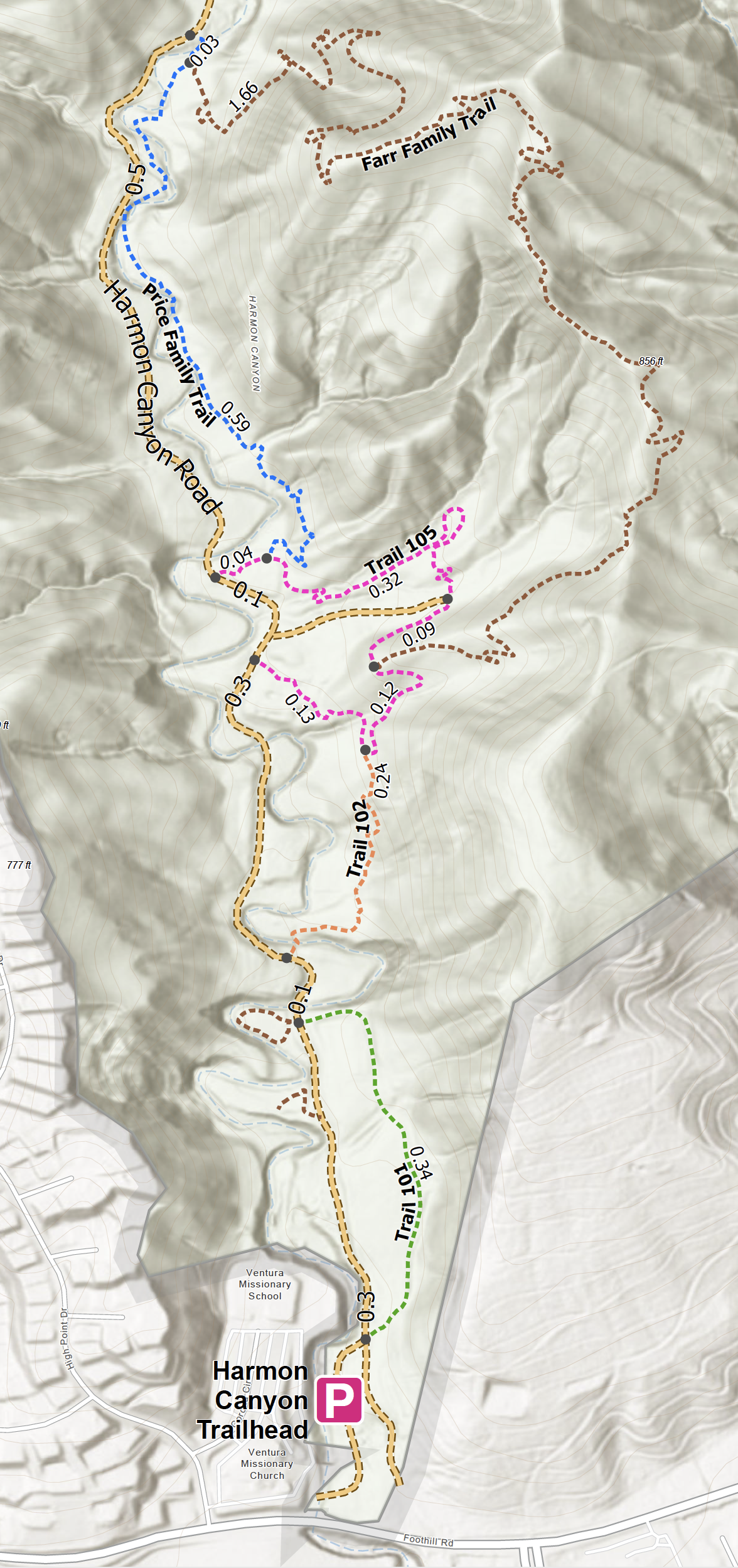
Map of the lower trail system at Harmon Canyon. (Harmon Canyon Preserve photo)

0 Comments