|
Trails of
Oak Park
Overview
of adjacent areas
|
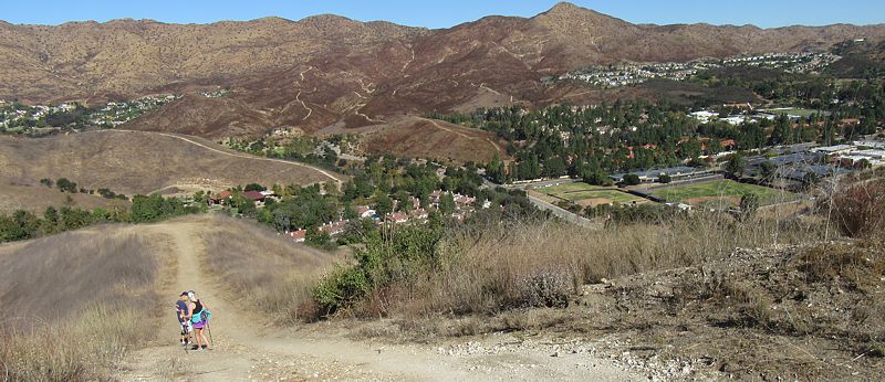
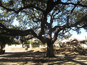
Looking
north from the Wistful Vista Trail in the Wistful Vista Open Space
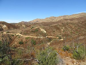
Oak Park is blessed with lots of trails, most of which share a few characteristics: broad, steep, shadeless and provide great views once you get a little elevation under your belt. Many of the trails are too steep for a regular mountain bike, particularly the Wistful Vista Trails, but they're wonderful if you're looking for a conditioning hike or run! Rather then indulging in switchbacks or climbing turns, the trails tend to go straight up the hill to the top of a ridge.
The Oak Park trails are managed and maintained by the Rancho Simi Recreation and Park District. The trails are all quite broad - about wide enough for a single vehicle. There are no singletrack trails here. They also have a pretty even tread, and mostly firm. My guess is that they run a vehicle with a blade along them from time to time.
An exception are the Medea Creek Trails. Most segments are paved, and the hills are barely noticable.
An unusual characteristic is that the trails are named after the open space they occupy. There are always multiple forks to the trails, but the legs don't have distinct names. An example is the Wistful Vista Trail. It has eight trailheads on different segments, but they all have the same name. On maps here, I've added segment names for the various arms and legs to distinguish them.
|
|

Trailheads, Parking and Features
a. Ridgeway Drive. Map
and directions
b. Bayport Way. Map
and directions
c. Rockfield Street. Map
and directions
d. Golden Nugget Way. Map
and directions
e. Golden Eagle Drive. Map
and directions
f. Falling Star Avenue. Map
and directions
g. Lindero Canyon Road for Rock Ridge Trail. There is no parking here.
Map
and directions
g. Lindero Canyon Road for Canyon Cove Trail. Check for No Parking signs.
Map
and directions
h. Pathfinder Avenue. Map
and directions
I. Bromely Drive. Map
and directions
j. Burano Court. Map
and directions
k. Kanan Road for Wistful Vista access. Check for
No Parking signs. Map
and directions
k. Kanan Road for Medea Creek and Sunrise Meadow
Creekside Trails access. Check for No Parking signs. Map
and directions
l. Oak Hills Drive. Map
and directions
m. Conifer Street. There is no parking here. Map
and directions
n. Fountainwood Street. Map
and directions
o. Deerhill Road. Map
and directions
p. Doubletree Road . Map
and directions, and a little
further south-east
q. Oak Point Drive. Map
and directions
r. Sunnycrest Drive. Map
and directions
s. Smoke Tree Avenue for access to the Sunrise
Meadow Ridge Trail. Map
and directions
s. Smoke Tree Avenue for access to the Smoke Tree
Connector to Palo Comado. Map
and directions
t. Perigrine Circle. Map
and directions. Map
and directions
v. Oak Park High School
w. Trail possibly blocked by stream
debris
x. Oak Canyon Community Park
y. Oak Park Community
Center and Gardens
z. Indian Springs Park
![]() Water
tank
Water
tank![]() Locked
gate
Locked
gate
Download the GPS tracks ![]() to help you find your way. This GPX file contains tracks for all the trails
in this area.
to help you find your way. This GPX file contains tracks for all the trails
in this area.
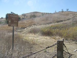
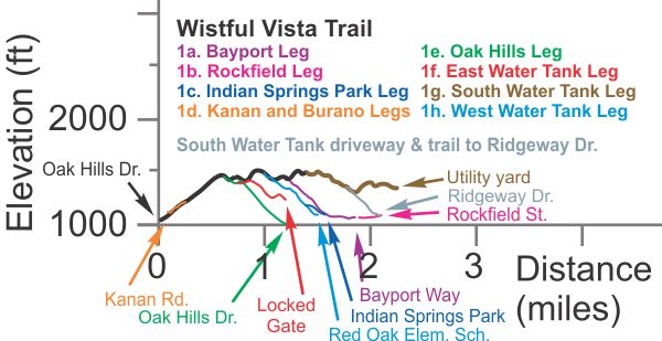
[1] Wistful Vista
Trail T2.5
![]() because it's so steep, otherwise T1
because it's so steep, otherwise T1
![]()
[1a]
Wistful Vista, Bayport Leg T2.5
![]()
[1b]
Wistful Vista, Rockfield Leg T2.5
[1c] Wistful Vista, Indian
Springs Park Leg T1.5
![]()
[1d]
Wistful Vista, Kanan and Burano Legs T3
![]() because of stairs
because of stairs
[1e] Wistful Vista, Oak Hills
Leg T3
![]() because of a loose and crazy steep section
because of a loose and crazy steep section
[1f]
Wistful Vista, East Water Tank Leg T2.5
![]()
[1g] Wistful
Vista, South Water Tank Leg T2
![]()
[1h] Wistful
Vista, West Water Tank Leg T4
![]() with a loose rocky rutted singletrack
with a loose rocky rutted singletrack
 Description The
Wistful Vista Open Space encompasses a dramatic ridge in the middle of Oak Park.
The trail has multiple legs that fork off from the main trail to descend to
eight trailheads that provide easy access from many neighborhoods. The elevation
profile below is very complicated because of all these legs that start at the
street and climb up to the trail along the top of the ridge. One thing they
all have in common is that they go straight up the hill and are very steep!
Once to the top, however, the view is spectacular in all or most directions.
There are several hilltops along the main trail, so the steep hills don't
stop once you get to the top, and all the hilltops have great views.
Description The
Wistful Vista Open Space encompasses a dramatic ridge in the middle of Oak Park.
The trail has multiple legs that fork off from the main trail to descend to
eight trailheads that provide easy access from many neighborhoods. The elevation
profile below is very complicated because of all these legs that start at the
street and climb up to the trail along the top of the ridge. One thing they
all have in common is that they go straight up the hill and are very steep!
Once to the top, however, the view is spectacular in all or most directions.
There are several hilltops along the main trail, so the steep hills don't
stop once you get to the top, and all the hilltops have great views.
The trails are much too steep to climb on a regular mountain bike.
All these trails are narrow dirt roads or wide paths. Mostly they're firm and fairly even, but there are some loose spots on some of the steeper sections. The photo to right shows the ridgeline trail from along the East Water Tank Leg, looking north-west towards the main trail. The banner photo at the top of this page shows the view looking north from the northernmost peak.
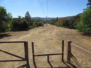
1 Wistful Vista Trail: T2.5
![]() This main trail runs from Oak Hills Drive, up the steep hill along the ridgeline,
ending where 1a forks off from it. At the time of this writing (July 2020),
the trail was blocked by heavy vegetation near the north-west end where
it crosses a stream. Hikers may be able to worm their way through. And the park
district could clear out the blockage at any time.
This main trail runs from Oak Hills Drive, up the steep hill along the ridgeline,
ending where 1a forks off from it. At the time of this writing (July 2020),
the trail was blocked by heavy vegetation near the north-west end where
it crosses a stream. Hikers may be able to worm their way through. And the park
district could clear out the blockage at any time.
1a Bayport Leg: 0.6 miles long, 400 feet of climbing
T2.5
![]() . This
segments ends on Bayport Way, only a quarter block from the east end of the
short 400 yard-long Rockfield Leg, 1b. It's easy to combine these
two segments into one route.
. This
segments ends on Bayport Way, only a quarter block from the east end of the
short 400 yard-long Rockfield Leg, 1b. It's easy to combine these
two segments into one route.
1c Indian Springs Park Leg: 300 yards long, 80' of climbing
T1.5
![]() .
This segment starts at the east edge of Indian Springs Park and climbs less
steeply than 1h West Water Tank Leg to which it connects.
.
This segment starts at the east edge of Indian Springs Park and climbs less
steeply than 1h West Water Tank Leg to which it connects.
 1d
Kanan and Burano Legs: T3
1d
Kanan and Burano Legs: T3
![]() This represents 3 short spurs, two of which come out on Kanan Rd and one on
Burano Ct. The Burnano and western Kanan spurs are steep enough to start with
steps from the trailheads. The eastern Kanan trailhead is not steep at all at
the start as shown in the photo at right.
This represents 3 short spurs, two of which come out on Kanan Rd and one on
Burano Ct. The Burnano and western Kanan spurs are steep enough to start with
steps from the trailheads. The eastern Kanan trailhead is not steep at all at
the start as shown in the photo at right.
1e Oak Hills Leg: 0.45 miles long, 400' of climbing T3
![]() .
This trail has a very loose and crazy steep section about 40% of the way up
from the bottom.
.
This trail has a very loose and crazy steep section about 40% of the way up
from the bottom.
1f East Water Tank Leg: 0.6 miles long, 250' of descent
from the main trail T2.5
![]() .
This dogleg trail leads to a cell tower site and a paved driveway to a water
tank. However, there is a locked gate to keep you from getting out to the street.
There is a loose section towards the bottom before you reach the paved part.
.
This dogleg trail leads to a cell tower site and a paved driveway to a water
tank. However, there is a locked gate to keep you from getting out to the street.
There is a loose section towards the bottom before you reach the paved part.
1g South Water Tank Leg: 1.1 miles long T2
![]() .
The official trail seems to end where it joins 1a, the Bayport Leg, but in fact
it continues south across the border from Ventura County into LA County
as segment 1g. It narrows to a singletrack when it gets to the South Water Tank,
then continues beside the paved driveway before joining another dirt road that
forks off to the south. That segment ends at some sort of utility yard; there
is no access to the street from there. If you continue down the paved driveway,
it's blocked by a locked gate, but there is a short trail beside a concrete
V-ditch that comes out to Ridgeway Drive.
.
The official trail seems to end where it joins 1a, the Bayport Leg, but in fact
it continues south across the border from Ventura County into LA County
as segment 1g. It narrows to a singletrack when it gets to the South Water Tank,
then continues beside the paved driveway before joining another dirt road that
forks off to the south. That segment ends at some sort of utility yard; there
is no access to the street from there. If you continue down the paved driveway,
it's blocked by a locked gate, but there is a short trail beside a concrete
V-ditch that comes out to Ridgeway Drive.
1h West Water Tank Leg: 0.5 miles long, 400' of climbing
T4
![]() .
This segment starts from the main trail as a narrow dirt road but narrows to
a singletrack as it rounds the water tank, parallels the paved driveway for
a bit, then turns downhill. This section is rocky, loose and rutted. When 1c
Indian Springs Park Leg forks off, 1h gets even steeper and more loose!
It comes out at an elementary school.
.
This segment starts from the main trail as a narrow dirt road but narrows to
a singletrack as it rounds the water tank, parallels the paved driveway for
a bit, then turns downhill. This section is rocky, loose and rutted. When 1c
Indian Springs Park Leg forks off, 1h gets even steeper and more loose!
It comes out at an elementary school.
Trail Profile Back to the Top
 [2]
Lindero Canyon Trail T1.5
[2]
Lindero Canyon Trail T1.5
![]() ,
T0.5
,
T0.5
![]()
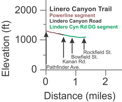
Description This trail has three segments. At the north is an Edison road below powerlines; at the south is a decomposed granite (DG) pathway a few feet west of Lindero Canyon Road. To connect these, you need to travel on the sidewalk along Lindero Canyon Road for about 330 yards.
The powerline segment T1.5
![]() is a narrow dirt road and a little
uneven. It is only 0.4 miles long, with a very gentle grade
dropping 100 feet when going south from Pathfinder Avenue where the trail terminates.
Across the street, the Sandstone Hills Trail starts. The upper photo shows the trail
looking south from Pathfinder Ave.
is a narrow dirt road and a little
uneven. It is only 0.4 miles long, with a very gentle grade
dropping 100 feet when going south from Pathfinder Avenue where the trail terminates.
Across the street, the Sandstone Hills Trail starts. The upper photo shows the trail
looking south from Pathfinder Ave.
 The
DG path next to Lindero Canyon Road has a very gradual slope and a very
even tread T0.5
The
DG path next to Lindero Canyon Road has a very gradual slope and a very
even tread T0.5
![]() .
From Kanan Road south to Rockfield Street the path is about 3.5' wide. South
of Rockfield, the trail moves away from the street a bit and expands in width
to that of a road. It ends abruptly about 180 yards south of Rockfield.
.
From Kanan Road south to Rockfield Street the path is about 3.5' wide. South
of Rockfield, the trail moves away from the street a bit and expands in width
to that of a road. It ends abruptly about 180 yards south of Rockfield.
|
Length (miles) |
1.4; the powerline segment is 0.4 miles long |
|
Climb (feet) |
20 (traveling south) |
|
Descent (feet) |
230 |
[2a] Lindero Creek Trail This very pretty
trail is described on the North Ranch
map page T0.5
![]() T2
T2
![]() .
.
Trail Profile. Back to the Top
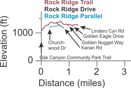
[3] Rock Ridge Trail
T2.5
![]() ,
T1.5
,
T1.5
![]()
[3a]
Rock Ridge Drive T0
![]()
[3b]
Rock Ridge Parallel T1.5
![]()
Description Rock Ridge Trail starts off at the east end branching off from the Oak Canyon Community Park Trail with an increadibly steep climb out of the canyon to a ridgeline. Another trail, not shown on the map, climbs out of the Oak Park Community Center parking lot and it is at least as steep. The steepest sections of this trail are a little loose, but the rest is pretty firm. Because of the steepness, the southwest third of the trail rates T2.5. Otherwise it would probably be T1.
The trail is good for building up your leg muscles, but if you're on a bike, be prepared to push it.
The western-most half mile is hilly with much gentler slopes,
so it rates T1.5
![]() .
There are two spurs in this section that lead to neighborhood streets, so the
access from the west end is much easier. However, there is no parking on
Lindero Canyon Road at the western terminus.
.
There are two spurs in this section that lead to neighborhood streets, so the
access from the west end is much easier. However, there is no parking on
Lindero Canyon Road at the western terminus.
3a Rock Ridge Drive: 0.25 miles long with 185 feet of
climbing. This is a very steep concrete road from Kanan up to an underground
water tank along the Rock Ridge Trail. T0
![]()
3b Rock Ridge Parallel: 0.34 miles long with 115' of
climbing and 20' of descent. This trail leads from Churchwood Drive to
about the midpoint of Rock Ridge Drive. It is the typical 1-vehicle wide and
the tread is in very good shape. It starts with a moderately steep climb but
shortly becomes more gentle. Overall it's much less steep that Rock Ridge Drive.
T1.5
![]()
|
Length (miles) |
1.3 (main trail without neighborhood spurs) |
|
Climb (feet) |
420 (going east to west) |
|
Descent (feet) |
220 |
Trail Profile Back to the Top
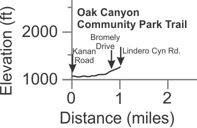
[4] Oak Canyon
Community Park Trail T1
![]()
Description This is a narrow dirt road that winds through the trees near the creek in Oak Canyon. You can start at the Community Park on Kanan Road and continue to Bromely Drive. There is a very gentle grade uphill that gets quite a bit steeper as you approach Bromely Drive. It's very popular and pretty with lots of shade. It crosses the creek a couple of times, so it may be hard to pass when it's rainy, and will probably be muddy as well. There is a parallel paved road to the east and up the hill away from the creek that would be prefereable when it's wet.
The trail continues north beyond Bromely Drive as a singletrack
that starts at the eastern edge of the Eagle View Park. It continues about 230
yards to Lindero Canyon Road, across the street from the beginning of the
China Flat Trail. It's
a bit steeper and the tread is a little uneven so it rates at T2.5
![]()
|
Length (miles) |
1.0 from Kanan Rd to Lindero Canyon Rd. |
|
Climb (feet) |
200 |
|
Descent (feet) |
10 |
Trail Profile Back to the Top
[5] Rock Ridge Trail
(East) T2
![]() mostly but T2.5
mostly but T2.5
![]() where it crosses Medea Creek because of steepness
where it crosses Medea Creek because of steepness
[5a]
Rock Ridge (East), Doubletree Leg T2
![]()
 Description Like
most of the other trails in Oak Park, the trails in the Rock Ridge Open Space
(East) open space are single lane dirt roads, but these ones are a little looser
that others. The main trail starts on Hollytree Drive and ends at a cul-de-sac
on Deerhill Road. You can park on Hollytree or at the nearby Oak Canyon Community
Park. The main trail has 3 sections. The north-south section just
west of Medea Creek has moderate slopes. The next section where the trail
turns abruptly to the east and crosses Medea Creek is very very steep,
both going down and up. In climbing out of Medea creek, the trails gains 220'
in elevation with a fairly constant grade of 20 to 25%. That's much too steep
to ride a standard mountain bike up. The last section again has only moderatly
steep grades and ends at Deerhill Road.
Description Like
most of the other trails in Oak Park, the trails in the Rock Ridge Open Space
(East) open space are single lane dirt roads, but these ones are a little looser
that others. The main trail starts on Hollytree Drive and ends at a cul-de-sac
on Deerhill Road. You can park on Hollytree or at the nearby Oak Canyon Community
Park. The main trail has 3 sections. The north-south section just
west of Medea Creek has moderate slopes. The next section where the trail
turns abruptly to the east and crosses Medea Creek is very very steep,
both going down and up. In climbing out of Medea creek, the trails gains 220'
in elevation with a fairly constant grade of 20 to 25%. That's much too steep
to ride a standard mountain bike up. The last section again has only moderatly
steep grades and ends at Deerhill Road.
There's a great view from this hillside! You can easily see all the way south to the Santa Monica Mountains when the air is clear.
There are two short spurs, both on the western segment of the main trail. One leads to the paved drive in Oak Canyon Community Park, and the other leads to Suicide Trail.
5a Doubletree Leg: 0.8 miles long with 330' of climbing
and 70' of descent when heading northT2
![]() . Like the main trail, the tread is a little loose and it has some very steep
sections, but they're pretty short. The photo shows part of this trail climbing
up to the main trail.
. Like the main trail, the tread is a little loose and it has some very steep
sections, but they're pretty short. The photo shows part of this trail climbing
up to the main trail.
Technical Rating T2
![]() mostly but T2.5
mostly but T2.5
![]() where it's really steep
where it's really steep
|
Length (miles) |
1.3 |
|
Climb (feet) |
480, starting at Hollytree Drive |
|
Descent (feet) |
210 |
Trail Profile Back to the Top

 [6]
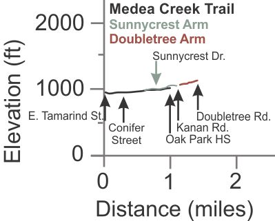
Medea Creek Trail T0
[6]
Medea Creek Trail T0
![]() ,
T1
,
T1
![]()
[6a]
Medea Creek, Sunnycrest Arm T0
![]()
[6b]
Medea Creek, Doubletree Arm T1
![]()
Description This very pretty and popular set of
trails is mostly a single-lane width paved trail T0
![]() with a few exceptions noted below. The grades are all gentle and there
are lots of oak trees around to provide shade. The west arm [6] follows
along Medea Creek. The trails go through a strip of parkland next to the creek
and behind neighborhood houses. There are lots of access points from neighborhood
streets - too many to show on the map.
with a few exceptions noted below. The grades are all gentle and there
are lots of oak trees around to provide shade. The west arm [6] follows
along Medea Creek. The trails go through a strip of parkland next to the creek
and behind neighborhood houses. There are lots of access points from neighborhood
streets - too many to show on the map.
 The
main Medea Creek Trail has Oak Park High School at the north terminus and East
Tamarind Street at the south. However, the trail continues as a 300-yard-long
singletrack through the grass from East Tamarind Street south to Fountainwood
Street. This southernmost section is shown on the map but is not included in
the elevation profile below. The photo to the left shows this segment.
The
main Medea Creek Trail has Oak Park High School at the north terminus and East
Tamarind Street at the south. However, the trail continues as a 300-yard-long
singletrack through the grass from East Tamarind Street south to Fountainwood
Street. This southernmost section is shown on the map but is not included in
the elevation profile below. The photo to the left shows this segment.
The section between Oak Hills Drive and East Tamarind Street
has two parallel trails on opposite sides of the creek. One trail is paved T0
![]() and
the other is single-lane-wide gravel or dirt T1
and
the other is single-lane-wide gravel or dirt T1
![]() .
.
6a Sunnycrest Arm: Somewhere near the middle, this arm forks off towards the north-east. It crosses Sunnycrest Drive and ends at Kanan Road across from Deerhill Road, covering 860 yeards and gaining about 80' in elevation. From Kanan, the Doubletree Arm 6b continues about 250' to the north-west, and the Sunrise Meadow Creekside Trail starts about 140' to the southeast.
6b Doubletree Arm: 0.25 miles long with 70' of climbing
from Kanan to Doubletree T1
![]() .
This single-lane dirt road is partly shaded by oak trees.
.
This single-lane dirt road is partly shaded by oak trees.
Trail Profile Back to the Top
[7] Sunrise
Meadow Creekside Trail T1.5
![]() has a short but very steep hill
has a short but very steep hill
[7a] Sunrise Meadow
Creekside, Sunnycrest Leg T1
![]()
[7b]
Sunrise Meadow Creekside, Doubletree Leg T1
![]()
Description The main trail starts at Doubletree Rd and ends at Kanan Rd. It is very pretty, the first 2/3 is under an oak canopy and the rest is in a meadow. It is 0.67 miles long with 240 feet of cummulative descent and 80 feet of climbing. Most of that climbing is on a short but very steep hill where the trail rounds a bend and turns northwest. It is equally steep on both sides of the hill, going up and down. There is a short singletrack spur (120 yards long with 45' of climbing) that leads from the main trail to a trail head on Oak Point Drive.
7a Sunnycrest Leg: 210 yards long with 65' of descent
T1
![]() .
This short spur drops from the main trail to Sunnycrest Drive with a gentle
slope.
.
This short spur drops from the main trail to Sunnycrest Drive with a gentle
slope.
7b Doubletree Leg: One third mile long with 110' of climbing.
This gently sloping trail connects to Doubletree Road from near the bottom (Kanan)
end of the main trail. The tread is firm and fairly even. There is no shade.
T1
![]()
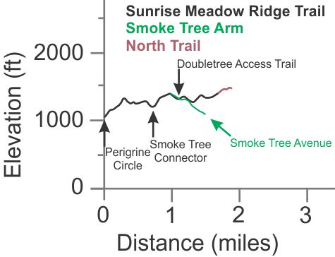
 [8] Sunrise Meadow
Ridge Trail T1
[8] Sunrise Meadow
Ridge Trail T1
![]() but possibly T2
but possibly T2
![]() because of the steepness
because of the steepness
[8a] Sunrise Meadow Ridge, Smoke Tree Arm
T1
![]() or T2
or T2
![]()
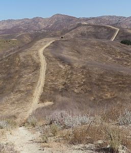
Description Most of the Sunrise Meadow Ridge Trail runs north-south, just outside (west of the boundary) of the Palo Comado open space. Like most trails in Oak Park, it is the width of a narrow single-lane road, is fairly firm and even, and is very steep. This is another good trail for a conditioning workout. The photo to the right shows the trail from near the south end, looking north. As you can see, there's no shade here, nor on the connecting trails that lead down to the Oak Park neighborhoods. At the north end, the "North Trail" is an unofficial trail that narrows to a singletrack and continues up an even steeper hill for 330 yards.
The Smoke Tree Arm leads west from the main trail for a half mile and ends at Smoke Tree Avenue. It is even steeper than most of the main trail
The main trail can also be accessed from the Doubletree Access Trail and the Smoke Tree Connector that join Oak Park and Palo Comado Canyon Road. These trails cross Sunrise Meadow Ridge Trail at low spots.
Technical Rating T1
![]() ,
or T2
,
or T2
![]() because of steepness
because of steepness
|
Length (miles) |
1.6; 1.75 to the end of the North Trail |
|
Climb (feet) |
700 (south to north); 750 to the end of the North Trail |
|
Descent (feet) |
320 (south to north); 320 to the end of the North Trail |
Trail Profile Back to the Top
[9] Doubletree Access
Trail T2
![]()
Description This trail provides access to Palo Comado Canyon from Oak Park, starting at Doubletree Road, and is less hilly than Smoke Tree Connector. It's a narrow dirt road with some minor ruts and a little loose gravel in places. To get to China Flat, this is the easiest place to start. It's too short to show an elevation profile.
Technical Rating T1.5
![]()
|
Length (miles) |
0.45 |
|
Climb (feet) |
85 (from Smoke Tree Ave to Palo Comado Canyon) |
|
Descent (feet) |
90 |
[10] Smoke Tree Connector
T1
![]()
Description This is a hilly double-track trail to access Palo Comado Canyon from Smoke Tree Ave. in Oak Park. It's too short to show an elevation profile.
Technical Rating T1
![]()
|
Length (miles) |
0.5 |
|
Climb (feet) |
140 (from Doubletree Road to Palo Comado Canyon) |
|
Descent (feet) |
75 |
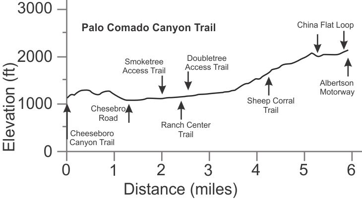
[11] Palo Comado Canyon Trail T2
![]()
Description The Palo Comado Canyon Trail is a fire road that starts in Cheeseboro Canyon, crosses over the ridge to Palo Comado Canyon, then climbs all the way to Albertson Motorway. There are two short connector trails to Oak Park. Palo Comado is the most common way to access China Flat. For more info on this trail, view its description on the Cheeseboro, Palo Comado and Las Virgenes Canyons page.
Technical Rating T2
![]()
|
Length (miles) |
5.9 |
|
Climb (feet) |
1500 |
|
Descent (feet) |
500 |
Trail Profile Back to the Top
 [12] Canyon
Cove Trail T1.5
[12] Canyon
Cove Trail T1.5
![]()
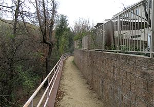
Description This very pretty singletrack wide trail passes behind a group of houses on Lindero Canyon Rd and next to Lindero Creek. There are lots of trees on the east (creek) side of the trail. The trail is only about a third of a mile long, but there's almost no slope to it, and the decomposed granite tread is firm and in really good shape. If the trail were wider, it would rate a T1 or maybe even T0.5. The beginning and end have a railing on the downhill side as seen in the photo because it's quite steep down to the creek there, but mostly there's no railing. The trail is too short to provide an elevation profile.
Technical Rating T1.5
![]()
|
Length (miles) |
0.36 |
|
Climb (feet) |
23 (travelling north to south) |
|
Descent (feet) |
28 |
This page was last updated February 26, 2021
|
|
Thanks for looking at Steve's guide to trails in Ventura County, the Santa Monica Mountains National Recreation Area (SMMNRA) and other locations. |
|