Trails of
Cheeseboro, Palo Comado and Las Virgenes Canyons
Overview
of adjacent areas

Cheeseboro
Canyon in the spring, when the mustard colors the hillsides bright yellow.
This area is extremely popular for hikers, mountain bikers and equestrians. A number of loop routes can be constructed of various lengths and amounts of climbing with Cheeseboro Ridge, Palo Comado Canyon Road, East Las Virgenes Canyon Trail and several connecting trails. Trails also lead to Oak Park and Ahmanson Ranch, further expanding the terrain that can be covered. From China Flat there is access to Thousand Oaks and Simi Valley trail systems.
Cheeseboro Canyon is pretty all year round, and in the spring is graced with bright yellow mustard on the hillsides, growing right up to the edge of the road and even into it. The canyon has many oak trees, growing quite densely in some spots and providing welcome shade. There are great views from the ridge routes. Of the three canyons, Cheeseboro is by far the prettiest.
There is lots of parking at the base of Cheeseboro Canyon with two parking areas, but even so, sometimes on the weekend it's hard to find a place to park. If the lower paved lot is full, keep going to the upper dirt lot. If it's full, head back down the drive and park perpendicular at the side. On Chesebro road, pay attention to the No Parking signs because it's easy to get a ticket.
The names of the trails in Las Virgenes Canyon are hard to pin down because three official maps from two land agencies show different names for them. Your correspondent has chosen the ones that seem to make the most sense.
Weather and Seasons Many of these trails quickly become severly overgrown in the spring, especially with mustard, and even the dirt roads can narrow down considerably. In the span of a week, the amount of overgrowth can increase a huge amount. Take this into consideration when planning your route in the spring! In the summer it can get very hot, and after it rains in the winter, the trails are goopy sticky mud that's practically impossible to clean off. It's best not to visit until several days after a rain, nor on a hot day. Check the weather forecast before you visit!
Watch the Seasons of Cheeseboro video to see what the area looks like at various times of the year.
|
|
Trailheads, Parking and Features
a. Main parking areas, just off Chesebro Rd. There is a lower and
upper lot. Map
and directions
b. North end of Las Virgenes Rd. You can park at
the side of the street. Map
and directions
c. Smoke Tree Avenue in Oak Park. You can
park at the side of the street. Map
and directions
d. Doubletree Road in Oak Park. You can park
at the side of the street. Map
and directions
e. Zev Yaroslavsky Las Virgenes Highlands Park.
Map
and directions
t. Future wildlife crossing bridge
u. Palo Comado Overlook
v. Zev Yaroslavsky Overlook
W. "Poison Oak" rock
x. Sheppard's Flat
y.
Calabasas Landfill
z. China Flat
Download the GPS tracks ![]() to help you find your way. This GPX file contains tracks for all the trails
in this area.
to help you find your way. This GPX file contains tracks for all the trails
in this area.
[1] Cheeseboro
Canyon Trail (AKA Sulphur Springs) T1
![]() ,
T3
,
T3
![]()
[1b]
Lower Cheeseboro Canyon Trail T1.5
![]()
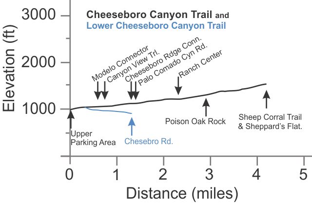
 Description This is by far the most popular trail in
the area and because of the natural beauty of Cheeseboro Canyon year round,
and the consitant, mostly gentle climb. At the upper parking area, the trail
starts as a dirt road and passes through a meadow studded with oak trees.
In the spring, the meadow and the hillsides are covered with bright yellow mustard.
About 2.9 miles from the start is "Poison Oak Rock" where the trail
crosses a small stream and narrows to a singletrack trail. From there to the
top, it is more uneven and a little steeper, and includes two short stretches
that will be challenges for even the best mountain bikers to climb.
Because of the beauty of Cheeseboro Canyon, the ease of access from parking and the number of loop routes that can be travelled, this is a popular area for hikers, mountain bikers and equestrians. As you get further from the parking, and especially beyond Sheppard's Flat, there will be fewer hikers but still lots of mountain bikes.
Up to Poison Oak Rock, the trail is pretty gentle and the tread mostly not uneven, so it's a good place for novice mountain bikers to practice.
Lower Cheeseboro Canyon Trail connects to the main Cheeseboro
Canyon Trail about a quarter mile from the upper parking lot and leads south-west
to Chesebro
Rd after a mile. It's a fire road, pretty firm but a little uneven, T1.5
![]() ,
that slopes slightly downhill towards Chesebro Rd, losing 130' of elevation
along the way. There is no parking at the Chesebro Rd end of the trail. A 0.3
miles-long singletrack trail parallels the Lower Trail, starting just south
of a short spur that leads to the base of the Calabasas Landfill. This singletrack
is closed to equestrians and mountain bikers HO
,
that slopes slightly downhill towards Chesebro Rd, losing 130' of elevation
along the way. There is no parking at the Chesebro Rd end of the trail. A 0.3
miles-long singletrack trail parallels the Lower Trail, starting just south
of a short spur that leads to the base of the Calabasas Landfill. This singletrack
is closed to equestrians and mountain bikers HO
![]() .
.
A dirt road joins the Lower Trail about 0.1 miles from Chesebro Rd and heads east. This road is short, only about 0.2 miles longs, but connects to a singletrack trail that leads further east. This is an old, rutted trail that is likely to be overgrown, but it is interesting to explore, and ends after 0.8 miles near the future 101 Freeway wildlife crossing bridge. A dirt road there leads north to the landfill, but another singletrack trails heads off to the east, making a loop that overlooks the freeway and connects to De Berry Drive in the Saratoga Hills neighborhood of Calabasas.
Technical Rating T1
![]() to Poison Oak Rock, T3
to Poison Oak Rock, T3
![]() beyond there
beyond there
|
Length (miles) |
4.2 |
|
Climb (feet) |
600 |
|
Descent (feet) |
100 |
Trail Profile Back to the Top
 [2] Modelo Trail T2.5
![]()
[3] Modelo
Connector
T2.5
![]()
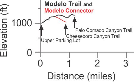
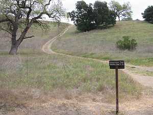
Description The Modelo Trail provides a convenient way to get from Palo Comado Canyon to the start of Cheeseboro Canyon Trail. It is a broad singletrack (sometimes a doubletrack) that connects Palo Comado Canyon Trail at one of the hight points of Palo Comado Ridge to the upper Cheeseboro parking area. As a ridgeline trail, it has its ups and downs, and no shade. For mountain bikers, it's a really fun downhill back to the parking lot!
The Modelo Connector is a steepish trail that climbs from Cheeseboro Canyon to the Modelo Trail proper. It used to be a road, but it has narrowed to a wide singletrack or doubletrack trail, much narrower than the Cheeseboro Canyon Trail where they connect.
Technical Rating T2.5
![]()
|
Length (miles) |
1.2; 0.4 for the connector |
|
Climb (feet) |
400 (south to north); 170 for the connector |
|
Descent (feet) |
100; zero for the connector |
Trail Profile Back to the Top
 [4] Canyon View Trail T1.5
![]()
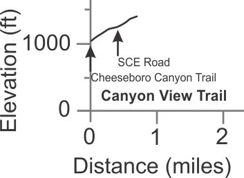
Description The Canyon View Trail climbs 0.4 miles, moderately steeply, from Cheeseboro Canyon to the SCE Road. It then makes a near 90-degree right turn, steepens a bit, and continues 0.3 miles to the top of the north face of the Calabasas landfill. Most people only go as far as the SCE Road and from there to Cheeseboro Ridge or down to Las Virgenes Canyon by one of several routes.
Technical Rating T1.5
![]()
|
Length (miles) |
0.4 to SCE Road; 0.7 to the top |
|
Climb (feet) |
200; 360 |
|
Descent (feet) |
zero |
Trail Profile Back to the Top
[5] Cheeseboro Ridge Edison
Road T1
![]()
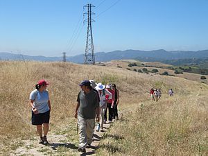 Description This
Edison Road starts at the SCE Road and heads north. It is 100% fire
road and has a few challenging climbs. It has some good views into Cheeseboro
Canyon but is not nearly as pretty as the canyon because there are few trees
and the road follows a major power line. It is generally well-maintained but
it can get to be very dusty in the summer.
Most people will follow the Edison road between SCE Road and Sheep Corral Trail as part of a loop route, but the Edison Road continues north to Albertson Motorway where it ends. Along the way, there are three connections to Albertson Motorway (Hidden Treasure, Norway and The Chute) and the Bell Canyon Trail leads to Bell Canyon Fire Road. All of these are entertaining, somewhat technical singletrack trails for experienced mountain bikers to enjoy. These other trails are a long way from any trailhead, but any hikers who make it here will likely be alone in the wilderness. There can be spectacular displays of wildflowers here in the spring.
Technical Rating T1
![]()
|
Length (miles) |
4.2 to Sheep Corral Trail; 6.4 to Bell Canyon Trail |
|
Climb (feet) |
Sorry, the elevation profile is too ragged to estimate cumulative climbs and descents. |
|
Descent (feet) |
Trail Profile Back to the Top

[6] Cheeseboro
Ridge Connector T1.5
![]()
[7] Las
Virgenes Connector T1.5
![]()
Description These two trails are probably the shortest and quickest way to get from Cheesboro Canyon to Las Virgenes Canyon. It's a gentle climb from Cheeseboro Canyon Trail up to Cheeseboro Ridge, but much steeper down from there into Las Virgenes. Both trails are dirt roads; the Las Virgenes Connector is usually more uneven and rutted, probably because it's a lot steeper.
Technical Rating T1.5
![]()
|
Length (miles) |
Ches Ridge Connector: 0.7; Las Virgenes Connector: |
|
Climb (feet) |
CRC: 165; LVC: 350 (from LV Canyon to Ches Ridge) |
|
Descent (feet) |
Both Zero |
Trail Profile Back to the Top

[8] Morrison Ranch
Road T1
![]() ,
T2
,
T2
![]()
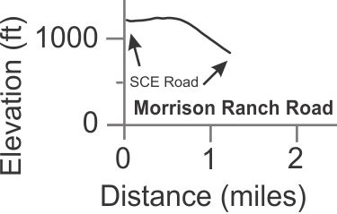
Description Most of this old ranch road is still used for vehicles
to access the area. The lower section between the ZY
Connector and the SCE Road singletrack has narrowed to a singletrack,
rated at T2
![]() because of it's width, and it's a little uneven.
because of it's width, and it's a little uneven.
Technical Rating T1
![]()
|
Length (miles) |
1.2 |
|
Climb (feet) |
60 (west to east) |
|
Descent (feet) |
440 |
Trail Profile Back to the Top
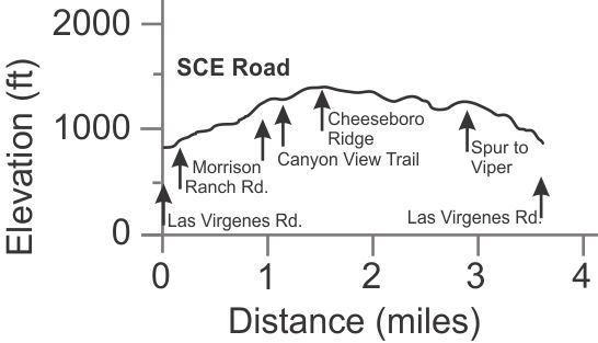
 Description This Edison road used to be fairly well
used by service vehicles, but at some point the southern leg was abandoned for
the Morrison Ranch Road. As such, the
southern leg has become a singletrack trail.
The Edison road part is broad and fairly even T1
![]() ,
but some of it can become very dusty in the summer, especially the western leg
between Canyon View Trail and Cheeseboro
Ridge Edison Road. The north leg is hilly with a number of descents, so
there may be more climbing than you might expect to get from Las
Virgenes Canyon to Cheeseboro Ridge. And the bottom is pretty steep!
,
but some of it can become very dusty in the summer, especially the western leg
between Canyon View Trail and Cheeseboro
Ridge Edison Road. The north leg is hilly with a number of descents, so
there may be more climbing than you might expect to get from Las
Virgenes Canyon to Cheeseboro Ridge. And the bottom is pretty steep!
The southern singletrack section T2
![]() is
also pretty steep and a grunt for mountain bikers to climb, but it's really
fun to mostly glide down it!
is
also pretty steep and a grunt for mountain bikers to climb, but it's really
fun to mostly glide down it!
|
Length (miles) |
2.1 (LV Rd to Cheeseboro Ridge); 1.1 (LV Rd to Canyon View) |
|
Climb (feet) |
720 (LV Rd to Cheeseboro Ridge); 470 (LV Rd to Canyon View) |
|
Descent (feet) |
200 (LV Rd to Cheeseboro Ridge); 20 (LV Rd to Canyon View) |
Trail Profile Back to the Top
 [10] Ranch Center Road T1
![]()
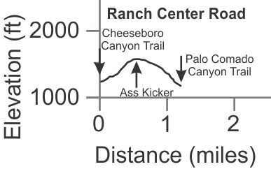
Description Ranch Center is a miserable, steep, summertime hot fire road that connects Cheeseboro Canyon and Palo Comado Canyon. Even so, it is the route to give access to the Ass Kicker and Dublin DH Trail that advanced mountain bikers might like to try.
Technical Rating T1
![]()
|
Length (miles) |
1.2 |
|
Climb (feet) |
360 (from Cheeseboro Cyn to Palo Comado Cyn) |
|
Descent (feet) |
430 |
Trail Profile Back to the Top
[11] Palo Comado Canyon Trail T2
![]()
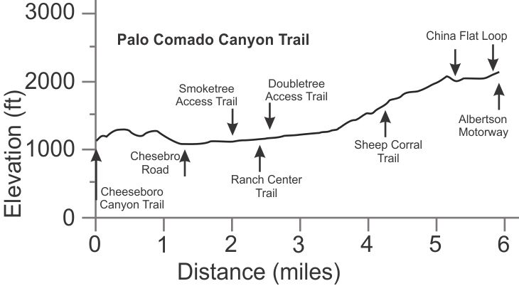
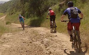 Description This fire road starts in Cheeseboro Canyon
1.4 miles from the parking lot, crosses over the Palo Comado Ridge to Palo Comado Canyon,
then climbs all the way to Albertson Motorway after passing through China Flat. It has
some rocky, possibly rutted sections above Sheep Corral
Trail and some sandy sections below it. Even so, it isn't technically challenging for
mountain bikers but it has some long, hard climbs and so is best left to experience bikers. And there are some tough climbs to get back to Cheeseboro Canyon
if that's where you started. This is a killer hot trail in the summer with no shade.
 The
upper photo is of the upper section; the one to the right is from the lower
section. There aren't any trees on the section avove Sheep Corral Trail
until you get to China Flat.
When getting back into Cheeseboro Canyon, it is more fun/interesting to turn onto the Modelo Trail single track to get back to the parking lot than to descend the fairly steep fire road to the Cheeseboro Canyon trail.
Technical Rating T2
![]()
|
Length (miles) |
5.9 |
|
Climb (feet) |
1500 |
|
Descent (feet) |
500 |
Trail Profile Back to the Top
 [12] Sheep Corral
Trail T2.5
![]() ,
T3
,
T3
![]() ,
T4.5
,
T4.5 ![]()
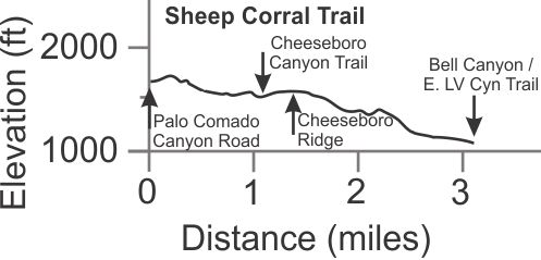
Description Sheep Corral trail is an east-west singletrack
link that connects the major north-south trails of Las
Virgenes Canyon, Cheeseboro Ridge, Cheeseboro
Canyon and Palo Comado Canyon. The character of
the trail varies greatly on the different sections. Between Las Virgenes
Canyon and Cheeseboro ridge, the trail is quite technical with several steep,
rocky sections (see photo). There is only a little exposure, but it is nasty
T4.5 ![]() .
For mountain bikers, it should be ridden by very experienced riders only. Between
Cheeseboro Ridge and the Cheeseboro Canyon Trail, the Sheep Corral Trail has
some significant ruts but there is no exposure and no steep sections T2.5
.
For mountain bikers, it should be ridden by very experienced riders only. Between
Cheeseboro Ridge and the Cheeseboro Canyon Trail, the Sheep Corral Trail has
some significant ruts but there is no exposure and no steep sections T2.5
![]() .
.
Probably the most used section is between Cheeseboro Canyon and
Palo Comado by people heading for China Flat, or only to the overlook
just before Palo Comado Canyon. The trail here also has substantial ruts and
there is some substantial climbing T3
![]() .
About 100 feet west of Sheppard's Flat, the trail branches for about an eighth
of a mile. The southern branch is a little more difficult.
.
About 100 feet west of Sheppard's Flat, the trail branches for about an eighth
of a mile. The southern branch is a little more difficult.
Technical Rating T2.5
![]() ,
T3
,
T3
![]() ,
T4.5
,
T4.5 ![]()
|
Length (miles) |
1.1 from Cheeseboro Canyon to Palo Comado Canyon; 2.0 from Cheeseboro Cyn to Las Virgenes Canyon |
|
Climb (feet) |
350; 150 |
|
Descent (feet) |
150; 580 |
Trail Profile Back to the Top
[13] East
Las Virgenes Canyon Trail T1
![]()
[14] Bell Canyon
Fire Road T2.5
![]()
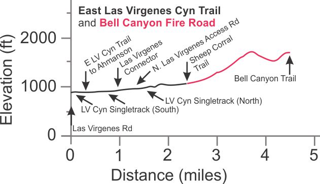
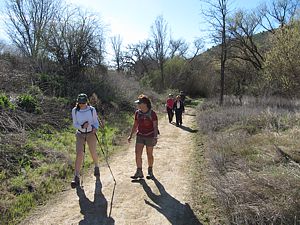 Description The
East Las Virgenes Canyon Trail T1
![]() is a gently rolling fire road that comes from the east in Ahmanson
Ranch, then turns north up Las Virgenes Canyon proper. It ends at Sheep
Corral Trail, becoming Bell Canyon Fire Road. Even though it comes from
Ahmanson, we think of the spur that joins it from the north end of Las Virgenes
Road as part of this trail, since that's the main way that people access it.
is a gently rolling fire road that comes from the east in Ahmanson
Ranch, then turns north up Las Virgenes Canyon proper. It ends at Sheep
Corral Trail, becoming Bell Canyon Fire Road. Even though it comes from
Ahmanson, we think of the spur that joins it from the north end of Las Virgenes
Road as part of this trail, since that's the main way that people access it.
The trail isn't as popular as Cheeseboro Canyon because Cheeseboro is exceptionaly pretty, but this is a good place to get away from the crowds. It is a pretty canyon with some oak trees with high ridges to the east and west.
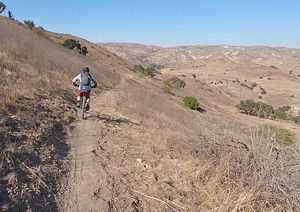
The tread is typical for this kind of road in the area - fairly even and no big ruts, but there are a couple of low spots that collect water and turn into giant mud puddles in the wet season. One has a trail around it; the other(s) you just need to skirt the edge and stay as dry as you can.
 The
Bell Canyon Fire Road T2.5
![]() becomes steeper and more rocky as you travel north. This correspondent hasn't
explored it north of the Bell Canyon Trail.
becomes steeper and more rocky as you travel north. This correspondent hasn't
explored it north of the Bell Canyon Trail.
|
Length (miles) |
2.4 to Sheep Corral; 4.5 to Bell Canyon Trail |
|
Climb (feet) |
280 to Sheep Corral; 1100 to Bell Canyon Trail |
|
Descent (feet) |
70 to Sheep Corral; 270 to Bell Canyon Trail |
Trail Profile Back to the Top
 [15] Zipper Trail T2.5
![]()
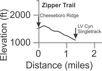
Description This is an unofficial singletrack trail that runs from Cheeseboro Ridge at the west end down to Little Sketchy and then Las Virgenes Canyon. For hikers, it's much prettier than SCE Road that it more-or-less parallels and so is a more pleasant way to connect Las Virgenes Canyon and Cheeseboro Ridge, in either direction. For mountain bikers, it's super fun downhill, but it's not for beginners. Going the other way, it's pretty steep so other routes are better for climbing up to Cheeseboro Ridge from Las Virgenes Canyon.
The photo shows a transverse section with Las Virgenes Canyon below to the right.
Technical Rating T2.5
![]()
|
Length (miles) |
1.3 |
|
Climb (feet) |
110 (From Cheeseboro Ridge to LV Canyon Singletrack) |
|
Descent (feet) |
520 |
Trail Profile Back to the Top
[16] Las
Virgenes Canyon Singletracks,
North (aka "Ho Chi Minh")
and South
(aka "Little Sketchy") T1.5
![]()
|
|
|
Description These are two separate trails. What they have in common is that they both run parallel to the E. Las Virgenes Canyon Trail a little way up hillside to the the west, provide some good views of both the canyon and the ridge to the east, and are less traveled than the canyon trail. Also, both can become severely overgrown in the spring.
The 1.0 mile long South trail climbs steeply
from the north end of Las Virgenes Road for about 500 yards. The trail here
is very narrow with a steep drop-off T4.5 ![]() .
(When a group of very experienced mountain bikers rode down this section for
the first time, a number of them commented at the bottom that the trail was
a little sketchy, hence the nickname.)
.
(When a group of very experienced mountain bikers rode down this section for
the first time, a number of them commented at the bottom that the trail was
a little sketchy, hence the nickname.)
The rest of the trail is much less techical - not so steep and
without bad exposure T2.5
![]() .
The north end drops back down through some very loose rock and can be very
sketchy, but that difficult section is not nearly as long as at the south end.
.
The north end drops back down through some very loose rock and can be very
sketchy, but that difficult section is not nearly as long as at the south end.
About 400 yards beyond the north end of the South section, on
the Las Virgenes Connector, the 0.7 mile long North trail T2.5
![]() starts. There are two ways to access it - about 100 yards from E
LV Canyon Trail, and the Alternate trail about 450 yards further up
the Las Virgenes Connector. Both
routes have a very steep approach. Mountain bikers coming down from Cheeseboro
Ridge can get a little speed to give them some momentum to start up the
steep Alternate hill, but heavy duty pedalling will still be needed. The climb
on the route closer to the bottom is very short, but super steep and loose -
impossible for most to pedal up. (This won't be a problem for hikers.) The trail
itself is much more gentle and doesn't have any really technical sections like
the South trail. In general, it's a much more fun and interesting route than
the E LV Canyon trail for everyone, so long as it's not completely overgrown.
starts. There are two ways to access it - about 100 yards from E
LV Canyon Trail, and the Alternate trail about 450 yards further up
the Las Virgenes Connector. Both
routes have a very steep approach. Mountain bikers coming down from Cheeseboro
Ridge can get a little speed to give them some momentum to start up the
steep Alternate hill, but heavy duty pedalling will still be needed. The climb
on the route closer to the bottom is very short, but super steep and loose -
impossible for most to pedal up. (This won't be a problem for hikers.) The trail
itself is much more gentle and doesn't have any really technical sections like
the South trail. In general, it's a much more fun and interesting route than
the E LV Canyon trail for everyone, so long as it's not completely overgrown.
Technical Rating T2.5
![]() ,
T4.5
,
T4.5 ![]() on
Little Sketchy
on
Little Sketchy
Trail Profile Back to the Top

[17] Smoke Tree Connector T1
![]()
Description This is a hilly double-track trail to access Palo Comado Canyon from Smoke Tree Ave. in Oak Park. It's too short to show an elevation profile. This is a convenient way to get to Palo Comado Canyon from Oak Park.
Technical Rating T1
![]()
|
Length (miles) |
0.5 |
|
Climb (feet) |
140 (from Doubletree Road to Palo Comado Canyon) |
|
Descent (feet) |
75 |
[18] Doubletree
Access Trail T1.5
![]()
Description This trail provides access to Palo Comado Canyon from Oak Park, starting at Doubletree Road, and is less hilly than Smoke Tree Connector. It's a narrow dirt road with some minor ruts and a little loose gravel in places. To get to China Flat, this is the easiest place to start. It's too short to show an elevation profile.
Technical Rating T1.5
![]()
|
Length (miles) |
0.45 |
|
Climb (feet) |
85 (from Smoke Tree Ave to Palo Comado Canyon) |
|
Descent (feet) |
90 |
 [19] Bell
Canyon Trail (aka Tecate)
T4.5
 ![]()
Description This remote trail sees little traffic and no maintenance, so it's frequently overgrown and has many ruts, some of them extremely deep. For mountain bikers, this is a difficult ride that anyone other than a very experienced rider will hate. It has a lot of climbing and seemingly miles of tough, loose, rocky technical sections. Also, it's a long way from any trailhead if an injury or exhaustion should occur. Nevertheless, for advanced riders who have lots of endurance and love rocky trails, this trail is great! It has all the nasties: some sections are seriously rutted, there are loose rocks, parts go through a rocky stream bed, there are steep sandy climbs and overgrown parts. After what seems like much more that it's 1.4 mile length, the single track joins the poorly maintained Bell Canyon Fire Road that itself has some loose sections, sandy climbs and big ruts. In other words, you're not out of the woods yet! There are a number of intersecting roads and forks here so this is best ridden with someone who knows the way, or can download the GPS track and can follow them.
The best time to ride this trail is shortly after a wildfire comes through and opens up the trail by burning back the overgrowth. It will also expose the ruts so they're easier to avoid.
To get a good idea of what the trail is like, watch this video, starting at 8:28.
Technical Rating T4.5 ![]()
|
Length (miles) |
1.4 |
|
Climb (feet) |
300 (from Cheeseboro Ridge Edison Rd to Bell Canyon Fire Rd) |
|
Descent (feet) |
340 |
Trail Profile Back to the Top

[20] Ass Kicker
T2
![]() and
Dublin DH Trails T4
and
Dublin DH Trails T4
![]()
 Description These
are really just one unofficial trail that leads from the top of Ranch
Center Rd to lower Palo Comado, probably established
by downhiller mountain bikers. Ass Kicker is a very steep uphill doubletrack
that leads to the peak of Palo Comado Ridge where Dublin DH starts. The trail
is fairly firm but is very very steep. If you're on a bike, expect to push
it up. If you're hiking, you can look forward to some great views in every direction
at the top. The photo shows the view from the top, looking south and down Dublin
DH.
Dublin DH appears to be a downhill mountain biking trail. It has long sections that are steep and loose. It's very bumpy from gopher holes and possibly hooves. There are some small jumps, mostly avoidable except for some near the top that are easy to roll over. From a technical perspective, you shouldn't attempt this trail unless you are a very experienced mountain biker. Even then you may not like it because it's so bumpy.
|
Length (miles) |
0.3 (Ass Kicker) 1.1 (Dublin DH) |
|
Climb (feet) |
240 (from Ranch Center to Dublin DH, on Ass Kicker) |
|
Descent (feet) |
730 (from Ass Kicker to Palo Comado, on Dublin DH) |
Trail Profile Back to the Top

[21] Zev
Yaroslavsky Trail T1.5
![]()
[22]
Zev Yaroslavsky Connector T1
![]()
[23] Zev Yaroslavsky
Overlook Trail T2
![]()
 Description The
Zev
Yaroslavsky (ZY for short) Trail is a paradise for hikers and trail runners
looking for a serious conditioning workout in the ZY
Las Virgenes Highlands Park. The park is directly south of the western section of
the Upper
Las Virgenes Canyon Open Space area with a convenient parking area
on Las Virgenes Rd. The landscape is mostly grasslands on a steep hillside
with a number of oak trees scattered around. From the overlook, there is a
great view in all directions, especially to the southeast over the 101 freeway.
There are also spots where you have a good view into the goings-on of the
Calabasas Landfill.
The ZY Trail is very steep, too steep for bikes to ride up very far, but it's popular for hikers and people walking their dogs. The trail itself is a narrow dirt road that looks like it's been lightly scraped by a grader. Overall it's pretty solid with a few small loose rocks on the surface. The ZY Connector is similar, except it's a transverse trail so not steep at all.
The ZY Overlook Trail is a singletrack that goes to an overlook with the best views southerly. There's a great view of the 101freeway, and also a good view of the landfill that's just to the west. The trail isn't steep and is mostly pretty firm. The photo is looking north along the ZY Overlook Trail with the ZY Connector visible in the distance.
Technical Rating T1
![]() ,
T1.5
,
T1.5
![]() ,
T2
,
T2
![]()
|
Length (miles) |
ZY Trail: 1.1 ZY Overlook: 0.1 ZY Connector: 0.3 |
|
Climb (feet) |
ZY Trail: 635 ZY Overlook: 30 ZY Connector: 30, heading northwest to Morrison Ranch Rd. |
|
Descent (feet) |
ZY Trail: 180 ZY Overlook: zero ZY Connector: 10, heading northwest |
Trail Profile Back to the Top

This page was last updated January 27, 2021.
|
|
Thanks for looking at Steve's guide to trails in Ventura County, the Santa Monica Mountains National Recreation Area (SMMNRA) and other locations. |
|