Trails of
China Flat, with
connecting trails
Overview
of adjacent areas
Hiking
along the China Flat Loop East
China flat is a very pretty area with groves of oak trees, grassy meadows and hillsides of chaparral. As you might assume from its name, there are no long hills. There are a number of trails that are very attractive for hiking, as well as really fun for mountain bikers.
In addition, it serves as a connection for four major areas - to Cheeseboro Canyon via Palo Comado Canyon Rd, to Lang Ranch by way of Albertson Motorway, to Oakbrook Regional Park through the Secret Passage to Simi Peak, and to Oak Park along the China Flat Trail and Suicide Trail. As such, there are also multiple approaches to access this area, and is key to a number of loop routes. For mountain bikers, the easiest access is from Cheeseboro Canyon and Palo Comado Canyon Rd or from Lang Ranch and Albertson Mtwy. For hikers, the shortest route is from Oak Park.
|
|
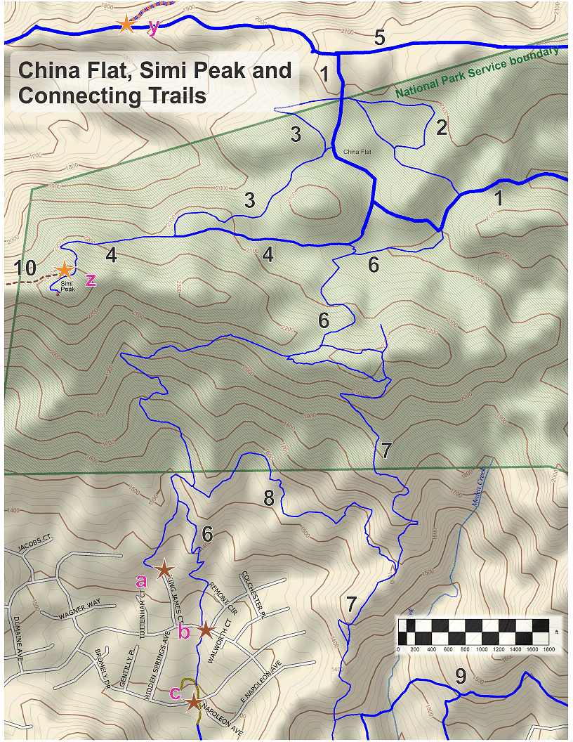
Trailheads, Parking and Features
a. At the north end of King James Court. There is street parking here. Map
and directions
b. Lindero Canyon Road. There is parking on nearby
streets. Map
and directions
c. Bromely Drive. There is street parking here. Map
and directions
y.
Locked gate
z. Simi Peak
Download the GPS tracks ![]() to help you find your way. This GPX file contains tracks for all the trails
in this area.
to help you find your way. This GPX file contains tracks for all the trails
in this area.
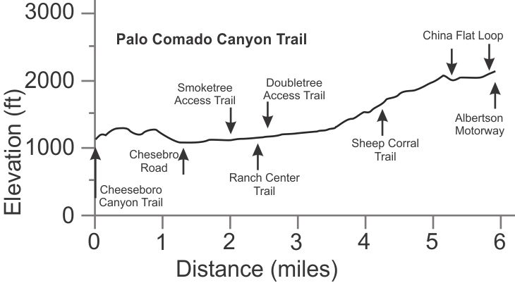
[1] Palo Comado Canyon Trail T1.5
![]()
Description The Palo Comado Canyon Trail is a fire road that starts in Cheeseboro Canyon, crosses over the ridge to Palo Comado Canyon, then climbs all the way to Albertson Motorway. There are two short connector trails to Oak Park. Palo Comado is the most common way to access China Flat. For more info on this trail, view its description on the Cheeseboro, Palo Comado and Las Virgenes Canyons page.
Technical Rating T1.5
![]()
|
Length (miles) |
5.9 |
|
Climb (feet) |
1500 |
|
Descent (feet) |
500 |
Trail Profile Back to the Top
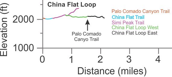
[2,
3] China Flat Loop East, China Flat Loop West T2
![]()
 Description The China Flat Loop consists of several
trails. Starting at Palo Comado Canyon Trail (coming up from Cheeseboro Canyon)
and travelling clockwise, the order of the trails is this: Palo Comado Canyon
Trail, China Flat Trail, Simi Peak Trail, China Flat Loop West and finally,
China Flat Loop East. This is a pretty route with sections consisting of grasslands,
chaparral and mature oak trees. Mountain bikers find this is a really fun trail
with generally gentle climbs and descents. It's easier to ride in the clockwise
direction because the climbs are less steep that way.
Description The China Flat Loop consists of several
trails. Starting at Palo Comado Canyon Trail (coming up from Cheeseboro Canyon)
and travelling clockwise, the order of the trails is this: Palo Comado Canyon
Trail, China Flat Trail, Simi Peak Trail, China Flat Loop West and finally,
China Flat Loop East. This is a pretty route with sections consisting of grasslands,
chaparral and mature oak trees. Mountain bikers find this is a really fun trail
with generally gentle climbs and descents. It's easier to ride in the clockwise
direction because the climbs are less steep that way.
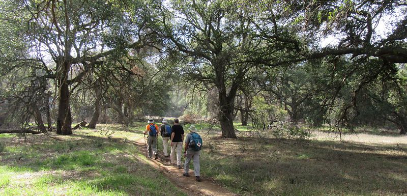
The photo at the top of the page shows an oak grove on the East loop and the photo to the right shows one of the many meadow areas, this one being along the west Loop.
Technical Rating T2
![]()
|
Length (miles) |
2.1 |
|
Climb (feet) |
300 |
|
Descent (feet) |
300 |
Trail Profile Back to
the Top
(Travelling clockwise, starting at Palo Comado coming up from
the bottom.)
[4] Simi Peak Trail T3
![]()

Description There's a great view in all directions from Simi Peak at the top of the trail. The photo at right is looking south-east, overlooking the China Flat Trail with Suicide in the distance. The trail starts off as the bottom leg of the China Flat Loop, then continues west and then south, up to Simi Peak. It doesn't get all that much use and is never maintanied so you can expect it to be a bit overgrown with uneven and rutted tread. Even so, the view is worth the trek.
Technical Rating T3
![]()
|
Length (miles) |
0.85 |
|
Climb (feet) |
350 total; 235 from the China Flat Loop |
|
Descent (feet) |
40 |
Trail Profile Back to
the Top
The elevation profile is above, part of the China Flat Loop profile.
[5] Albertson Motorway T1
![]()
Description Albertson Motorway climbs steadily and mostly moderatly from Lang Ranch Parkway to China Flat and continues east. For a full description, see it on the Lang Ranch page.
Technical Rating T1
![]()
Trail Profile Back to the Top

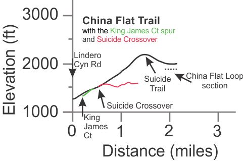
[6] China Flat Trail (AKA Dead Cow
Road) T4
![]()
 Description Most
of the China Flat Trail is an old fire road that has not been maintained.
It's probably the simplest way to hike up to China Flat, starting at the
Lindero Canyon Road trailhead. The last 400 yards is part of the China
Flat Loop.
Description Most
of the China Flat Trail is an old fire road that has not been maintained.
It's probably the simplest way to hike up to China Flat, starting at the
Lindero Canyon Road trailhead. The last 400 yards is part of the China
Flat Loop.
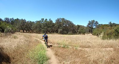
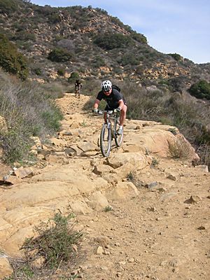
For mountain bikers, it is quite a technical, bumpy ride down over the rocks and through the ruts, but really fun if you're up to it! Intermediate riders should be able to make their way down slowly but they will probably want to walk some stretches of it (see photo at right). Novices will want to avoid this trail.
There are two trails that head east from the apex of the China Flat Trail. The one closest to China Flat is Suicide. The one closer to Oak Park is a rocky ridgeline trail that joins to Suicide. Both are rocky and difficult. It you want to get to the top of Suicide, you'll have to pick your poison. About a mile from the apex (towards Oak Park) is another trail that comes in from the east, the Suicide Crossover trail which is even more rocky than the China Flat Trail.
Technical Rating T4
![]()
|
Length (miles) |
2.15 |
|
Climb (feet) |
900 |
|
Descent (feet) |
200 |
Trail Profile Back to the Top
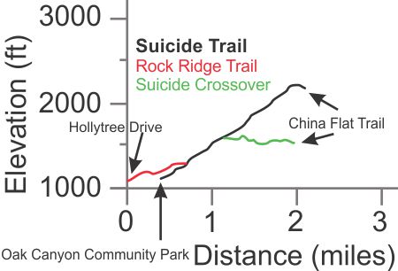
[7] Suicide Trail T5
![]()
 Description You
can get an idea of what this trail is about from its name. Suicide is moderately
steep and often very rocky. It is a favorite of downhill mountain bikers who
like to ride down it fast. They have built a number of jumps and other
features at the sides of the trail. You need to be an expert rider to enjoy
going down this trail! Even though it's only a little steeper, it's much more
difficult than the China Flat Trail.
Description You
can get an idea of what this trail is about from its name. Suicide is moderately
steep and often very rocky. It is a favorite of downhill mountain bikers who
like to ride down it fast. They have built a number of jumps and other
features at the sides of the trail. You need to be an expert rider to enjoy
going down this trail! Even though it's only a little steeper, it's much more
difficult than the China Flat Trail.
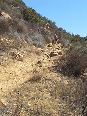
For hikers, it's another way to get to China Flat from Oak Park. The trail and the scenery are both very rocky and interesting to look at.
For everyone, this trail is on a south-facing slope and so gets brutally hot in the summer.
The profile below shows the section of the Rock Ridge Trail that connects to Suicide and ends at Hollytree Drive because this is a popular route to access and exit the trail. The bottom of this trail drops of the map on this page, but you can see it all on the Oak Park page.
Technical Rating T5
![]()
|
Length (miles) |
1.75 from Oak Canyon Community Park 2.1 from Hollytree Drive |
|
Climb (feet) |
1100 from Oak Canyon Community Park 1100 from Hollytree Drive |
|
Descent (feet) |
100 from Oak Canyon Community Park 100 from Hollytree Drive |
Trail Profile Back to the Top
[8] Suicide Crossover T4.5 ![]()
Description This trail connects the China Flat Trail, about a half mile from Lindero Cyn Rd, to Suicide. It's mostly not steep, but it has some very rocky sections, and a places with a lot of exposure where the trail is very narrow. For hikers, it's pretty easy, but for mountain bikers, you need to be really good to ride it all. Your correspondent considers himself a decent rider, but he walked his bike at a number of spots.
Technical Rating T4
![]()
|
Length (miles) |
0.8 |
|
Climb (feet) |
|
|
Descent (feet) |
Trail Profile Back to the Top
The elevation profile for Suicide Crossover is shown on both the China Flat and Suicide Trails profiles.
[9] Rock Ridge Trail (East) T2
![]()
Description This single-lane-wide dirt road is described on the Oak Park trails page.
Technical Rating T2
![]()
|
Length (miles) |
1.25 |
|
Climb (feet) |
450 (from Hollytree to Deerhill) |
|
Descent (feet) |
175 |
Trail Profile Back to the Top

[10] Secret
Passage to Simi Peak
Description This is an amazingly beautiful trail for hiking, but it's way too steep and rocky for mountain biking. See the full description on the Lang Ranch Map.
This page was last updated December 24, 2020.
|
|
Thanks for looking at Steve's guide to trails in Ventura County, the Santa Monica Mountains National Recreation Area (SMMNRA) and other locations. |
|