Trails of
North Ranch
Overview
of adjacent areas
Hillcrest
Ridge Trail, with the Cutoff visible at the top of the hill
This area is dominated by two trail systems: the Hillcrest Ridge - White Sage Trail loop, and Saddle Pass Trail and its connections. Both systems run up to the top of prominent ridges with several connections to nearby neighborhoods. The ridgetops provide great views in every direction and the sometimes steep ridgeline trails provide great exercise. At the time of this writing (January 2022), the Wishbone Trail is the newest major trail in the Conejo Valley, completed in 2019. A hidden beauty is tucked away in the north-east corner of this area, the Lindero Creek Trail.
Because of the steepness of the trails, none of them are favored by mountain bikers. But they're great for people who want to get in a quick work-out hike.
There is easy connectivity to the Oakbrook trails to the north and Oak Park trails to the east. The overview of adjacent areas shows how these areas are connected.
|
|
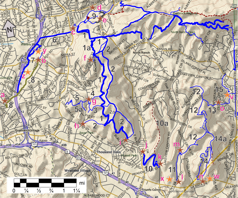
Trailheads, Parking and Features
a. South-east end of Gainsborough Rd. Map
and directions.
b. Janss Rd at Paige
Ln. There is parking on Paige Ln. Map
and directions.
c. Scenicpark St. entrance to Sapwi
Trails Community Park. Map
and directions.
d. Adenida De Los Arboles entrance to Sapwi
Trails Community Park. Map
and directions.
e. Westlake Blvd entrance to Sapwi Trails Community
Park. Map
and directions.
f. North end of Grissom St. Map
and directions.
g. South end of La Granada
Dr. and Crown View Court. Map
and directions.
h. Conejo Bluff Ct, but there is no parking.
You can park on Conejo School Rd. Map
and directions.
i. East Hillcrest Dr. There is no
parking here. Map
and directions.
j. Westlakd Blvd. There is no parking here. Map
and directions.
k.
Lakeview Canyon Rd. Parking is severely restricted here so check the signs.
Map
and directions.
l.
Driveway to Westlake High School. No parking on Via Merida. Map
and directions.
m. Country
Valley Rd. There is no vehicle access here. Map
and directions.
n. Westlake Village Community
Park and YMCA on Thousand Oaks Blvd. Map
and directions.
o. Bowfield St. just west of
Rockfield St. Map
and directions.
z. Conejo Creek Park South and parking. Map
and directions.
y. Conejo Creek
Park North and parking. Map
and directions.
x. Westlake High School.
w. Westlake
Village Community Park and YMCA. Map
and directions.
v. North Ranch Playfield and parking
on Bowfield St. Map
and directions.
Download the GPS tracks ![]() to help you find your way. These GPX files contains tracks for all the trails
in this area:
to help you find your way. These GPX files contains tracks for all the trails
in this area:
 [1] White
Sage Trail T1
[1] White
Sage Trail T1
![]()
[1a]
White Sage Edison Road T1
![]()
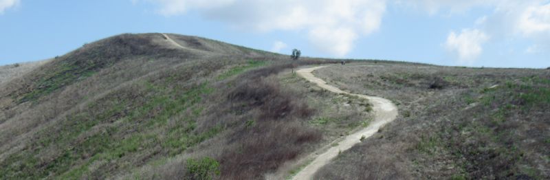
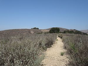
Description The White Sage Trail is an Edison Road that runs from Sapwi Trail in the north to the Hillcrest Ridge Trail in the south. It's in good shape and not very steep, with some good views to the west. With the Hillcrest Ridge Trail (upper trail in the photo at right), it can make a nice loop route, although Hillcrest Ridge is really steep in spots and is quite a bit more strenuous.
Connections to the street are via the Sapwi Trail in the north, Hillcrest Ridge in the south, and Arabian Run and Dapple Gray/La Granada towards the south end.
1a White Sage Edison Road: T1
![]() This is a short and quite steep shortcut
that you can use to cut a few hundred feet off your travels if you want to get
from the main section of White Sage to Sapwi Trail.
This is a short and quite steep shortcut
that you can use to cut a few hundred feet off your travels if you want to get
from the main section of White Sage to Sapwi Trail.
Technical Rating T1
![]()
|
Length (miles) |
3.3 for White Sage Trail; 0.5 for White Sage Edison Rd |
|
Climb (feet) |
1050 (north to south); 510 |
|
Descent (feet) |
700; 45 |
Trail Profile Back to the Top
This is a fairly complicated elevation profile as it shows four trails and where they meet. If the lines intersect, the trails meet at that point, except for the very right end of the White Sage Trail line. Where it crosses the green Hillcrest Ridge Trail line, the trails don't meet there. Instead, they meet where the arrows point for "Junction White Sage & Hillcrest Ridge." On the ground, the Hillcrest Ridge Trail loops around and comes back to the White Sage Trail, but that can't be represented in the chart. Also, the left (north) end of the White Sage Edison Rd runs into the White Sage Trail, and that is shown on the profile by the "Junction White Sage & WS Edison Rd" label.

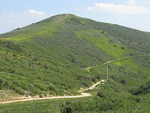
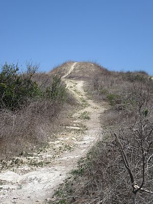
 [2] Hillcrest
Ridge Trail T1
[2] Hillcrest
Ridge Trail T1
![]() ,
T2
,
T2
![]() ,
T4.5
,
T4.5 ![]()
[2a]
Hillcrest Ridge Cutoff
Description The Hillcrest Ridge Trail is mostly a broad
trail that runs from south White Sage Trail in the north, touches Hillcrest
Blvd, widens to a dirt road and turns north to loop around to the south
end of White Sage Trail, then becomes a singletrack T2
![]() that heads west to end at Conejo Bluff Court. As a ridgeline trail, it
is very steep in places, and then extremely steep T4.5
that heads west to end at Conejo Bluff Court. As a ridgeline trail, it
is very steep in places, and then extremely steep T4.5 ![]() as
it drops from the south end of the ridge to Hillcrest Blvd. This makes it great
for a conditioning hike or run (see photo at right), but it's too steep for most mountain bikes to climb.
There are great views from the ridge in several places, but very little in the
way of shade, so choose your hiking time carefully. In the spring this ridge
can be covered with mustard and so can be very colorful! The singletrack section
from the south end of White Sage to Conejo Bluff Court is fairly smooth but
a bit steep in places, and is liable to be overgrown with mustard in the spring
T2
as
it drops from the south end of the ridge to Hillcrest Blvd. This makes it great
for a conditioning hike or run (see photo at right), but it's too steep for most mountain bikes to climb.
There are great views from the ridge in several places, but very little in the
way of shade, so choose your hiking time carefully. In the spring this ridge
can be covered with mustard and so can be very colorful! The singletrack section
from the south end of White Sage to Conejo Bluff Court is fairly smooth but
a bit steep in places, and is liable to be overgrown with mustard in the spring
T2
![]() .
.
To recap, the broad part of the trail from the north end until
Hillcrest Ridge Cuttof rates T1
![]() ;
the section from there to the top of the steep hill is T2
;
the section from there to the top of the steep hill is T2
![]() ,
and the steep hill itself that leads to Hillcrest Blvd is T4.5
,
and the steep hill itself that leads to Hillcrest Blvd is T4.5 ![]() because it's a little loose and extremely steep. From Hillcrest Blvd so the
south end of White Sage is T1
because it's a little loose and extremely steep. From Hillcrest Blvd so the
south end of White Sage is T1
![]() ,
and the singletrack from there to Conejo Bluff Court is T2
,
and the singletrack from there to Conejo Bluff Court is T2
![]() .
.
2a Hillcrest RIdge Cutoff:
T2
![]() This 1000' double-track-width trail climbs 150' between two parts of the Hillcrest
Ridge Trail, making it quite steep - too steep for most mountain bikers to climb.
Generally the tread is in good shape but there's a little loose gravel on the
top, making it a bit slippery.
This 1000' double-track-width trail climbs 150' between two parts of the Hillcrest
Ridge Trail, making it quite steep - too steep for most mountain bikers to climb.
Generally the tread is in good shape but there's a little loose gravel on the
top, making it a bit slippery.
Technical Rating T1
![]() ,
T2
,
T2
![]() ,
T4.5
,
T4.5 ![]()
|
Length (miles) |
3.8; Hillcrest Ridge Cuttoff is 0.2 |
|
Climb (feet) |
1000 (North to south); 0 |
|
Descent (feet) |
1400; 150 |
The trail profile is included with the description of the White Sage Trail above.
[3] Dapple
Gray T2.5
![]() and La Granada Trails T2
and La Granada Trails T2
![]()
Description The La Granada Trail is a singletrack
that runs roughly parallel to Conejo School Road, starting at the cul-de-sac
at the north end of Mountain Crest Circle, ending at the fire lane that continues
north of the end of Conejo School Road. The trail then continues along the paved
fire lane until its north end where it becomes La Granada Drive. The tread of
the singletrack is in good shape and it isn't very steep. T2
![]()
The Dapple Gray Trail starts at the La Granada Trail
and climbs 0.5 miles to the Hillcrest Ridge Trail. It crosses the White Sage
Trail 0.3 miles from the bottom. The tread is in pretty good shape but it is
quite steep in spots, going straight up the ridgeline as it does. It gets even
steeper after it crosses the White Sage Trail. It gets a more difficult technical
rating than La Granada Trail because of the steepness. T2.5
![]()
|
Length (miles) |
La Granada Trail 0.4; Dapple Gray Trail 0.5 |
|
Climb (feet) |
100; 385 |
|
Descent (feet) |
50; zero |
The trail profile is included with the description of the White Sage Trail above.
[4] Arabian
Run Trail T2
![]()
Description This trail climbs 150' vertically over 0.2 miles from Crown View Court to the White Sage Trail. The trailhead is a little difficult to see - it's on the south-east side with no sign to mark it, a little more than half way up the hill. The tread on this singletrack is pretty firm but there are some steepish spots.
Technical Rating T2
![]()
|
Length (miles) |
0.2 |
|
Climb (feet) |
150 |
|
Descent (feet) |
zero |
The trail profile is included with the description of the White Sage Trail above.
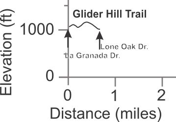
[5] Glider
Hill Trail T2.5
![]()
[5a]
Glider Hill South
Description This singletrack starts off from La Granada Dr. in pretty good shape, but soon becomes a lot rougher. It snakes around the hillside and then ends at Lone Oak Dr. Glider Hill South may be completely overgrown and impossible to locate - it was in March 2021.
Technical Rating T2.5
![]()
|
Length (miles) |
0.65 |
|
Climb (feet) |
160 from La Granada Dr. to Lone Oak Dr. |
|
Descent (feet) |
220 |
Trail Profile Back to the Top
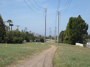 [6] Las
Flores Trail T0.5
[6] Las
Flores Trail T0.5
![]()
Description This is an Edison Road that runs underneath some power lines in an open meadowy area. The trail is very gently sloped and had a firm surface. It starts at Erbes Rd immediately south of Los Cerritos Middle School and runs west for just over a half mile where it bumps up against Avenida De Las Flores. Here it turns south and becomes the Conejo Creek Park trail that's described next. There are several connections to the neighborhood.
Technical Rating T0.5
![]()
|
Length (miles) |
0.6 |
|
Climb (feet) |
25 (starting at Erbes Rd and heading west) |
|
Descent (feet) |
55 |
Trail Profile Back to the Top
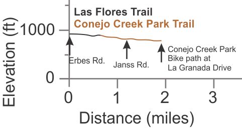
 [7] Conejo Creek
Park Trail T0.5
[7] Conejo Creek
Park Trail T0.5
![]()
Description This is a broad decomposed granite or dirt path that runs between the parking lot and the freeway. It is well separated from the freeway, but south of Janss Rd it is very noisy. The tread is pretty even and has a very gentle slope to it. It runs from Las Flores in the north, across Janss Rd and ends at the bike path next to La Granada Drive.
Technical Rating T0.5
![]()
|
Length (miles) |
1.2 |
|
Climb (feet) |
20 (heading south from Avenida De Las Flores) |
|
Descent (feet) |
120 |
The trail profile is combined with that for the Las Flores Trail directly above this description.
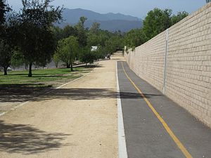
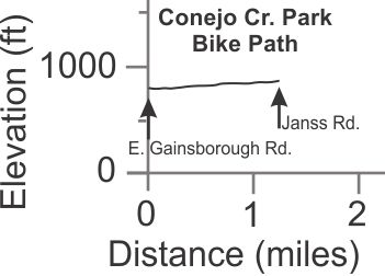
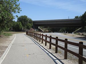 [8] Conejo
Creek Park Bike Path T0
[8] Conejo
Creek Park Bike Path T0
![]()
Description This paved bike path travels for most of its length along the east edge of the southern park of Conejo Creek Park. It is generally north-south. In the south it ends at the intersection of Gainsborough Rd. and Galsworthy St. In the north it ends at Janss Rd. The slope is very gentle making it a very easy route by bike or on foot.
Technical Rating T0
![]()
|
Length (miles) |
1.25 |
|
Climb (feet) |
100 (from the south end traveling north) |
|
Descent (feet) |
30 |
Trail Profile Back to the Top
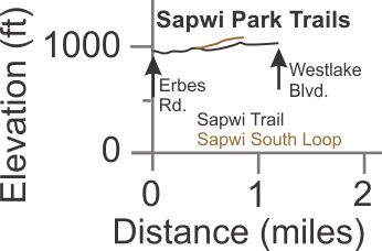
[9] Sawpi Trail
and Sapwi South Loop T2
![]()
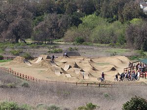 Description These trails, along with the driveways,
pretty much circumnavigate Sapwi Trails Community Park.
Description These trails, along with the driveways,
pretty much circumnavigate Sapwi Trails Community Park.
Sapwi Trails was originally planned to be a community park with ball fields and lights for playing at night. However, it was discovered that much of the area was part of an ancient landslide and was unstable. It would have cost millions of dollars to stabilize the ground to be safe for ball fields. Instead, the parks departement decided to keep it mostly natural and add facilities for underrepresented recreational activities. These include
Follow the above links to learn more about this park.
The main Sapwi Trail travels 1.2 miles from the kids' playground area on Erbes Rd at the west end to Westlake Blvd towards the north-east. There is lots of parking at the Erbes end but none at the Westlake Blvd end. The trail itself is a combination of dirt utility road and singletrack. It crosses the disc golf course a few times so watch for flying discs!
The Sapwi South Trail climbs 0.4 miles from the main trail up to the RC plane field. It ends at parking area for the RC plane pilots. The surface is in generally good condition.
Technical Rating T2
![]()
|
Length (miles) |
1.2 (main trail); 0.4 (south trail |
|
Climb (feet) |
200 (west to east); 120 |
|
Descent (feet) |
100; 40 |
Trail Profile Back to the Top
[10] Skelton
Canyon Trail T2
![]()
[10a]
Skelton Ridge Trail T3.5
![]()
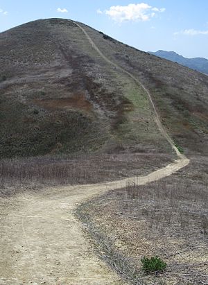
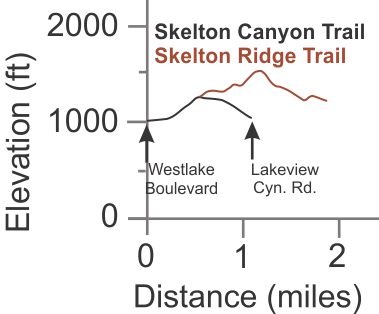
 Description The Skelton Canyon trail, just over
a mile long, starts at the west end on Westlake Blvd., climbs the ridge and
descends to Lakeview Canyon Road. There is no immediate parking at either end;
we suggest you park on Santiago St. off of Westlake Blvd. This singletrack trail
is in generally pretty good shape, can be a bit loose and a little overgrown.
It's a bit steep for mountain bikes at the start and end but can be navigated
by strong riders. The photo at the right shows it during a very dry summer.
There are a couple of trees along the way, but there's not much shade.
Description The Skelton Canyon trail, just over
a mile long, starts at the west end on Westlake Blvd., climbs the ridge and
descends to Lakeview Canyon Road. There is no immediate parking at either end;
we suggest you park on Santiago St. off of Westlake Blvd. This singletrack trail
is in generally pretty good shape, can be a bit loose and a little overgrown.
It's a bit steep for mountain bikes at the start and end but can be navigated
by strong riders. The photo at the right shows it during a very dry summer.
There are a couple of trees along the way, but there's not much shade.
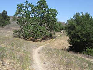
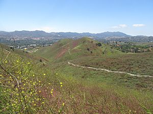
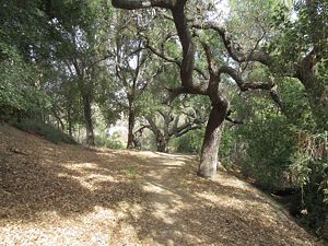
The Skelton Ridge Trail joins the Skelton Canyon
Trail at the latter's highest point. It continues almost straight up the ridge
to the top and down the other side. You can expect it to be very overgrown,
often to the point where it is completely obscured. The photo next to the elevation
profile shows
it during a strong mustard bloom. The mustard was much taller higher up the
hill! In addition, the trail is pretty steep in places. It's not suitable
at all for mountain bikes and is rated T3.5
![]() because of the overgrowth problem. But if you can find your way, it's a real
adventure!
because of the overgrowth problem. But if you can find your way, it's a real
adventure!
Technical Rating T2
![]()
|
Length (miles) |
1.1 (Skelton Canyon); 1.3 (Skelton Ridge) |
|
Climb (feet) |
250; 350 |
|
Descent (feet) |
220; 400 |
Trail Profile Back to
the Top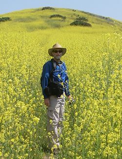
[11] Windmill Canyon
Trail T2
![]()
 Description This
is a very pretty trail that follows along the creek on the other side from Via
Merida. There is no access from this road; you get to the bottom from Westlake
High School. (Via Merida is blocked about a half mile north of Thousand Oaks
Blvd, becoming County Valley Road on the north side of the gate.) From Westlake
High, the trail runs through a meadow parallel to the stream, just above the
oak trees the grow next to the stream. Near the north end, the trail drops down
closer to the stream and goes underneath the oak canopy. The trail has a very
gentle slope and is in very good shape - it has a firm tread with no ruts. It's
a great trail for a very pleasant stroll! At the north end, the Saddle
Pass Trail continues up the steep slope on the other side of County Valley
Road.
Description This
is a very pretty trail that follows along the creek on the other side from Via
Merida. There is no access from this road; you get to the bottom from Westlake
High School. (Via Merida is blocked about a half mile north of Thousand Oaks
Blvd, becoming County Valley Road on the north side of the gate.) From Westlake
High, the trail runs through a meadow parallel to the stream, just above the
oak trees the grow next to the stream. Near the north end, the trail drops down
closer to the stream and goes underneath the oak canopy. The trail has a very
gentle slope and is in very good shape - it has a firm tread with no ruts. It's
a great trail for a very pleasant stroll! At the north end, the Saddle
Pass Trail continues up the steep slope on the other side of County Valley
Road.
Technical Rating T2
![]()
|
Length (miles) |
0.6 |
|
Climb (feet) |
90 |
|
Descent (feet) |
30 |
Trail Profile Back to the Top
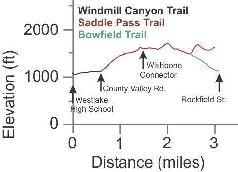
[12] Saddle
Pass Trail T2.5
![]() ,
T3
,
T3
![]() ,
T5
,
T5
![]()
 Description The
Saddle Pass Trails starts at the south end at County Valley Road across the
street from the Windmill Trail. It climbs up, quite steeply in places, ending
2.4 miles later near the top of a hill with views in every direction. The closest
parking is about 500' from the trailhead at the north end of Via Merida. The
trail starts off quite steep and narrow until you get past a few very tight
switchbacks whereupon it widens out. However, it continues up steeply and often
has a rut down the middle. Otherwise the tread is pretty firm and the trail
is a good width. It gets it's slightly higher technical rating of T2.5
Description The
Saddle Pass Trails starts at the south end at County Valley Road across the
street from the Windmill Trail. It climbs up, quite steeply in places, ending
2.4 miles later near the top of a hill with views in every direction. The closest
parking is about 500' from the trailhead at the north end of Via Merida. The
trail starts off quite steep and narrow until you get past a few very tight
switchbacks whereupon it widens out. However, it continues up steeply and often
has a rut down the middle. Otherwise the tread is pretty firm and the trail
is a good width. It gets it's slightly higher technical rating of T2.5
![]() because
of the steepness.
because
of the steepness.
About 0.8 miles from the start, the trail forks and continues
to the southeast. The well-used trail to the northwest climbs to the top of
the nearby hill to a spot with a great view all around. But continuing on the
mail trail to the southeast, it again forks about 350' further on. This time
the main trail takes a sharp bend to the northwest (the other direction will
take you to the top of the Aqiwo Trail). Another
fork to the right about 1.4 miles from the start leads to the top of another
hill and more outstanding views. This section of the trail has some exposure
and the trail is off-camber so it rates T3
![]() here. The last fork is 1.8 miles from the start. To the right (southeast)
is the Bowfield Trail while the Saddle Pass Trails continues straight north
and up an extremely steep T5
here. The last fork is 1.8 miles from the start. To the right (southeast)
is the Bowfield Trail while the Saddle Pass Trails continues straight north
and up an extremely steep T5
![]() hill. Be prepared for a real workout!
hill. Be prepared for a real workout!
Looking at the elevation profile below you can see that much
of the trail isn't very steep. Those sections rate T1.5
![]() .
.
There are no trees anywhere along the trail and so no shade. It gets very hot here during the warmer months so prepare accordingly.
Technical Rating T2.5
![]() ,
T3
,
T3
![]() ,
T5
,
T5
![]()
|
Length (miles) |
2.4 to the end; 1.8 only to the Bowfield Trail |
|
Climb (feet) |
900; 650 |
|
Descent (feet) |
420; 300 |
Trail Profile Back to the Top
 [13] Bowfield Trail T2
![]()
Description This short trail connects the Saddle Pass Trail to Rockfield Street. Across the street is the North Ranch Playfield and the start of the dirt path of the Lindero Creek Trail. From Rockfield St., it starts as a dirt path for 200 yards on the south side of Bowfield St, then climbs with a moderate slope up to Saddle Pass Trail. The tread is generally firm but may be a little rutted.
Technical Rating T2
![]()
|
Length (miles) |
0.6 |
|
Climb (feet) |
340 |
|
Descent (feet) |
Zero |
Trail Profile Back to the Top
 [14] Wishbone
Trail T2
[14] Wishbone
Trail T2
![]()
[14a]
Aqiwo Trail (AKA Wishbone Connector)
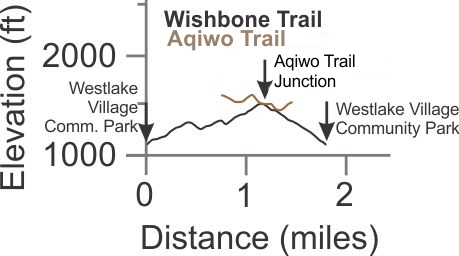
Description The Wishbone Trail is one of the newest trails in the Conejo Valley. Construction was started in the spring of 2018 and was completed about a year later after quite a number of volunteer events. It climbs towards the north-east from the very west end of the Westlake Village Community Park, loops around at the highest point and then comes down on the opposite side of the steep valley. The bottom ends are joined by a dirt path around the ballfields. It connects to the Saddle Pass Trail by way of a the Aqiwo Trail, a distance of 0.4 miles. (The Aqiwo Trail continues south and ends at a hill that overlooks the Community Park. This trail was formally named in May 2022 - "Aqiwo" means "Star" in the Chumash language.) There is no shade on either trail so it will be hot in the summer, but there could be lots of flowers in the spring, including mustard and other weeds that can choke the trail.
The Wishbone Trail is a bit steep for most mountain bikers to enjoy climbing.
Technical Rating T2
![]()
|
Length (miles) |
1.8; 0.4 miles from Wishbone to Saddle Pass Trail on Aqiwo |
|
Climb (feet) |
520; 150 to get to the Saddle Pass Trail |
|
Descent (feet) |
500; 70 to get to the Saddle Pass Trail |
Trail Profile Back to the Top
(climbing the northwest arm and descending the southeast arm):
 [15] Lindero
Creek Trail T1
[15] Lindero
Creek Trail T1
![]() ,
T2
,
T2
![]()
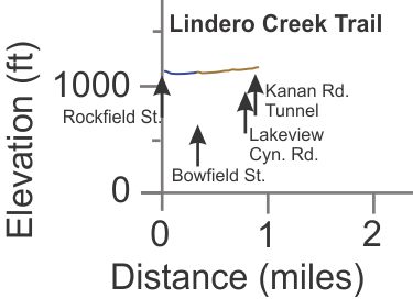
Description This short but beautiful trail is a hidden gem near the northeast corner of Thousand Oaks. There are two parts - in the south it is a decomposed granite (DG) path on the south and east side of the North Ranch Playfield. Crossing Bowfield St., it becomes a traditional trail that snakes through a beautiful stand of oak trees alongside Lindero Creek, crossing it a few times. Continuing north, it crosses Lakeview Canyon Rd., then goes through a tunnel under Kanan Rd. This tunnel is pitch black and is dangerous to traverse without a light because the surface is very uneven and could be full of debris and water.
There are temporary bridges across the stream but they could be removed in advance of stormy weather.
|
Length (miles) |
0.9 |
|
Climb (feet) |
80, south to north |
|
Descent (feet) |
50 |
Trail Profile Back to the Top
This page was last updated May 23, 2022.
|
|
Thanks for looking at Steve's guide to trails in Ventura County, the Santa Monica Mountains National Recreation Area (SMMNRA) and other locations. |
|