U.S. seeks national recreation area status for San Gabriels
The plan would improve access and boost security in joint management by the Forest Service and Park Service of the area, which provides 70% of L.A. County’s open space.
Source of this article: The Los Angeles Times, April 11, 2013
Interior Secretary Ken Salazar on Wednesday recommended designation of the San Gabriel River watershed and most of the San Gabriel Mountains as a national recreation area, making the popular playground eligible for additional law enforcement, interpretive signs, hiking trails, trash collection and other services.
Salazar’s long-awaited recommendation to Congress seeks to balance a crush of tourists with conservation. The designation would transform the 655,000-acre range, portions of the San Gabriel River and Rio Hondo corridors and Puente-Chino Hills into a unit of the National Park system co-managed by the National Park Service, federal officials said.
 The recommendation followed a decade of study and meetings with cities, environmental groups and recreational organizations, fire departments, flood control agencies and water districts laying claims on the watershed, which provides Los Angeles County with 70% of its open space and roughly 33% of its water.
The mountain range has free-flowing rivers, lush canyons and wrinkled slopes that are home to many rare and endangered species, including Nelson’s bighorn sheep, mountain yellow-legged frogs, Santa Ana suckers and Pacific pond turtles.
The range, which is managed by the budget-strapped U.S. Forest Service, is prone to fires and is visited by enormous weekend crowds that bring vandalism, drug deals, car burglaries, trash, illegal campfires and emergency rescues.
The proposal would encourage collaboration between the Forest Service and National Park Service. It strives to connect more communities east of Los Angeles with wild places and historical sites in their own backyards — and better manage the effects on natural resources.

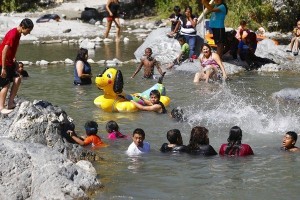
Visitors splash in the east fork of the San Gabriel River. The San Gabriel range, which is managed by the U.S. Forest Service, is prone to fires and is visited by enormous weekend crowds that bring vandalism, drug deals, car burglaries, trash, illegal campfires and emergency rescues.
Eventually, visitors could expect to see a greater presence of uniformed rangers, more access to river systems and perhaps even a bus line from San Gabriel Valley transit stops to high country wilderness, according to San Gabriel Mountains Forever, a group that has touted the proposal in community meetings and government hearings.
The region would operate as a component of the Santa Monica Mountains Recreation Area and would have an annual budget of about $2 million, said Martha Crusius, regional chief of planning for the San Gabriel Watershed and Mountains Special Resource Study.
“This recommendation is a major accomplishment for the San Gabriel Valley,” said former Labor Secretary Hilda Solis, who picnicked along the San Gabriel River as a child and went on to launch the campaign in 2003 to secure federal protections for the area. “These mountains and rivers are jewels, part of our collective heart and soul.”
Although the plan has yet to win approval, haggling has already begun over many details, including ways to ensure that waterways and groundwater aquifers are not diverted or polluted by increased fishing, boating, picnicking and swimming in what is already one of the most heavily used national forests in the nation.
The San Gabriel River ranks among the steepest rivers in the United States, plunging from its 9,900-foot-high headwaters to the ocean in about 70 miles. Five major dams control its flow, from boulder-strewn wild forks in the mountains to industrialized stretches in the flatlands below.
“Pollution of water supplies we depend on could be difficult and expensive to deal with,” said Adan Ortega, spokesman for the San Gabriel Valley Water Assn. “So, we’re seeking enabling legislation to protect water supplies and prevent customer rates from skyrocketing.”
Then there is the problem of what to call the new recreation area. “The high-profile name would probably have the words ‘San Gabriel’ in it,” Crusius said. “But that is a level of detail we are not planning for yet.”


0 Comments