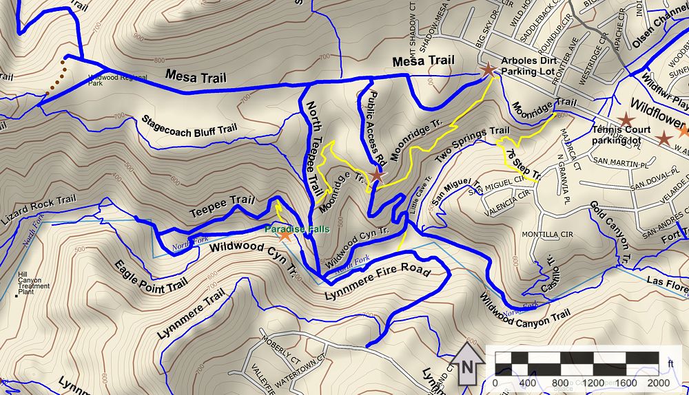
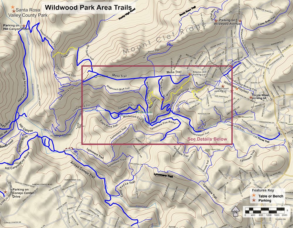
Trails of
Wildwood and Lynnmere Open
Space area Trails

Wildwood
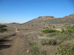
Mesa from the Lizard Rock Trail. The 400'-deep canyon is at the right.
|
Trails of Wildwood and Lynnmere Open
Space area Trails |
||
|
||
Wildwood is probably the most popular open space area in the Conejo Valley. If you are looking for quiet and few interactions with other outdoor enthusiasts, this area is not what you are looking for. But if you like to share your outdoor experience with others, have at it!
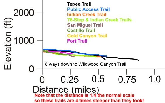
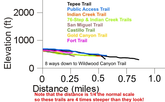
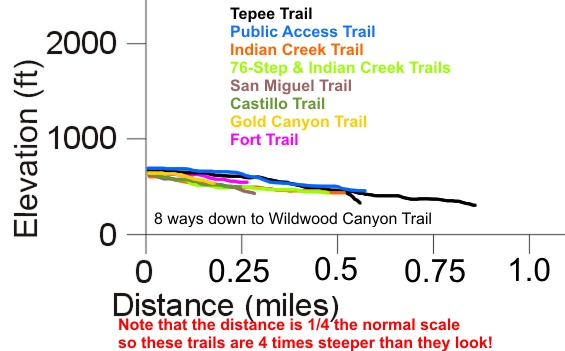
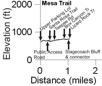
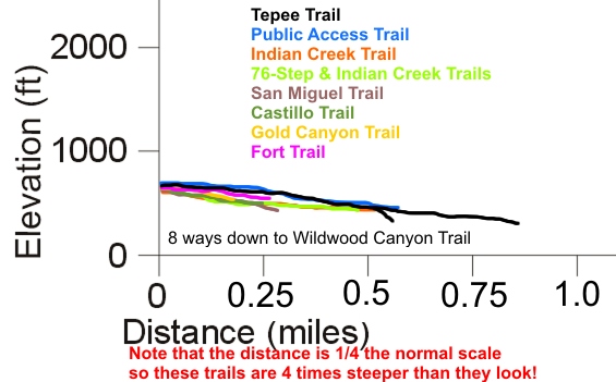
The predominant feature of Wildwood Park is the 400'-deep Wildwood Canyon. Most of the trails descend to the bottom, so you will get a workout returning to the top! There are nine trails that lead to the canyon from the plateau to the north of it. Except for Lizard Rock Trail, they are all less than a mile long, and are shown together on one elevation profile chart to make it easier to compare them. You'll find that they aren't very different from each other in terms of steepness. In generally, as you go west, the trails to the bottom get longer.
The most popular destination is Paradise Falls. On the way there or back, many people visit The Tepee, a permanent structure that provides some shade and a view into the canyon.
This is one area that clearly shows the volcanic past of the Conejo Valley. The rocks here are rugged, unyielding, and frequently show on the surface of the Stagecoach Bluff and Santa Rosa Trails. After a winter rain, Wildwood turns into super-sticky mud and takes a week or longer to dry.
|
|
Download the GPS tracks ![]() to help you find your way. This GPX file contains tracks for all the trails
in this area.
to help you find your way. This GPX file contains tracks for all the trails
in this area.
Box Canyon Trail
T2

Description This trail starts at very near the west end of Mesa Trail and descends to the south-west end of Rocky High Road in the Santa Rosa Valley. It starts at a broad dirt road at the top that is a little steep and loose. Once it passes a gas pipeline, it may continue as a dirt road, or may have overgrown to a doubletrack or even a singletrack, depending on the time of year. This trail is described more completely on the Santa Rosa Valley / Mount Clef web page. The Box Canyon Trail can be part of a loop route with the Santa Rosa Trail.
Technical Rating T2
|
Length (miles) |
1.0 |
|
Climb (feet) |
40 (Mesa Trail to Rocky High Road) |
|
Descent (feet) |
470 |
Trail Profile Back to the Top

Canyon
Overlook Trail T2.5
Canyon Overlook - Box Canyon Connector T5

Description The Canyon Overlook Trail consists of a dirt utility road that climbs up from Hill Canyon and a singletrack that connects the top of this road to the west end of the Mesa Trail. The singletrack was built during the Spring Trailwork Day in 2012 and provides access to the Conejo Canyons/Western Plateau from Wildwood. It can be part of a loop route that uses the Santa Rosa Trail or the Lower Santa Rosa Trail. Some of the singletrack has solid and rugged rocks, a reflection of the volcanic origins of the area. The utility road is a real grunt to climb on a mountain bike. It's steep and often has a scattering of loose rocks on the surface.
The Canyon Overlook - Box Canyon Connector trail
is an extremely steep 0.33-mile long trail, over which it drops 350 feet from
the Canyon Overlook Trail to the Box Canyon Trail. Because of the pitch, it
gets the highest technical rating of T5
.
It's best to avoid this trail!
Technical Rating T2.5
|
Length (miles) |
1.4 |
|
Climb (feet) |
250 (from Wildwood to Hill Canyon) |
|
Descent (feet) |
760 |
Trail Profile Back to the Top

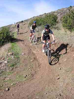
Castillo
Trail T2.5
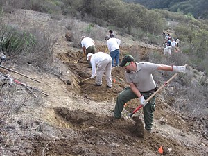 Description For
years, an unofficial trail led straight down the hill from the end of Castillo
Circle. During the Spring
Trailwork Day in March 2014, a proper trail was built. At right, you can
see volunteers working alongside a COSCA ranger, building the new trail. Like
so many others, it leads down to the Wildwood Canyon Trail.
Description For
years, an unofficial trail led straight down the hill from the end of Castillo
Circle. During the Spring
Trailwork Day in March 2014, a proper trail was built. At right, you can
see volunteers working alongside a COSCA ranger, building the new trail. Like
so many others, it leads down to the Wildwood Canyon Trail.
Technical Rating T2.5
|
Length (miles) |
0.25 |
|
Climb (feet) |
25 |
|
Descent (feet) |
150 |
Trail Profile Back to the Top
Eagle
Point Trail T2
Description This very pretty trail form a short loop with the Wildwood Canyon Trail from the Skunk Hollow picnic area to the Oak Grove picnic area. It starts under the oak canopy at the bottom of the canyon, climbs above it to the chaparral, then returns to the shade of the oak trees. It's open to all users, but it has some steps so it might not be the best choice for mountain biking.
Technical Rating T2
|
Length (miles) |
0.45 |
|
Climb (feet) |
150 |
|
Descent (feet) |
130 |
Fort Trail
T2
Description At one time, there was an imitation fort (from the wild west days) in the small park at the top of the Fort Trail, from which it derives its name. It was built in the 1960's as a promotion for the homes that were being built in the area and was torn down in 2009 after being surrounded by a chain link fence for years because it was falling apart. A little more than half way up, there's an access trail to San Andres Circle.
Technical Rating T2
|
Length (miles) |
0.3 |
|
Climb (feet) |
zero |
|
Descent (feet) |
110 |
Trail Profile Back to the Top
Gold
Canyon Trail T2.5
Description This trail seems to be less used than the others that lead down to the canyon; at least it's not as wide.
Technical Rating T2.5
|
Length (miles) |
0.17 |
|
Climb (feet) |
zero |
|
Descent (feet) |
110 |
Trail Profile Back to the Top
Las Flores Trail T2.5
Description This is a short trail that leads from the end of Wildwood Canyon Trail at the west end of Los Flores around the neighborhood houses to a gap between the houses across from Dillon Court. You can also access it from Lynn Road, but there's a steep bank to descend to get to the trail from Lynn.
Technical Rating T2
|
Length (miles) |
0.34 |
|
Climb (feet) |
15 (From the access across from Dillon Ct. to the W. end of Las Flores) |
|
Descent (feet) |
50 |
Little
Cave Trail (formerly Indian
Cave Trail) T2
Description This short trail of just over 100 yards heads north from Public Access Road just before it meets Wildwood Canyon Trail. There's a short and steep climb up to the Indian Cave.
Technical Rating T2
|
Length (miles) |
0.07 |
|
Climb (feet) |
20 (south to north) |
|
Descent (feet) |
Zero |
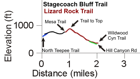
Lizard
Rock Trail T3

 Description This trail
is the most popular route for mountain bikers to get into the canyon so you
will see lots of them there. It starts at the west end of Mesa Trail with a
tough climb of 130' over about 1000'. At the top of the main trail is a
short spur that leads to the top of Lizard Rock, a good place for views in every
direction. From the spur to the top, the main trail heads down through a series
of switchbacks. The tread is a little rough here because it doesn't get much
maintenance and there could be loose rocks. Near the bottom, the trail splits
- the original trail heads north-east past the water treatment plant to connect
to the Wildwood Canyon Trail. To the south-west, a new
trail was cut during the Annual Trailwork Day in October 2015 that connects
to the west end of the Wildwood Canyon Trail on Hill Canyon Road.
Description This trail
is the most popular route for mountain bikers to get into the canyon so you
will see lots of them there. It starts at the west end of Mesa Trail with a
tough climb of 130' over about 1000'. At the top of the main trail is a
short spur that leads to the top of Lizard Rock, a good place for views in every
direction. From the spur to the top, the main trail heads down through a series
of switchbacks. The tread is a little rough here because it doesn't get much
maintenance and there could be loose rocks. Near the bottom, the trail splits
- the original trail heads north-east past the water treatment plant to connect
to the Wildwood Canyon Trail. To the south-west, a new
trail was cut during the Annual Trailwork Day in October 2015 that connects
to the west end of the Wildwood Canyon Trail on Hill Canyon Road.
Technical Rating T3
|
Length (miles) |
1.25 |
|
Climb (feet) |
130, all in the first 0.2 miles, starting at the Mesa Trail |
|
Descent (feet) |
550 |
Trail Profile Back to the Top (The trail profile is combined with the one for Stagecoach Bluff.)

Lower
Butte Trail T2
Description The Lower Butte Trail starts just north of the tennis courts at the west end of Wildflower park, heading north-east, and crosses Mount Clef Ridge to connect to the Santa Rosa Trail. This is another trail that can be used to make a route that goes in a loop. This trail is described more on the Santa Rosa Valley / Mount Clef web page.
Technical Rating T2
|
Length (miles) |
1.5 |
|
Climb (feet) |
430 (Wildflower Park to Santa Rosa Trail) |
|
Descent (feet) |
190 |
Trail Profile Back to the Top
Lynnmere Trail and Thistle Trail
|
|
Description In reality, Lynnmere is three distinct trails plus a connection (Thistle Trail) between the north and south branches. The elevation profile below is somewhat more complicated than most because of the trail connections. Let's walk through it. It might help to refer to the map at the top of this page while doing so.
Lynnmere starts at the west end at Wildwood Canyon Trail with a fireroad that crosses a stream then climbs up to Lynnmere Drive (black line on the elevation profile) in a gated community. The fireroad is a bit of a grunt on a bike and could be rutted. Shortly before you get to the top, singletrack trails come in from the left and right, the North Branch and South Branch, respectively. Let's go to the left and follow the North Branch to Lynn Rd. It goes up and down and turns a lot, but doesn't gain or lose much elevation by the end. The tread is mostly firm and not rocky. It's really fun on a bike and very popular for hiking. Half way to Lynn Road is a fork to the south, Thistle Trail. This connects to the South Branch.
Back near the top of the fireroad, the right trail is the South Branch of Lynnmere and it's quite different from the North Branch. Besides being longer, it has much more climbing and is quite rocky in sections and steeper. About 2 miles from Wildwood Canyon Trail, there's a fork to the right and downhill - the Calle Yucca Trail that leads to the Arroyo Conejo Trail in the canyon. The South Branch then crosses Calle Yucca (a street) and climbs to the top of a ridge. The trail drops into a saddle about 2.8 miles from Wildwood Canyon Trail where Thistle Trail comes into it on the left side. You can take the Thistle Trail back to the North Branch to make a loop that is entirely on dirt, or continue to Camino Magenta at the end, find your way to Lynn Road through the neighborhood, head north and get back onto the North Branch to get back to your start.
There aren't many trees or shade on these trails.
Technical Rating T1.5
 (Fireroad), T2
(North
Branch), T2.5
(South
Branch), T2
(Thistle
Trail)
(Fireroad), T2
(North
Branch), T2.5
(South
Branch), T2
(Thistle
Trail)
|
Length (miles) |
0.63 (Fireroad); 1.9 (North Branch); 2.7 (South Branch); 0.44 (Thistle Trail) |
|
Climb (feet) |
340; 400 (Fireroad to Lynn Rd); 780 (Fireroad to Camino Magenta); 200 (north to south) |
|
Descent (feet) |
25; 430; 640; 20 |
Trail Profile Back to the Top

Mesa Trail T1

 Description The Mesa trail is
a very easy fire road that is just over 1 mile long. Most trips
in the park start
on this road because it starts at the main parking lot and connects with the most common paths
into Wildwood canyon to the south, and the three to the north
towards the Santa Rosa Valley. From the main parking area, the trail heads straight
west up a small hill by the kiosk, then becomes a fireroad at the bottom of
the hill. It ends where the singletrack starts to climb up to Lizard Rock.
Description The Mesa trail is
a very easy fire road that is just over 1 mile long. Most trips
in the park start
on this road because it starts at the main parking lot and connects with the most common paths
into Wildwood canyon to the south, and the three to the north
towards the Santa Rosa Valley. From the main parking area, the trail heads straight
west up a small hill by the kiosk, then becomes a fireroad at the bottom of
the hill. It ends where the singletrack starts to climb up to Lizard Rock.
Technical Rating T1

|
Length (miles) |
1.1 |
|
Climb (feet) |
180 (From the main parking area to the Lizard Rock Trail) |
|
Descent (feet) |
80 |
Trail Profile Back to the Top
 Description This trail
is one of the few in the Conejo Valley that is closed to bikes and horses over
much of it's length. I presume that's because it has some stairs on it between
Public Access Rd and North Tepee Rd.
Description This trail
is one of the few in the Conejo Valley that is closed to bikes and horses over
much of it's length. I presume that's because it has some stairs on it between
Public Access Rd and North Tepee Rd.
The trail winds it's way from Majorca Court to the North Tepee Trail, passing the main parking area along the way (of course this is where most people will start and end). Across from the top of Indian Creek Trail is a short staircase that connects to Ave De Los Arboles. It is fairly level from Majorca Court until the main parking area, then it dips and climbs again when it emerges into the secondary parking area on Public Access Rd. From there it again dips down and climbs slightly to where it ends at North Tepee Trail at the west end.
Overall this is a pleasant hiking trail with no really steep hills (but some stairs) and firm tread. There are a few trees near the main parking area that provide some shade, but otherwise there's not much vegetation to block the view into the canyon.
|
Length (miles) |
1.3 |
|
Climb (feet) |
300 |
|
Descent (feet) |
300 |
Trail Profile Back to the Top

Public
Access Road T1
Description This dirt road starts at the Mesa Trail at the north, passes the secondary parking area and ends at the bottom of the canyon. It is one of the The Moonridge Trail crosses it about half way down.
Technical Rating T1
|
Length (miles) |
0.6 |
|
Climb (feet) |
15 |
|
Descent (feet) |
250 |
Trail Profile Back to the Top

San Miguel
Trail T2.5
Description This is another short trail that leads down to the Wildwood Canyon Trail, starting at San Miguel Circle.
Technical Rating T2.5
|
Length (miles) |
0.3 |
|
Climb (feet) |
zero |
|
Descent (feet) |
190 |
Trail Profile Back to the Top

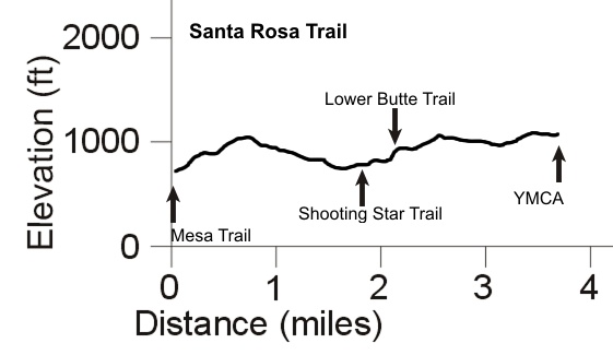
Santa
Rosa Trail T3.5

 Description The Santa
Rosa Trail runs 3.7 miles from Mesa Trail in Wildwood Park, up Mount Clef Ridge
and on to the Conejo Valley YMCA on N Moorpark Road. It is described on
the Santa Rosa Valley / Mount Clef
web page. It's rated at T3.5 because of a rocky and rutted series of switchbacks
where the trail climbs up and over to the north side of Mount Clef Ridge from
the Wildwood mesa.
Description The Santa
Rosa Trail runs 3.7 miles from Mesa Trail in Wildwood Park, up Mount Clef Ridge
and on to the Conejo Valley YMCA on N Moorpark Road. It is described on
the Santa Rosa Valley / Mount Clef
web page. It's rated at T3.5 because of a rocky and rutted series of switchbacks
where the trail climbs up and over to the north side of Mount Clef Ridge from
the Wildwood mesa.
Along with the Lower Santa Rosa Trail via the Shooting Star Trail, or the Lower Butte Trail, some great loop routes can be had from the Santa Rosa Trail that have amazing views into the Santa Rosa Valley. These other trails are described on the Santa Rosa Valley / Mount Clef web page.
Technical Rating T3.5
|
Length (miles) |
3.7 |
|
Climb (feet) |
600 (Wildwood to the YMCA) |
|
Descent (feet) |
300 |
Trail Profile Back to the Top
Description This trail starts on Velarde Drive and drops quickly to the Indian Creek Trail. It has a lot of steps. The tread is firm but it gets a higher technical rating because of the steepness. Like the top section of the Indian Creek Trail, it's closed to bikes and horses.
Technical Rating T3.5
HO
 (because of steepness)
|
Length (miles) |
0.15 |
|
Climb (feet) |
zero |
|
Descent (feet) |
130 |
Trail Profile Back to the Top

 Stagecoach
Bluff Trail T4
Stagecoach
Bluff Trail T4

Description This trail shows off the volcanic history of the area. Here the tread is composed of lava that has solidified to a very uneven surface. It's much more demanding than the largely parallel Mesa Trail. You can get a good view into Wildwood Canyon, and further west, into Hill Canyon where resides the water treatment plant. The east end starts from the Public Access Road and it ends to the west at the Mesa Trail near to the Lizard Rock Trail. This is a more interesting way to get to Lizard Rock than the Mesa Trail.
Technical Rating T4
|
Length (miles) |
0.75 |
|
Climb (feet) |
160 (East to west; from upper trail
on Upper Teepee) 230 (East to west; from lower trail on Upper Teepee) |
|
Descent (feet) |
80 |
Trail Profile Back to the Top (This trail is so short it's profile is combined with that of Lizard Rock.)
Tepee Trail
and North Tepee Trail T1
 Description As
the name suggests, this trail (actually a road) leads from the Mesa Trail to
The Tepee, which is a great place for a little break. If you haven't been here
before, you'll know The Tepee when you see it. Once at The Tepee, the road splits
and both forks continue down to Wildwood Canyon Trail. The east fork is much
shorter and steeper than the west fork shown to the right. Keep this in mind
when planning your route back to parking from the bottom of the canyon.
Description As
the name suggests, this trail (actually a road) leads from the Mesa Trail to
The Tepee, which is a great place for a little break. If you haven't been here
before, you'll know The Tepee when you see it. Once at The Tepee, the road splits
and both forks continue down to Wildwood Canyon Trail. The east fork is much
shorter and steeper than the west fork shown to the right. Keep this in mind
when planning your route back to parking from the bottom of the canyon.
Technical Rating T1
|
Length (miles) |
0.85 (with the west fork); 0.47 (with the east fork) |
|
Climb (feet) |
zero (starting at Mesa Trail); zero |
|
Descent (feet) |
370; 250 |
Trail Profile Back to the Top
Two Springs
Trail (formerly Indian
Creek Trail) T2.5
HO
T2
 Description This
trail has two distinct parts - the north end that drops quite steeply down to
the creek. It has a few steps and is closed to bikes and equestrians. At the
bottom, you walk along a rocky edge of the stream, then cross on stepping
stones. From there until it ends at Wildwood Canyon Trail, it's open to bikes
and horses. The photo at the right shows the lower section where it parallels
the creek - it's shaded and very pleasant.
Description This
trail has two distinct parts - the north end that drops quite steeply down to
the creek. It has a few steps and is closed to bikes and equestrians. At the
bottom, you walk along a rocky edge of the stream, then cross on stepping
stones. From there until it ends at Wildwood Canyon Trail, it's open to bikes
and horses. The photo at the right shows the lower section where it parallels
the creek - it's shaded and very pleasant.
|
Length (miles) |
0.5 (total length); 0.2 (steeper top section) |
|
Climb (feet) |
zero; zero |
|
Descent (feet) |
190; 100 |
Trail Profile Back to the Top
Wildflower
Park Trail T1.5
Description This very short trail of just over 0.3 miles runs along the north side of Wildflower Park and the west side of the tennis courts, connecting to Moonridge Trail in Wildwood Park by running through a tunnel underneath Avenida de los Arboles. You can park by the tennis courts and use the tunnel to get to the Moonridge Trail.
Technical Rating T1.5
Wildwood
Canyon Trail T2.5
 Description It's pretty much
impossible to travel any distance in Wildwood without covering at
least some of
this trail. It runs from Hill Canyon Road and the water treatment plant at the west end
to the terminus of Avenida de Las Flores at the east end, following the north fork
of the Arroyo Conejo. There are picnic grounds, water fountains and
even bathroom facilities; along the bottom of the
canyon is lots of shade provided by giant trees.
Description It's pretty much
impossible to travel any distance in Wildwood without covering at
least some of
this trail. It runs from Hill Canyon Road and the water treatment plant at the west end
to the terminus of Avenida de Las Flores at the east end, following the north fork
of the Arroyo Conejo. There are picnic grounds, water fountains and
even bathroom facilities; along the bottom of the
canyon is lots of shade provided by giant trees.
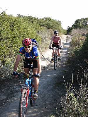
There are several steam crossings with bridges most of the year, but they are removed in the winter so they don't get swept away in the storms. A favorite place for a snack is at the picnic table next to Paradise Falls (photo at right). The prettiest part to trail is the section between Indian Creek Trail and Fort Trail, before it climbs out of the canyon and the trees thin out. In general this is an easy trail and is suitable for everyone.
Most of the trail is an easy dirt singletrack or fireroad with a very gentle grade, but there is one steeper section where the trail climbs above Paradise Falls and it becomes rocky, but the rocky section is only about 100 yards long.
Technical Rating T2.5
|
Length (miles) |
2.2; Including Las Flores Trail, 2.5 |
|
Climb (feet) |
460 (Traveling west to east); 570 |
|
Descent (feet) |
210; 225 |
Trail Profile Back to the Top

Zinnia Trail
T1
Description This trail runs parallel to the south-west end of the Lower Butte Trail, but on the other side of a large drainage ditch. It is a dirt road and connects to the cul-de-sacs on Azelea Street and Zinnia Court.
Technical Rating T1
|
Length (miles) |
0.2 |
|
Climb (feet) |
25 (heading north-east) |
|
Descent (feet) |
zero |
Trail Profile Back to the Top
This page was last updated July 28, 2023.
|
|
Thanks for looking at Steve's guide to trails in Ventura County, the Santa Monica Mountains National Recreation Area (SMMNRA) and other locations. |
|