Overview
of adjacent areas
|
Trails of
Arroyo Conejo Open
Space area Trails
|
|
|
|
|
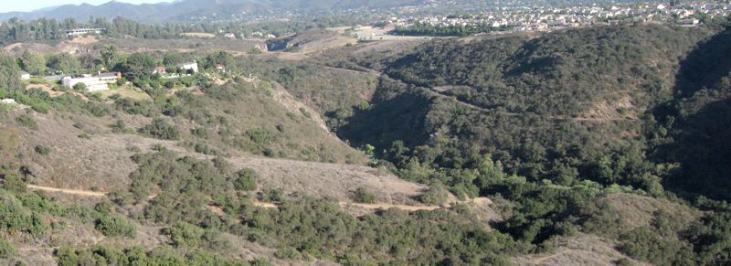
Looking
south-east from the Lynnmere trail into the Arroyo Conejo. The Calle
Yucca Trail is in the foreground and the Arroyo Conejo Trail in
the background, both descending into the canyon.
|
Overview
This web page is under construction.
Please check back in a few days, weeks or months to see if it's
ready. Thanks! (Tte descriptions are lacking, but the maps are finished.)
This area encompasses
Official
Websites

Trailheads
a. Main parking at Rancho Conejo Playfields. Map
and directions.
b. Calle Yucca. Map
and directions.
c. Calle Arroyo, in a gated community.
d.
Calle Arroyo. Map
and directions.
e. Citation Way. Map
and directions.
y. Hill Canyon wastewater treatment plant.
z.
Rancho
Conejo Playfields.
Trails
[1] Arroyo Conejo TrailDescription This trail
has two major components, a single track trail that winds around the Rancho
Conejo Playfields, and a fireroad that descends to the bottom of the canyon
and leads to the waste water treatment plant.
The single track starts at the parking area for the Rancho Conejo
Playfields. There are some unofficial side trails that lead to overlooks of
sorts. The trail becomes considerably steeper when it joins the fireroad, until
the bottom of the canyon, where the stream crosses the fireroad a number of
times; depending on the amount of water in the stream and if there are any stepping
stones (and if you want to get your feet wet), you may not be able to get across
the stream. The fireroad leads to a constructed wetland area at the north-west
end, where a small spur crosses the stream for a final time to join the Baxter
Fireroad. Again, you may not be able to get across the stream without getting
your feet wet.
Where the fireroad first comes to the bottom of the canyon,
the Calle Yucca Trail forks off and climbs up to the Lynnmere
Trail.
Download the GPS track  to help you find your way.
Technical Rating
|
Length (miles)
|
2.4 |
|
Climb (feet)
|
125 (from the Rancho Conejo Playfields
to the north-west end) |
|
Descent (feet)
|
460 |
Trail Profile Back to
the Top
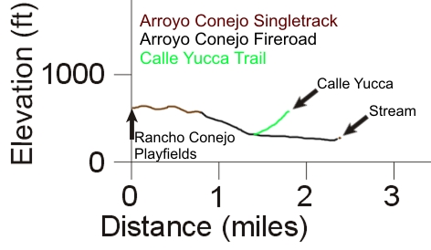
[2] Calle Yucca TrailDescription This
Download the GPS track
to help you find your way.
Technical Rating
|
Length (miles)
|
0.4 |
|
Climb (feet)
|
270 (From the Arroyo Conejo Trail to Lynnmere
Trail) |
|
Descent (feet)
|
10 |
Trail Profile Back to
the Top
(Profile is combined with that for the Arroyo
Conejo Trail.)
[3] Arroyo
Conejo Trail South
Description This is a short but moderately steep climb
up to Lynnmere Trail from
the Arroyo Conejo Trail.
Download the GPS track
to help you find your way.
Technical Rating
|
Length (miles)
|
|
|
Climb (feet)
|
|
|
Descent (feet)
|
|
Trail Profile Back to
the Top
This page was last updated September 8, 2017