|
Trails of
Point Mugu State
Park
|
|
|
|
|
|
|

View from one of the ridges, looking north up Sycamore Canyon,
with Boney Mountain in the background
|
Overview
As of the beginning of January
2015, Pt Mugu State Park was completely closed due to mudslides caused by heavy
December Rains. The park remained closed for about a month while mudslides were
cleared from trails and parking areas.
The La
Jolla Canyon Trail was completely washed away
at the waterfall and is expected to be closed for about a year. No work can
start on rebuilding the stairs past the waterfall and otherwise repairing the
trail until the canyon walls stabilize and rocks no longer fall from it. Storms
in early 2016 may delay repair work to the trail. As of March 2017, the
La Jolla Canyon Trail is still closed and there is no anticipated date for it
to re-open. The heavy rains we had over the winter further damaged the trails
and loosened boulders on the canyon walls, increasing the hazard of landslides.
For your own safety, please stay out of La Jolla Canyon!
There are some great trails around Thousand
Oaks and the Conejo Valley, but many people consider Sycamore Canyon in
Point Mugu State park
to be the best, especially for novice and intermediate users. It
has a great variety of single tracks and fire roads with a variety
of degrees of difficulty, but none of them are really rocky, loose
or rutted. It is secluded so you don't see any development, and
there are lots of trees to provide shade and beauty. It can get
hot here in the summertime, especially on the trails that climb
out of the
cayon, but it's still one of the least hot places to ride and hike.
In the canyon there are trees and shade, but up on the higher trails
there are great views.
Sycamore Canyon trails are very accessible. There is plenty
of free parking at the top (north end) at the two trailheads, and ample paid
parking in the campground at the bottom. For people who would like only a short
and/or easy hike, the Sycamore Canyon Fireroad from the campground and the Satwiwa
area at the north end provide lots of choices.
On the other hand, the trails of the Boney Mountain Wilderness
are more suited for good hikers. The trails are longer, steeper and sometimes
rocky or rutted, but more secluded, and with fantastic views of nearby
valleys and distant peaks. All trails in the Wilderness Area, east of Sycamore
Canyon Fireroad, are closed to bikes.
One unique feature of Sycamore Canyon is the availability
of plumbed facilities. There are indoor bathrooms at or near each
end of the main Sycamore Fire Road and outhouses in three places
on that trail and one (sometimes) in Wood Canyon not far from the
bottom of Hell Hill. Also, there are several fire hydrants that
are outfitted with spigots so you can refill your water bottles.
Point Mugu State Park can be thought of as three distinct sections:
La Jolla Canyon, Sycamore Canyon and the Boney Mountain Wilderness Area. La
Jolla Canyon is not described here because it has a web page and map of it's
own. North of the state park is Rancho Sierra Vista (managed by the Santa
Monica Mountains Conservancy) and Satwiwa (National Park Service). The agencies
that manage these open spaces are to be
commended for providing a excellent outdoor recreational area, especially for opening several beautiful single
tracks in late 2002 that were previously closed to mountain bikers.

Official Websites
Trailheads
a. Main entrance to Rancho Sierra Vista/Satwisa. Turn south from Potrero
Rd, across from Via Goleta. Map
and directions to the entrance
b. Potrero Road at the south end of Wendy Drive.
Map
and directions
c. Sycamore Canyon Campground off of the Pacific
Coast Highway. Map
and directions
d. Serrano Road, off of Pacific View Drive. Map
and directions
e. La Jolla Canyon Trailheads, off of the Pacific
Coast Highway. Map
and directions
Geocaches in the area
Trails
[1,2]
Sycamore Canyon Fire Road and Wendy Connector Single Track  Description The Sycamore Canyon
Fire Road winds through the bottom of Sycamore Canyon from Newbury
Park to the Pacific Coast Highway. Much of the canyon floor
is covered with giant sycamore and oak trees. Because of the gentleness
of the slope when you start from the PCH end, it is very popolar
with people looking for an easy walk, with novice bikers, and
even parents pushing baby strollers. The only hazards are the stream
crossings of which there are about a half dozen near the south
end of the trail. Most of the year there is at least a little water
in the stream so people can expect to get their feet wet.
Although the road goes all the way to Potrero Road
on the north end, we always start at the Wendy trailhead and take
the connector trail (it used to be a single track but it is so popular
that it has become a double track) that joins the main trail about
a quarter mile from Potrero Road. The first section is paved. Riding
south, you pass a ranger house on the left side, then the Satwiwa
Indian Cultural Center. There are real bathrooms here so this is
a popular place to stop.
After climbing a small rise you will find yourself
at the top of the "Blacktop Hill" where you can enjoy
the view into the canyon and rest on a park bench (dedicated to
the memory of a mountain biker who suffered a heart attack pedalling
up the Blacktop Hill). Be careful to watch your speed going
down this hill; there are sharp corners, lots of people, and occasionaly
you will encouter vehicles on the road. At the bottom of the hill
the slope is gradually downhill to the campground at the PCH. There
is one short section of single track in the middle which is joined
by the Sin Nombre Trail. If you stay on the road, you will pass
a house on the left, then the road will bend sharply right, go through
a stream bed, and come into a junction. The road continues to the
left. Straight ahead is the Ranch Center Fire Road and to the right
is the end of the single track section. From here to the beach,
the road is dirt instead of pavement. At the south end of the trail
is a state campground with indoor bathroom facilities. It is a short
dash across the PCH to the beach - a good place for a snack and
a rest before heading back to Newbury Park.
Sycamore Canyon Fire Road is perfect for novice
riders. For better riders, there are a number of trails that join
it that head to the ridgelines to the west and provide lots
of climbing and descents.
Download the GPS track  to help you
find your way.
All trails that head east from Sycamore Canyon are
closed to bikers because they lead into the ajoining wilderness
area.
Technical Rating Sycamore Canyon Fireroad: T1.5
 ;
Wendy Connector: T2

|
Length (miles)
|
8.9 |
|
Climb (feet)
|
570 |
|
Descent (feet)
|
1400 |
Trail Profile Back
to the Top

|  Wood Canyon Fire Road
|
[3,7]
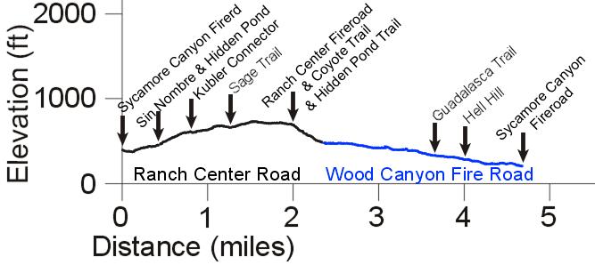
Ranch Center Road and Wood Canyon Fire Road
Description Wood Canyon is one
of the most fun and popular trails in Sycamore Canyon. Although
technically a fire road, no vehicles drive on it and it is only
plowed out every few years, so most of the time it is more like
a double track. There are several stream crossings that are great whoop-de-doos
later in the year when they are dry, and even when they have water
in them, but they can make tacos of your wheels when they are muddy.
Wood Canyon is also a gateway to Overlook
Fire Road via Guadalasca Trail, the
easiest way up, and Hell Hill, the hardest
way unless you walk.
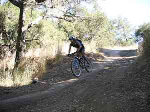
|  Ranch Center Road, in front of Coyote Trail, with Wood Canyon in
the background
|
Ranch Center Road is a paved road that starts at
Sycamore Canyon Fire Road and climbs steadily (and quite steeply
for novices). Although shunned by some because it is a road and
they prefer the Sage Trail single track to get
to Wood Canyon, others find it to be very peaceful. It has
no vehicular traffic and it crosses some broad meadows. In
the spring the meadows are especially beautiful when they are full
of wildflowers. It doesn't take much concentration to climb this
road so you have lots of time to look around and enjoy the surroundings.
The same can't be said of Sage Trail.
Download the GPS track  to help you
find your way.
Technical Rating Ranch Center Road: T0
 ;
Wood Canyon Fireroad: T1.5

|
Length (miles)
|
4.7 |
|
Climb (feet)
|
590 |
|
Descent (feet)
|
770 |
Trail Profile Back
to the Top
 [4]
Sin Nombre Single Track
 Description The Sin Nombre trail
is a really pretty, fun and easy single track that was newly opened
to bikers in late 2002. It is one of three trails that leads to/from
Ranch Center Road and the easiest to ride up because it has the
least climbing (but comes into the lower part of Ranch Center Road).
Download the GPS track  to help you
find your way.
Technical Rating T2.5

|
Length (miles)
|
0.9 |
|
Climb (feet)
|
150 |
|
Descent (feet)
|
70 |
Trail Profile Back
to the Top

[5] Sage
Single Track Description The Sage Trail is
a slightly rocky, slightly rutted single track that climbes steadily
from the Ranch Center Fire Road (about 100 feet from the bottom
where it joins Sycamore Canyon Fire Road) to the paved Ranch Center
Road. Novices will find it's much easier to ride up Sin Nombre Trail
or Ranch Center Fire Road if they want to Ranch Center Road so they
can ride down Wood Canyon.
Download the GPS track  to help you
find your way.
Technical Rating T3.5

|
Length (miles)
|
0.75 |
|
Climb (feet)
|
370 |
|
Descent (feet)
|
25 |
Trail Profile Back
to the Top
[6]
Ranch Center Fire Road
Description The Ranch Center
Fire Road starts at the Sycamore Canyon Fire Road and ends at Ranch
Center Road right next to the water tower. It is fairly smooth and
firm so it's easy to ride up for novices, but it is quite steep
for the last 20% so some pushing might be required.
Download the GPS track  to help you
find your way.
Technical Rating T1.5

|
Length (miles)
|
1.0 |
|
Climb (feet)
|
400 |
|
Descent (feet)
|
Zero |
Trail Profile Back
to the Top
[8]
Two Foxes Single Track
Description This is one of the
trail that was opened to bikes near the end of 2002, and what a
great trail it is! It runs parallel to Sycamore Canyon Fireroad,
but on the west side of the stream, winding through the trees and
over the stream a couple of time. The hills are pretty gentle with
very short steeper sections to get out of the streambed. Two Foxes
also give access to the south end of Coyote trail about half way
through.
Download the GPS track  to help you
find your way.
Technical Rating T2

|
Length (miles)
|
1.0 |
|
Climb (feet)
|
190 (riding from the south end) |
|
Descent (feet)
|
120 |
Back
to the Top
[9] Coyote
Single Track
Description This trail was mistakenly
reported to be
open to mountain bikers in late 2002, but it remains closed. That's
a shame because from the top there are spectacular
views into Wood Canyon and Sycamore Canyon. If you happen to be
in the vicinity and have left your bike behind, it's well worth
hiking.
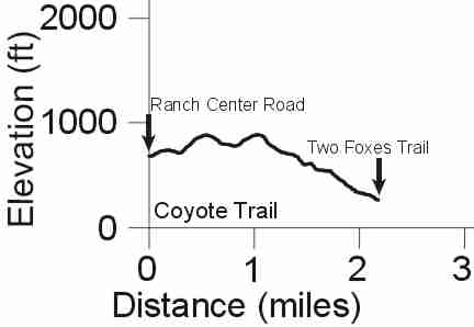
The trail starts at
the north end near the end of Ranch Center Road where it intersects
with Ranch Center Fire Road, but on the other side of the water
tower. The trail has two sections. The northern half is unimproved
and a little overgrown. It has some very steep climbs
when hiking south, and a couple of short, loose downhills sections.
On the other hand, the southern half has been improved to modern
multi-use standards and so is wider and less steep, except for one
or two rocky and sharp switchbacks. The upper part of this section also has
some fantastic views.
Download the GPS track  to help you
find your way.
Technical Rating NB
 T2.5
T2.5

|
Length (miles)
|
2.25 |
|
Climb (feet)
|
410 (starting at the north end) |
|
Descent (feet)
|
840 |
Trail Profile Back
to the Top
[10]
Guadalasca Single Track (AKA Guadalasco*)
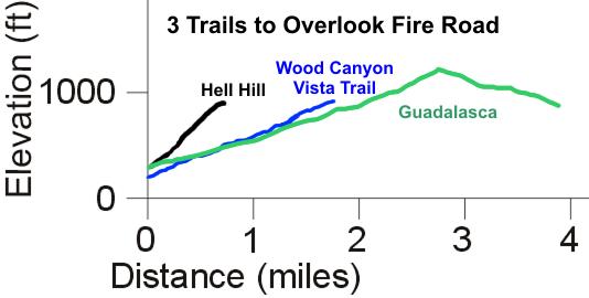
 Description There are three
ways to climb up to the Overlook Fire
Road from the canyon. Guadalasca is the easiest. As shown in
the profile below, Guadalasca is less steep than Wood
Canyon Vista Trail and less than half as steep as Hell
Hill. Besides being the easiest way up, it is also the prettiest
because there is more green vegetation and it is the coolest in
the summertime as it is completely on a north-facing slope.
If those aren't enough reasons, when you get to the top, North Overlook
has a really fun descent that you will miss with the other routes.
Guadalasca Trail starts in Wood
Canyon and ends at the top of Hell Hill.
The upper 1.3 miles of this trail used to be part of the Overlook Fireroad,
but in 2011, State Parks abandoned it as a road and started to allow it to narrow
down to a singltrack trail. Download the GPS track  to help you
find your way.
*The sign at the top of this trail calls it "Guadalasco"
but other signs and all the maps from the park agencies call it "Guadalasca."
Technical Rating T2.5

|
Length (miles)
|
3.9 |
|
Climb (feet)
|
950 |
|
Descent (feet)
|
400 |
Trail Profile Back
to the Top
[11]
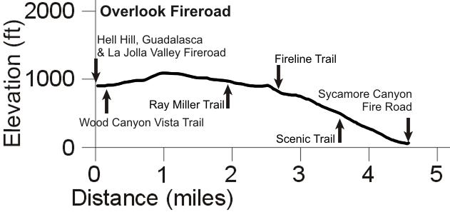
Overlook Fire Road  Description This rider (Steve)
thinks this is the best trail in Sycamore Canyon for mountain biking, although some
people poo-poo it because it is not a single track. In fact, that's
part of its attraction. The road starts in the north at the top
of Hell Hill and continues south to the Sycamore Canyon Fire
Road about a half mile from the campground and less than a mile
from the beach. A couple hundred yards or so past the top of Hell
Hill is the Wood Canyon
Vista Trail back down to the canyon. Continuing along, the road runs parallel to
the ridge that separates Sycamore Canyon from La Jolla Valley. At
some point the road crosses over the ridge so there are great views
into the valley and of the ocean below, ahead and to the right.
Further along there are views from the east side of the ridge down
into Sycamore Canyon and the ocean is ahead and to the left. The
descents here are really fun: long enough to pick up a little speed,
slightly rocky for a bit of a challenge, and wide enough to easily
go around any hikers or horses that are sharing the road (please
slow down to a crawl when passing horses - you don't want to startle
them so they throw their riders. Also,
a number of hikers and trail runners like to listen to music
players so don't count on them hearing you coming). Be careful at
the ends of the downhills because some of them end in very sharp
corners with a serious lack of horizontal ground beyond their
edges. When you get to a section where the road is composed of solid
white rock, you are approaching a left-hand switchback that signals
the final descent. From here the road is very firm but often has
some ruts crossing it that are good for high-speed bunny hops
(don't have clipless pedals yet? Get them!) and there are a
few more switchbacks before you get back to Sycamore Canyon Fire
Road. From here it's less than a mile to the beach. On the way back,
you can go up the Overlook trail to get some great exercise and
also you won't see any baby strollers.
Download the GPS track  to help you
find your way.
Technical Rating Overlook:
T1.5

|
Length (miles)
|
4.4 |
|
Climb (feet)
|
550 |
|
Descent (feet)
|
1400 |
Trail Profile Back
to the Top
[12] Hell Hill (Overlook
Fire Road)
|  Struggling up Hell Hill
|
Description Of the three trails
up to Overlook Fire Road, Hell Hill
is by far the hardest. It is at least twice as steep as the other
two ways. Not only is it steep, it is in the bottom of a canyon
so when the sun is shining, it reflects from the canyon walls and
so beats down doubly hard. Sometimes the road is well packed and
fairly smooth, but after the winter rains it becomes severely rutted.
When that happens, the Park Service will grade it so it becomes
incredibly loose and then in takes months to pack down well. People
can ride up it if they are in excellent shape, but don't try it
without a rest unless you want to risk a heart attack and die. Even
though it's steep, it's the fastest way for novices to walk to the
top. It's also the fastest way down if you're in a hurry to get
back.
Note: The Hell Hill fire road continues past
Overlook Fire Road into La Jolla Valley. Called La
Jolla Valley Fireroad, it is open to bikes, but only until the wooden bridge,
1.0 miles in. Don't ride any further!
Download the GPS track  to help you
find your way.
If you think this trail is steep, see
how it compares to other steep trails.
Technical Rating T1.5

|
Length (miles)
|
0.75 |
|
Climb (feet)
|
620 |
|
Descent (feet)
|
Zero |
Trail Profile Back
to the Top
|

This photo was taken from a spot where the trail loops back below
it.
|
[13]
Wood Canyon Vista Trail (Backbone Trail)
Description This trail is much
easier than Hell Hill for getting to
Overlook Fire Road but a little more difficult than Guadalasca.
It is slightly more steep and significantly more rocky. Nevertheless,
for intermediate riders, it is equally enjoyable and provides some
great views of Sycamore Canyon below. It's also great fun to go
down it. Unlike the other two routes up, this trail starts from
the Sycamore Canyon Fire Road, less
than a quarter mile south of the junction with Wood
Canyon Fire Road.
Download the GPS track  to help you
find your way.
Technical Rating T3

|
Length (miles)
|
1.8 |
|
Climb (feet)
|
740 |
|
Descent (feet)
|
Zero |
Trail Profile Back
to the Top
[14]
Sycamore-Los Robles Connector Trail
Description This short single
track starts at the Wendy trailhead (about 2/3 of the way to the
creek crossing), runs parallel to Potrero Road and comes out across
the street from the west end of Los Robles Trail. It's much more
fun to ride on this single track than on Potrero Road.
Download the GPS track  to help you
find your way.
Technical Rating T2

|
Length (miles)
|
0.6 |
|
Climb (feet)
|
140 |
|
Descent (feet)
|
10 |
Back
to the Top
[15] Satwiwa Area
 Description: The Satwiwa
Native American Indian Cultural Center and Natural Area was established by
the National Park Service to display the heritage of the Chumash people who lived nearby.
There is a Native American guest host or Park Ranger on the weekends to answer
questions at the cultural center next to the demonstration village.
The area is mostly grassland on gently rolling hills, although the trails
in the south-west corner are steep enough to have steps. There are several trails
that have wide and firm tread and great views of Boney Mountain to the south.
This is a great place for an easy stroll with the family. Horses and bikes
are not allowed on these trails. The map below shows these trails in more detail.
The photo shows the Satwiwa area as seen from above on the Hidden Valley
Overlook Trail. Sycamore Canyon Fireroad runs down the middle, left to right.
Download the GPS track  to help you
find your way.
Technical Rating HO
 T2
T2


Back
to the Top
[16] Fireline Trail
Description: This singletrack trail winds down from Overlook Fireroad
to the main Sycamore Canyon Fireroad. It is quite similar to the Wood Canyon
Vista Trail except it's a little narrower because it's not as well used.
Download the GPS track  to help you
find your way.
Technical Rating NB
 T3
T3

|
Length (miles)
|
1.4 |
|
Climb (feet)
|
800 |
|
Descent (feet)
|
80 |
Trail Profile Back
to the Top

[17] Scenic and Great Dune View Trails
Description: The description will be coming soon!
Technical Rating NB
 T3
T3

|
Length (miles)
|
0.75 |
|
Climb (feet)
|
430 |
|
Descent (feet)
|
0 |
Trail Profile Back
to the Top
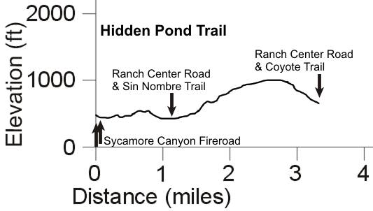
[18] Hidden Pond Trail
Description: The Hidden Pond Trail provides a less travelled alternative
to the main roads for getting around the north-west section of Sycamore Canyon.
It starts near the bridge at the bottom of the blacktop hill on Sycamore Canyon
Fireroad. The first few hundred yards is a little rocky as in sections where
it runs through the streambed. However, this section can be avoided by another
short access trail about 300 yards further down the road. Beyond the streambed
the trail gets a little steeper and some sections have a trench in the middle
from horse wear. The trail has two connectors to Ranch Center Road (one not
shown on the map comes out across from the Kubler Connector), climbs a steep
hill with some tight switchbacks, then eventually comes out on Ranch Center
Road across from Coyote Trail at the water tank.
Download the GPS track  to help you
find your way.
Technical Rating NB
 T3
T3

|
Length (miles)
|
3.3 |
|
Climb (feet)
|
1000 (going east to west) |
|
Descent (feet)
|
800 |
Trail Profile Back
to the Top
[19] Closed trails
Description: As of early June 2010, Art's Trail and it connectors have been closed. Barriers
have been errected to keep people off. See this
CORBA blog entry for more information.
Back
to the Top
[20] Hidden Valley Overlook Trail
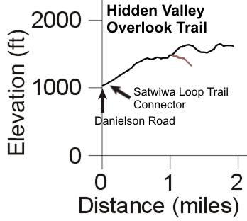
 Description: This
trail climbs to provide some great views of Satwiwa, Rancho Potrero, Hidden
Valley and the north flank of Boney Mountain. It starts with a moderately steep
climb from Danielson Road. The trail here is rocky and rutted but firm. The
trail levels out and becomes smoother as it goes through a meadow, then it splits.
The north fork is very steep and loose at first, then continues as a ridgeline
fireroad that has views on both sides into Hidden Valley. There are a few forks
towards the east end that wind down into private property.
The south fork (singletrack) at the east end of the meadow, shown in brown
on the elevation profile below, drops steeply to a broken gate, beyond which
there is access to a trail that skirts south and above Hidden Valley. The trail
on this map ends at the broken gate.
The photo shows the view west down the trail to see Rancho Potrero and
homes in Dos Vientos.
Download the GPS track  to help you
find your way.
Technical Rating NB
 T2.5
T2.5

|
Length (miles)
|
1.9 (to north-east end) |
|
Climb (feet)
|
840 |
|
Descent (feet)
|
260 |
Trail Profile Back
to the Top
[21] Danielson Road (AKA
Old Boney Trail)
Description: The Danielson Road provides access to the old cabin and
Danielson memorial from the main Sycamore Canyon Fireroad. It starts just above
the long paved hill on Sycamore Canyon Fireroad and skirts the south edge of
Satwiwa. The trail along the initial moderate climb then drop into Upper Sycamore
Canyon is firm but somewhat rutted. In the canyon, it crosses the stream and
them switches back to head west. At this point there is a short spur that leads
to a pretty and popular waterfall. Danielson Road climbs up the north flank
of Boney Mountain with changing views into Sycamore Canyon and of Boney Mountain.
On the way to the old cabin site, the Old Boney Trail forks off on the right
side.
Danielson Road is quite popular because it provides easy hiking access
to the waterfall, the old cabin and memorial site, and Old Boney Trail. Download the GPS track  to help you
find your way.
Technical Rating NB
 T2
T2

|
Length (miles)
|
2.3 (Sycamore Canyon Road to the old cabin site) |
|
Climb (feet)
|
800 |
|
Descent (feet)
|
200 |
Trail Profile Back
to the Top

[22] Upper Sycamore Trail
Parts of this trail were washed away in the heavy rains
of late December, 2014. It is expected to be closed for a few months until it
is repaired.
Description: The Upper Sycamore Trail leads from the base of the paved
hill on Sycamore Canyon Fireroad (just over the bridge at the port-a-pottys)
to Danielson Road. It is pretty singletrack with several easy stream crossings.
It is a much prettier way to get into or out of Sycamore Canyon, compared
to the paved Sycamore Canyon Fireroad. Keep in mind, though, that it is a somewhat
longer journey.
Download the GPS track  to help you
find your way.
Technical Rating NB
 T2.5
T2.5

|
Length (miles)
|
1.3 |
|
Climb (feet)
|
450 |
|
Descent (feet)
|
50 |
Trail Profile Back
to the Top

[23] Old Boney Trail

The
Old Boney Trail winds along the western flank of Boney Mountain
 Description: The
Old Boney Trail must be the crown jewel of the Boney Mountain Wilderness Area.
The trail climbs, drops and winds around, providing tremendous and constantly
changing views of Boney Mountain, Sycamore Canyon, La Jolla Canyon, the Channel
Islands and more. There are several trails that connect it to Sycamore Canyon,
Serrano Valley and Circle X
Ranch so there are many options for hiking. The segment between the Blue
Canyon and Charmberlain Trails is part of the Backbone Trail.
Much of the trail goes through tall chaparral that provides some shade and
adds to the feeling of isolation (although you can expect to pass several people
whenever you hike here). The trail width depends on how recently volunteers
have been through to work on the trail, but it is always easily passible. The
tread is generally quite smooth and firm, but there are some sections that are
more rocky and rutted.
Download the GPS track  to help you
find your way.
On the ridge about a half mile south of Fossil Trail, there is an indistinct
trail that leads up to a number of boulders that have fallen from the cliffs
above. This is a good place to take in the view while having a snack or lunch.
Technical Rating NB
 T2.5
T2.5
 to T3.5

|
Length (miles)
|
6.7 |
|
Climb (feet)
|
1600 (north to south) |
|
Descent (feet)
|
2800 |
Trail Profile Back
to the Top
[24] Fossil Trail
 Description: This well-travelled
trail leads from the Upper Sycamore Trail, starting only about 400 feet from
Sycamore Canyon Fireroad. It climbs, and in places it is very steep, up to the
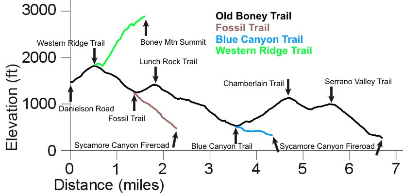
Old Boney Trail. It gets its name from the fossils in the rocks in the middle
of the trail about 2/3 of the way to the top. The elevation profile is shown above with that of
the Old Boney Trail.
Download the GPS track  to help you find
your way.
Technical Rating NB
 T3
T3

|
Length (miles)
|
0.9 |
|
Climb (feet)
|
850 |
|
Descent (feet)
|
70 |
Trail Profile Back
to the Top
[25] Blue Canyon Trail
Description: The Blue Canyon Trail leads from the east end of the
Danielson Multiuse Area up to the Old Boney Trail. It is part of the Backbone
Trail. It provides the gentlest
climb up to the Old Boney Trail and is very pretty. It starts with a very gentle
and shaded
climb from Sycamore Canyon and becomes a little steeper and less shaded as it
approaches Old Boney Trail.
Download the GPS track  to help you find
your way.
Technical Rating NB
 T2
T2

|
Length (miles)
|
0.83 |
|
Climb (feet)
|
270 |
|
Descent (feet)
|
90 |
Trail Profile Back
to the Top
[26] Chamberlain Trail
 Description: The
Chamberlain Trail, part of the Backbone Trail, connects the Circle X Ranch
area to the Boney Mountain Wilderness. It starts at the convergence of the Mishe
Mokwa and Sandstone Peak trails in Circle X Ranch and runs 3.6 miles, mostly
downhill, to the Old Boney Trail. The top section of the trail runs through
a broad mesa covered in chaparral and grass, and then drops with moderate steepness
along a ridgeline to the Old Boney Trail. For the most part, the tread is very
good although there are rocks and ruts in some of the steeper spots. The
views are great into Serrano Valley, Sycamore Canyon, La Jolla Valley and beyond
when facing west, and of the cliffs of Boney Mountain when facing east and north.
Often the view is obscured by tall chaparral that also protects the trail along
the ridgeline from some steep drops on both sides.
Download the GPS track  to help you find
your way.
The photo at right shows the Chamberlain Trail split rock, with a view of
Serrano and La Jolla Valleys behind. On the rock is mounted a plaque dedicated
to Henry Chamberlain. The split rock can be seen from many places along the
trails below, where you'll need binoculars to spot it.
Technical Rating NB
 T2.5
T2.5

|
Length (miles)
|
3.6 |
|
Climb (feet)
|
1700 (west to east) |
|
Descent (feet)
|
200 |
Trail Profile Back
to the Top

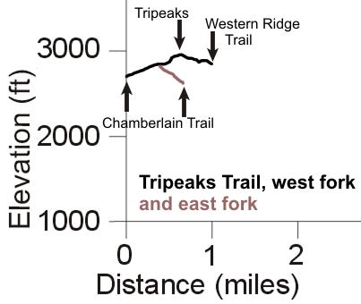
[27] Tripeaks Trail to
Boney Summit
 Description: Tripeaks
is a gigantic pile of huge rocks. There are a number of caves and crevasses
between them, many large enough to enter and explore. There are also spectacular
views into the valleys and canyons to the west. The trail leads from the
Chamberlain Trail, goes up and around Tripeaks, then down and up to Boney
Summit (AKA Peak 2701) and provides the easiest way to get to Boney Summit.
There are a number of geocaches in the area.
There are two forks of the Tripeaks Trail that meet the Chamberlain Trail.
Both forks are extremely rocky but not overly steep. The eastern fork
provides the shortest path from Circle X Ranch, but some may be overgrown,
depending on how recently volunteers have cut back the growth, a concern in
tick season. The southern fork is much wider. The trail climbs up to almost
the summit of Tripeaks about 400 yards past the junction of the southern
and eastern forks. There are places where it may be a little hard to follow
on the bare rock, but it travels around the peak counterclockwise, mostly against
a rock face, often steep down and a little loose. The trail eventually heads down
through the chaparral, emerging at a broad saddle point next to a huge boulder.
The trail climbs moderately (the elevation profile below may understate the
amount of climbing in this section) to meet the Western Ridge Trail shortly
before the Boney Summit.
Tripeaks is an area well worth visiting to see the caves and other rock formations.
The photo at right shows a narrow crack, several hundred feet long, that is
just wide enough to pass through without much difficulty.
To help you to find your way, you can download a GPS
track  of the Tripeaks trails.
Technical Rating HO
 T4
T4

|
Length (miles)
|
1.0 (to the Western Ridge Trail from Chamberlain
via the west fork)
0.3 (east fork) |
|
Climb (feet)
|
200 (to Tripeaks from Chamberlain via the west
fork)
280 (to the Western Ridge Trail from Chamberlain via the
west fork) |
|
Descent (feet)
|
0 (to Tripeaks from Chamberlain via the west
fork)
150 (to the Western Ridge Trail from Chamberlain via the
west fork) |
Trail Profile Back
to the Top
[28] Western Ridge Trail
to Boney Summit
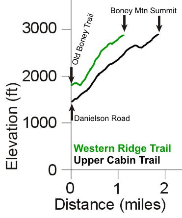
 Description: The Western
Ridge Trail is the most
spectacular way to get to the Boney Summit, but it provides some hiking
challenges. The trail starts about 1/2 mile from the north end of Old Boney
Trail, near the highest point where the trail turns right, the Western Ridge
Trail starts off to the left side and heads up the ridge. The trailhead is somewhat
hidden, next to a more prominent spur that heads down to the left, but ends
in a few dozen feet. But once on the trail the way is quite obvious. Even though
it is well-travelled, it is quite narrow through the chaparral so best to be
avoided during tick season. There are also many very steep sections, some that
require a small amount of rock climbing. There is one narrow section about
2/3 of the way up with a rock cliff on the right that has some poison oak in
the chaparral on the left, but it can be avoided if you keep a good watch for
it.
This is a tough hike but the incredible views and the satisfaction of
overcoming the challenges make it all worthwhile! Nevertheless, it is better
to take an easier route to the summit the first time. The Upper Cabin Trail
is a little easier but almost as steep and looser in places. The easiest route
to the summit is from Circle
X Ranch, via the Tripeaks Trail.
Once on the trail, it is quite easy to follow for most of it. However, there
are some places where it's easy to go astray, so you can download a GPS
track  to help you along.
Usually we take this trail up to the Boney Summit and then go back down on
the Upper Cabin Trail.
Technical Rating HO
 T5
T5

|
Length (miles)
|
1.1 |
|
Climb (feet)
|
1200 |
|
Descent (feet)
|
150 |
Trail Profile Back
to the Top
[29] Upper Cabin Trail to
Boney Summit
 Description: The Upper
Cabin Trail starts at the old cabin site and climbs to Boney Summit. It is a
challenging trail, steep and very rocky and rutted in many sections, and sometimes
loose as well. But the view from Boney Summit and points along the way make
the hike worthwhile. The trail is very well travelled and so overgrowth generally
isn't a problem. There is a photo
gallery dedicated in part to this trail
To help you to find your way, you can download a GPS
track  of the Upper Cabin Trail.
Technical Rating HO
 T5
T5

|
Length (miles)
|
1.8 |
|
Climb (feet)
|
1580 |
|
Descent (feet)
|
140 |
Trail Profile Back
to the Top
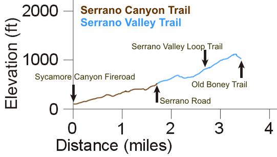
[30] Serrano Valley Trail
 Description: The Serrano
Valley Trail starts at the end of the Serrano Canyon Trail, in the south-west
corner of Serranon Valley. It winds north through the grassland of the valley
before heading into the chaparral and joining the Old Boney Trail. About 350
yards from the south end of the trail, in the grass meadow, is an old pump house
just off the trail.
The trail is well travelled and the tread is fairly smooth, but note that
the paths through the grass may move a little bit with each year of regrowth.
From almost everywhere in the Serrano Valley there are great views of the southern
flank of Boney Mountain and the huge rocks that have fallen from the top.
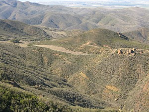
The photo shows the north section of the Serrano Valley Trail as seen from
above on the Chamberlain Trail.
Download the GPS track  of this
trail to help find your way through the grassland.
Technical Rating NB
 T2
T2

|
Length (miles)
|
1.7 |
|
Climb (feet)
|
570 |
|
Descent (feet)
|
160 |
Trail Profile Back
to the Top
[31] Serrano Valley
Loop Trail
 Description: This
trail provides an alternate route between Serrano Road and Serrano Valley Trail.
It passes along the northern section of the valley, through grassland and chapparal.
This trail used to be quite overgrown, but the SMMTC
trail crew cleared it out in the spring of 2009 (Thanks!!). There is an old rusty truck frame where the trail meets the Serrano Valley
Trail.
Download the GPS track  to help
you find your way.
Technical Rating NB
 T2
T2

|
Length (miles)
|
1.2 |
|
Climb (feet)
|
250 |
|
Descent (feet)
|
380 |
Trail Profile Back
to the Top

[32] Serrano Road
 Description: Serrano
Road starts at Cotharin Rd and you can drive about half-way down to the valley.
Park at the gate and hike down on the pavement, enjoying the views of the valley
and the southern flank of Serrano Valley. Except for a few places where the
road has succumbed to dirt, it is mostly paved until the old house. After that,
it's just a track that runs through the grass. It gets a lot of travel, even
so, the paths through the grass could move a little each year.
Download the GPS track  to help you find
your way.
Technical Rating NB
 T0.5
T0.5
 ,
T2
,
T2

|
Length (miles)
|
2.1 |
|
Climb (feet)
|
700 |
|
Descent (feet)
|
160 |
Trail Profile Back
to the Top

[33] Serrano Canyon Trail
 Description: This
trail starts in Sycamore Canyon just over a mile from the campground. It passes
through the canyon and ends in Serrano Valley at the south end of the Serrano
Valley Trail.
Most of the trail is quite close to the stream and there are a number of
crossings, none of them very difficult. Along the stream the trail is shaded
with high chaparral. Much of this trail has poison oak next to the trail and
encroaching on it in places, so try to avoid touching any of the plants! In
some places the trail climbs up above the stream where it's more open and you
have a better view, and a respite from watching for poison oak. This trail is
closed to horses.
Download the GPS track  to help you
find your way.
Technical Rating HO
 T2.5
T2.5

|
Length (miles)
|
1.75 |
|
Climb (feet)
|
730 |
|
Descent (feet)
|
230 |
Trail Profile Back
to the Top

This page last updated on February 7. 2021


 Description The Sycamore Canyon
Fire Road winds through the bottom of Sycamore Canyon from Newbury
Park to the Pacific Coast Highway. Much of the canyon floor
is covered with giant sycamore and oak trees. Because of the gentleness
of the slope when you start from the PCH end, it is very popolar
with people looking for an easy walk, with novice bikers, and
even parents pushing baby strollers. The only hazards are the stream
crossings of which there are about a half dozen near the south
end of the trail. Most of the year there is at least a little water
in the stream so people can expect to get their feet wet.

 Wood Canyon Fire Road
 Ranch Center Road, in front of Coyote Trail, with Wood Canyon in
the background
 [4]
Sin Nombre Single Track

 Description There are three
ways to climb up to the
 Description This rider (Steve)
thinks this is the best trail in Sycamore Canyon for mountain biking, although some
people poo-poo it because it is not a single track. In fact, that's
part of its attraction. The road starts in the north at the top
of Hell Hill and continues south to the Sycamore Canyon Fire
Road about a half mile from the campground and less than a mile
from the beach. A couple hundred yards or so past the top of Hell
Hill is the Wood Canyon
Vista Trail back down to the canyon. Continuing along, the road runs parallel to
the ridge that separates Sycamore Canyon from La Jolla Valley. At
some point the road crosses over the ridge so there are great views
into the valley and of the ocean below, ahead and to the right.
Further along there are views from the east side of the ridge down
into Sycamore Canyon and the ocean is ahead and to the left. The
descents here are really fun: long enough to pick up a little speed,
slightly rocky for a bit of a challenge, and wide enough to easily
go around any hikers or horses that are sharing the road (please
slow down to a crawl when passing horses - you don't want to startle
them so they throw their riders. Also,
a number of hikers and trail runners like to listen to music
players so don't count on them hearing you coming). Be careful at
the ends of the downhills because some of them end in very sharp
corners with a serious lack of horizontal ground beyond their
edges. When you get to a section where the road is composed of solid
white rock, you are approaching a left-hand switchback that signals
the final descent. From here the road is very firm but often has
some ruts crossing it that are good for high-speed bunny hops
(don't have clipless pedals yet? Get them!) and there are a
few more switchbacks before you get back to Sycamore Canyon Fire
Road. From here it's less than a mile to the beach. On the way back,
you can go up the Overlook trail to get some great exercise and
also you won't see any baby strollers.
 Struggling up Hell Hill
 Description: The Satwiwa
Native American Indian Cultural Center and Natural Area was established by
the National Park Service to display the heritage of the Chumash people who lived nearby.
There is a Native American guest host or Park Ranger on the weekends to answer
questions at the cultural center next to the demonstration village.


 Description: This
trail climbs to provide some great views of Satwiwa, Rancho Potrero, Hidden
Valley and the north flank of Boney Mountain. It starts with a moderately steep
climb from Danielson Road. The trail here is rocky and rutted but firm. The
trail levels out and becomes smoother as it goes through a meadow, then it splits.
The north fork is very steep and loose at first, then continues as a ridgeline
fireroad that has views on both sides into Hidden Valley. There are a few forks
towards the east end that wind down into private property.


 Description: The
Old Boney Trail must be the crown jewel of the Boney Mountain Wilderness Area.
The trail climbs, drops and winds around, providing tremendous and constantly
changing views of Boney Mountain, Sycamore Canyon, La Jolla Canyon, the Channel
Islands and more. There are several trails that connect it to Sycamore Canyon,
Serrano Valley and
 Description: This well-travelled
trail leads from the Upper Sycamore Trail, starting only about 400 feet from
Sycamore Canyon Fireroad. It climbs, and in places it is very steep, up to the
Old Boney Trail. It gets its name from the fossils in the rocks in the middle
of the trail about 2/3 of the way to the top. The elevation profile is shown above with that of
the Old Boney Trail.
 Description: The
Chamberlain Trail, part of the Backbone Trail, connects the Circle X Ranch
area to the Boney Mountain Wilderness. It starts at the convergence of the Mishe
Mokwa and Sandstone Peak trails in
 Description: Tripeaks
is a gigantic pile of huge rocks. There are a number of caves and crevasses
between them, many large enough to enter and explore. There are also spectacular
views into the valleys and canyons to the west. The trail leads from the
Chamberlain Trail, goes up and around Tripeaks, then down and up to Boney
Summit (AKA Peak 2701) and provides the easiest way to get to Boney Summit.
There are a number of geocaches in the area.
 Description: The Western
Ridge Trail is the
 Description: The Upper
Cabin Trail starts at the old cabin site and climbs to Boney Summit. It is a
challenging trail, steep and very rocky and rutted in many sections, and sometimes
loose as well. But the view from Boney Summit and points along the way make
the hike worthwhile. The trail is very well travelled and so overgrowth generally
isn't a problem. There is a
  Description: The Serrano
Valley Trail starts at the end of the Serrano Canyon Trail, in the south-west
corner of Serranon Valley. It winds north through the grassland of the valley
before heading into the chaparral and joining the Old Boney Trail. About 350
yards from the south end of the trail, in the grass meadow, is an old pump house
just off the trail.
 Description: This
trail provides an alternate route between Serrano Road and Serrano Valley Trail.
It passes along the northern section of the valley, through grassland and chapparal.
This trail used to be quite overgrown, but the
 Description: Serrano
Road starts at Cotharin Rd and you can drive about half-way down to the valley.
Park at the gate and hike down on the pavement, enjoying the views of the valley
and the southern flank of Serrano Valley. Except for a few places where the
road has succumbed to dirt, it is mostly paved until the old house. After that,
it's just a track that runs through the grass. It gets a lot of travel, even
so, the paths through the grass could move a little each year.
 Description: This
trail starts in Sycamore Canyon just over a mile from the campground. It passes
through the canyon and ends in Serrano Valley at the south end of the Serrano
Valley Trail.