|
Trails of Las Padres National Forest |
|
|
Topatopa Bluff to Santa Paula Peak, including Santa Paula Canyon |
|
|
|
This map includes some of the south-east section of the Los Padres National Forest, the Sespe Wilderness Area and the western edge of the Sespe Condor Sanctuary. There are a number of hiking trails that match this rugged area in character. On many of them, you can hike all day and are likely to see few, if any, other people. You will, however, see many stunning views!
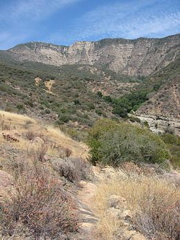
The Santa Paula Canyon is best known for its clear water and deep pools, great for jumping into on a hot day, that most people refer to as the "punch bowls." However, the Forest Service map shows a distinct structure labeled "The Punch Bowl" that is some distance east of the river. Regardless, the pools, waterfalls and chasms of the canyon are a popular destination, both for their intrinsic beauty and because it's fun to play in the water! The stream runs year-round with cool water that is very refreshing on a hot summer day.
This area includes the Topatopa Bluff, which, with distinctive horizontal banding on its massive near-vertical face, is visible for miles from the south-west. And the view from the top is equally impressive! During the summer and fall, you can drive to the base of the Topatopa Bluff Trail along Nordhoff Ridge Road if you have a 4-wheel drive and a permit from the Ojai Ranger Station. It's a long drive from Rose Valley but it will save you hours of hiking up Sisar Canyon and about 3000' of climbing.
The US Forest Service has an online map that shows the trails and undeveloped campsites in the area.


a. The parking area and trailhead for the Santa Paula Canyon Trail is almost directly across Highway
150 from Thomas Aquinas College. Take care not to leave any valuables behind because
many cars have been broken into here. Map
and directions.
b. At the north end of Sisar Road in Ojai. There is a
gate here that blocks vehicles from driving up Sisar Canyon. Map
and directions.
c. At the east end of Nordhoff Ridge Road (5N08). You
need a permit from the Ojai
Ranger Station to drive on Nordhoff Ridge Road. Only 4-wheel drive vehicles
are permitted. Nordhoff Ridge Road is closed for three days after a heavy rain,
and most of the winter and spring as well.
q. Locked Gate
r. Santa Paula Peak
s. Topatopa Peak
t. Hines Peak
u.
Topatopa Bluff
v. Upper pool
w. Barrier rock
x. Chasm
y. Lower pool
z. Thomas
Aquinas College
[1]
East Fork Trail (AKA Santa Paula Canyon Trail, "Punch Bowls"
Trail)
 Description This
is a very popular trail for families and young adults to get to the natural pools
in the Santa Paula Creek for swimming. Most people refer to these pools as the
Punch Bowls, for which the area is named. Even without the attraction of the
pools and cliffs for jumping into the deeper water, this is a very pretty
area in it's own right. Some people consider it to be one of the prettiest areas
in Ventura County, and it's also a fairly easy trail to hike because it isn't
very steep, although there are a few short sections where climbing over big
rocks or scrambling up loose dirt is required.
Description This
is a very popular trail for families and young adults to get to the natural pools
in the Santa Paula Creek for swimming. Most people refer to these pools as the
Punch Bowls, for which the area is named. Even without the attraction of the
pools and cliffs for jumping into the deeper water, this is a very pretty
area in it's own right. Some people consider it to be one of the prettiest areas
in Ventura County, and it's also a fairly easy trail to hike because it isn't
very steep, although there are a few short sections where climbing over big
rocks or scrambling up loose dirt is required.
The first 1.3 miles, starting at the entrance to Thomas Aquinas College, is on pavement. After that, the trail is a mixture of an old dirt road and the gravel and rocks of the streambed with some boulder hopping thrown in for good measure. Several years ago, storms washed away much of the old road that ran along the creek so now there are two trails in some parts - the original fragments of the road and the new path, mostly along the gravel of the streambed. Most likely future storms will change the course of part of the trail again.
It is possible to hike up the streambed all the way to the lower pool, and many people do. However, it's much easier to find the old trail on the south side of the stream about 2.8 miles from Hwy 150. This trail is well-traveled and has a broad and firm tread. It starts with a switchback so from the stream it looks like it goes the wrong way but it climbs and turns upstream shortly.
From the lower pool, the trail climbs a short steep and rocky section. At the top, the trail forks. To the right (heading uphill) is a short trail that starts of well but peters out after a few hundred yards. The trail to the left continues to the top of the chasm where there are some places to jump off the cliff into the deep pool below.
Unfortunately, the East Fork Trail has been marred by graffiti and litter in recent years. Despite that, it's still worth hiking for the pool, cliffs and other rock formations that start at the lower pool. The graffiti continues to the upper pool. This trail also gives access to the Last Chance Trail.
Download the GPS track ![]() to help you
find your way. This track stops at the Barrier rock. The GPS is mostly useless
in the narrow canyon further upstream.
to help you
find your way. This track stops at the Barrier rock. The GPS is mostly useless
in the narrow canyon further upstream.
|
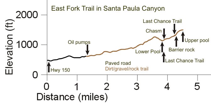
Length (miles) |
4.3 from parking to the Barrier rock |
|
Climb (feet) |
1300 |
|
Descent (feet) |
450 |
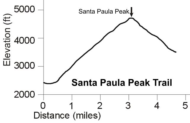
Trail Profile Back to the Top
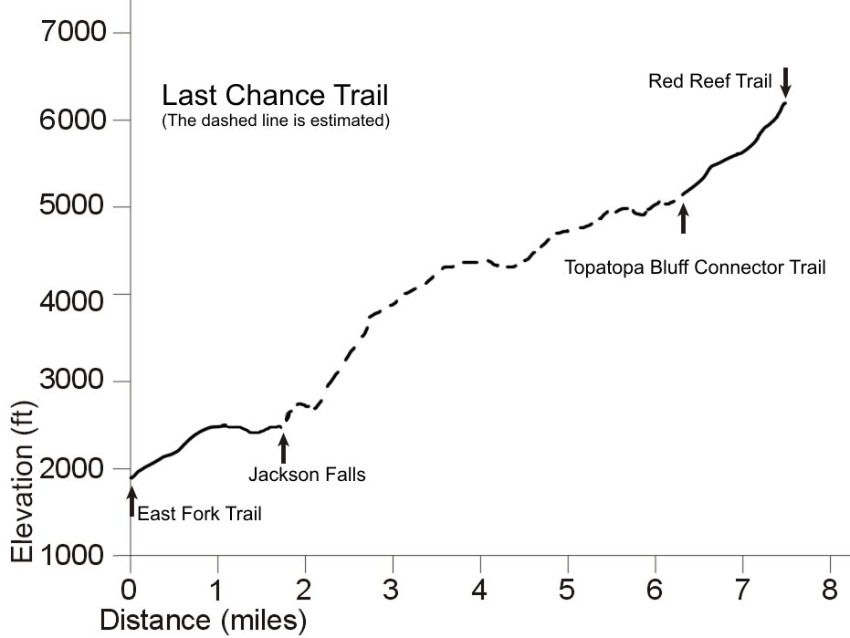
Description The Last Chance Trail extends to the east of the East Fork Trail from just above the lower pool and heads north from the East Fork Trail not far before the Barrier rock. It is named for the Last Chance campsite located about four miles up. The north section is completely within the Sespe Wilderness Area and ends at the Red Reef Trail. So far I have hiked only 1.7 miles north of the East Fork Trail to Jackson Falls and 1.2 miles south of the Red Reef Trail so I can only describe those parts of it.
At the bottom, the trail seems quite well traveled. It starts by climbing up through a mostly grassy, shadeless area but soon comes to trees and tall chaparral where there is lots of shade. It climbs up above Santa Paula Canyon and in places it runs close to the edge where you can get a good view into the canyon. The profile below shows the steepness of the climb up above the canyon. From Jackson Falls, the trail is supposed to continue up the streambed for several hundred yards before climbing out steeply.
At the top, the trail is still well travelled but has some small plants starting to grow in the middle of the trail. It climbs with a moderate steepness through a narrow canyon with a very firm tread. The last 0.6 miles becomes steeper and narrower. The trail here has many short switchbacks, mostly on skree and decomposed granite, but still quite firm underfoot, as it climbs out of the canyon up to the Red Reef Trail.
Update April 2013: I've tried to find my way upstream of Jackson Falls a couple of times, but haven't been able to find anything that looks like a trail around the falls. I received a report from the past two weeks that the trail above the falls is almost obliterated because of overgrowth and erosion. Unfortunately it appears that the middle portion of this trail, at the least, will be reclaimed by nature soon. Thanks for the report, Jake!
Download the GPS track ![]() to help you
find your way. This track only covers a bit over two miles of the trail.
to help you
find your way. This track only covers a bit over two miles of the trail.
Technical Rating T2.5
![]()
|
Length (miles) |
Several |
|
Climb (feet) |
|
|
Descent (feet) |
Trail Profile Back to the Top
Description This section of the Red Reef Trail extends from the east end of Nordhoff Ridge Road north-east to the Sespe River Trail. I have hiked to the saddle north-west of Hines Peak from Nordhoff Ridge Road. This section of the trail is an old roadbed, broad and mostly smooth and firm. Much of it travels along a ridgeline where you have an excellent view into Rose Valley, the Sespe Creek and the mountains north of it.
Download my GPS track ![]() to help you find your way. The track of the whole trail is available from
Redtrails.com
to help you find your way. The track of the whole trail is available from
Redtrails.com
Technical Rating T2
![]()
|
Length (miles) |
10.5 |
|
Climb (feet) |
|
|
Descent (feet) |
Trail Profile Back to the Top

[4a, b]
Topatopa Bluff Trail and Topatopa Bluff Road
The Topatopa bluff as seen
from below on Sisar Canyon Road
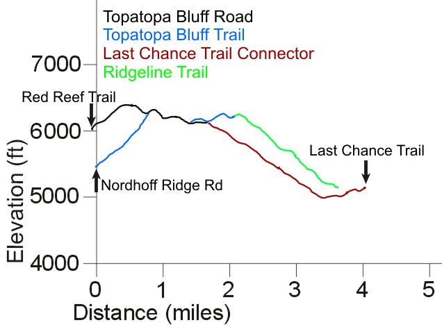
Description The Topatopa Bluff Trail climbs steeply up the north face of the bluff. It starts at Nordhoff Ridge Road, about 300 feet from the parking area at the east end. After climbing 900 feet in 0.8 miles, it follows the ridgeline south-east, connecting to Topotopo Bluff Road, diverging from it and then crossing it just after the Last Chance Connector Trail. It continues south-west along the ridge for another 0.4 miles. At this point it turns east and suffers the effects of lack of use. This ridgeline trail is shown as a dashed line on the map above. It's mostly easy to follow, but it gets lost in the overgrowth in a few spots. From the satellite photos, it looks lilke it goes all the way to Santa Paula Canyon.
As you can imagine, there are tremendous views in every direction from the Topatopa Bluff Trail, especially on the top!
The Topatopa Bluff Road comes up from the Red Reef Trail about a mile north-east of the end of Nordhoff Ridge Rd. It's not as steep as the trail, but it's longer and climbs a little higher. As it's no longer maintained, it will slowly narrow as rocks fall on it from the steep slope above.
Download the GPS track ![]() to help you
find your way.
to help you
find your way.
Technical Rating T2.5
![]()
|
Length (miles) |
0.8 to the top; 1.6 to the Last Chance Trail Connector; 2.1 to the ridge trail |
|
Climb (feet) |
900 to the top; 1000 to the Last Chance Trail Connector; 1200 to the ridge trail |
|
Descent (feet) |
zero to the top; 400 to the Last Chance Trail Connector; 500 to the ridge trail |
Trail Profile Back to the Top
[5]
Topatopa Bluff - Last Chance Connector Trail (aka Poodle-dog Bush
Trail)
View of Hines Peak (left)
from the Topatopa Bluff - Last Chance Connector Trail
Description This trail heads east from the top of Topatopa Bluff to connect with the Last Chance Trail over 2.3 miles. As of August 2009, it starts off very well at the top and is very easy to follow for about the first mile. When the trail starts switchbacking down the hill, it becomes more and more overgrown as you continue north-east. There are small strips of flagging tape tied to the trees to help you find your way, but even with that, it's hard to find the path in some places, especially close to the two creek crossing. The GPS track below will be a great help for finding your way.
Much of the overgrowth is due to poodle-dog bushes (hence the trail name), a fire follower. Some people are very sensitive to this bush and contact can result in an itchy or sore rash, so be careful along this path! This article describes the poodle-dog bush and includes photos.
Download the GPS track ![]() to help you
find your way.
to help you
find your way.
Technical Rating T2.5
![]()
|
Length (miles) |
2.3 |
|
Climb (feet) |
300 |
|
Descent (feet) |
1300 |
Description I have not yet been on this trail so I can't provide any description. I downloaded the GPS track from Redtrails.com and derived the elevation profile from that.
Trail Profile Back to the Top
This page last updated April 1, 2013
|
|
Thanks for looking at Steve's guide to trails in Ventura County, the Santa Monica Mountains National Recreation Area (SMMNRA) and other locations. |
|