|
Trails of
Valley View Preserve in Ojai north to the west
end of Nordhoff Ridge
|
|
|
|
|

Looking
east from the Fox Canyon Trail at Foothill Trail (left, in the valley) and
Luci's (right, on the ridge). At the extreme right, near the bottom,
is Shelf Road.
|
Overview
The Valley View Preserve is a very pretty area with trails that provide easy
access to great views of the Ojai Valley, and also to more secluded area where
there is little indication of the nearby civilization: Fox Canyon and Luci's
Trails, and they are not far from parking. These trails lead north into
the hills and mountains; there are also three main east-west trails to connect
them and others.
Behind, and above, the Valley View Preserve is Nordhoff Ridge, a steep mountain
that climbs up 3500 feet above the valley floor, providing an amazing backdrop.
The Nordhoff Ridge Road along the crest of the ridge can be accessed by two
singletracks, the Gridley and Pratt Trails. There is an old fire lookout tower
at the peak of the mountain that provides incredible views in all directions,
into Ojai Valley to the south and Rose Valley to the north, as well as along
Nordhoff Ridge itself and the rugged moutains of the Los
Padres National Forest that surround it all. See if you can follow the route
of Highway 33 between Ojai and Rose Valleys from the lookout tower!
Further east along Nordhoff Ridge are other trails that lead down to the
valley. They're described on the Nordhoff
Ridge page.
Like all of Ojai, this area can get really hot in the summer. Being against
Nordhoff Ridge, it gets more than the average amount of rainfall in the winter.
Keep yourself safe and check the weather before heading out to the trails. Excess
heat can be deadly!
Ojai is a real hotbed of geocaching
with a number of real enthusiasts living nearby. As such, all of the trails
have geocaches hidden along them at least every quarter mile. If you like being
on the trails and geocaching, or are interested in learning more about the sport,
this is a great place to be!
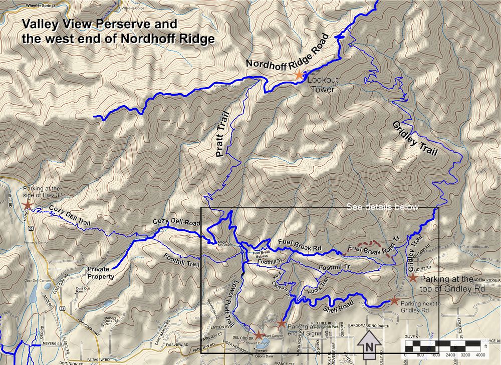
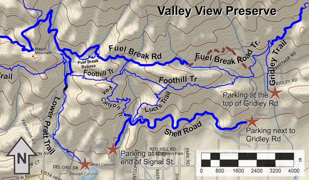
Map of the Valley View Preserve trails
Official Websites
Trailheads
- Lower Pratt Trailhead, just west of the north end of N. Signal Street.
Map
and Directions.
- There is room for a few cars at the side of the road
at the north end of N. Signal Street for Shelf Road.
Map
and Directions.
- The Gridley
Trailhead at the north end of Gridley Road. Map
and Directions.
- There is room for a few cars just down the street at
the east end of Shelf Road. Map
and Directions.
Trails
Trails are listed here in alphabetic order. Download the GPS tracks  to help you find your way. This GPX file contains tracks
for all the trails in this area.
 Cozy Dell Trail
(23W26) T4
 ,
T2.5

Description This is a very pretty and justifiably popular
trail. It starts at the west end at Hwy 33 with a moderately steep, switchbacked
climb for about 0.8 miles. The trail here has lots of shade from oak trees.
The tread is firm but rocky in spots with many rock steps. This section
of the trail is rated T4
 .
From the top of the climb, the trail becomes gently rolling, smoother and
broader in places. It is about 50% shaded by trees and tall chaparral and there
are great views in every direction. This part of the trail, to where it ends
in the east at Cozy Dell Road, is rated T2.5
 .
.
Technical Rating T4
 ,
T2.5

|
Length (miles)
|
1.9 |
|
Climb (feet)
|
900 (Hwy 33 to Cozy Dell Road) |
|
Descent (feet)
|
400 |
Trail Profile Back
to the Top

 Cozy Dell
Road (5N34; AKA Cozy Ojai Rd.) T1

Description Cozy Dell Road is a very pretty trail
that continues westward from the west end of Fuel Break Road. (From the official
maps, it's unclear where Fuel Break ends and Cozy Dell starts, but we
assume that occurs at the saddle where Upper Pratt heads up towards Nordhoff
Ridge.) Heading west and downhill, Cozy Dell Rd passes the west end of Foothill Trail then the east end of Cozy
Dell Trail, contining another half mile then stops at a dead end where
it runs into private property. The road is moderately steep and heavily shaded
by oak trees. It is very pretty and highly recommended.
Technical Rating T1

|
Length (miles)
|
1.1 from Pratt to Cozy Dell Trail, 1.7 total |
|
Climb (feet)
|
100 from Pratt to Cozy Dell Trail, 100 total |
|
Descent (feet)
|
800 from Pratt to Cozy Dell Trail, 1000 total |
Trail Profile Back
to the Top
 Foothill Trail
T2
 ,
T4
,
T4
 & T5
& T5

Description The Foothill Trail is a pretty singletrack
that starts at the west end at Cozy Dell Road, a hundred feet or so above
where the Cozy Dell Trail ends. It crosses the fireroad section of Lower Pratt
and then continues east until it runs into Fuel Break Road Trail.
There are some outstanding views along this trail, especially
east of Lower Pratt.
Mountain bikers and equestrians take note: Overall, the trail is firm and smooth with a decent amount of
shade T2
 ,
but 250 yeards of the section immediately west of Lower Pratt is steep and very
uneven, T5
 .
There is also a very steep section about 750 yards west of Lower Pratt. Similarly,
the first 400 yards east of Lower Pratt is steepish, uneven and has sharp turns,
T4
 .
But mostly it's not so difficult to ride.
Technical Rating T2
 ,
T4
,
T4
 & T5
& T5

|
Length (miles)
|
3.22 |
|
Climb (feet)
|
|
|
Descent (feet)
|
|
Trail Profile Back
to the Top
Fox Canyon
Trail T5

Description The Fox Canyon Trail climbs from Shelf Road
to Foothill Trail. It is pretty steep and has many rocky steps, especially at
switchbacks, resulting in a T5 rating for this trail. It is not recommended
for any but the most experieced (and daring) mountain bikers!
Because of the steepness, you gain elevation quickly as you
climb, and are treated to better and better views of Ojai valley, and the
smaller but much prettier valley that Foothill Trail runs through.
A good hike for those who want great views and don't mind steep
trails is to make a loop out of Fox Canyon and Luci's
Trail.
Technical Rating T5

|
Length (miles)
|
1.0 |
|
Climb (feet)
|
620 |
|
Descent (feet)
|
20 |
Trail Profile Back
to the Top

 Fuel
Break Bypass Trail T2

Description This short singletrack was constructed during
the great covid-19 pandemic of 2020 - 2023. It's a beautiful trail that bypasses
a particularly rugged section of Fuel Break Road, dropping through a wooded
area to cross the seasonal Stewart Canyon Creek before rejoining Fuel Break
Road. This route is highly recommended!
Technical Rating T2

|
Length (miles)
|
0.3 (500 yards) |
|
Climb (feet)
|
20 (east to west) |
|
Descent (feet)
|
140 |
Back
to the Top
Fuel Break Rd
and Fuel Break Road Trail
(AKA Hermitage Rd, Cozy Ojai Rd.) T1
 and T2.5

 Description Fuel
Break Road runs from Upper Pratt Trail in the west (where is becomes Cozy Dell
Road) to Gridley Trail in the east, with connections to Foothill Trail. Like
Footlhill Trail, it has great views of the surrounding mountains, but you can't
see into the Ojai Valley, so it feels much more remote.
This is a good route to connect the bottom of Gridley
with the bottom of Pratt Trail. Towards the west end is a singletrack section
(Fuel Break Road Trail)
that avoids private property and connects with a dirt road that leads to the
bottom of Gridley at the start of the avacado orchard, 0.4 miles from the trailhead.
It's not very long, only 2.3 miles, but it's surprisingly
hilly, especially after climbing Gridley and descending Pratt! For an easy connection
between the bottom of Pratt and Gridley, consider Shelf
Road.
Technical Rating Fireroad section T1
 ;
Singletrack, T2.5

|
Length (miles)
|
3.1 |
|
Climb (feet)
|
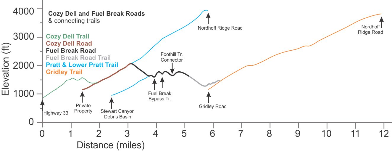
Depends on where you get on and off it.
Refer to the elevation profile below. |
|
Descent (feet)
|
|
Trail Profile Back
to the Top

Fuel Break - Foothill Connector Trail
Description This short trail, less than 300 yards long,
connects Fuel Break Road to Foothill Trail. It's shown on the map
above, but not labelled. It's between the top of Fox Canyon Trail and Luci's,
about 200 yards east of Fox Canyon Trail. It gets a little higher technical
rating because it's somewhat steep at the north end where it joins Fuel Break
Road.
Technical Rating T2.5

|
Length (miles)
|
0.16 |
|
Climb (feet)
|
|
|
Descent (feet)
|
|
Back
to the Top
Gridley Trail (22W05) and
Nordhoff Ridge Rd (5N08) to Nordhoff Peak T3
 , T4.5
  .
.
|

Climbing
Gridley just past the horse trough
|
Description This is a beautiful singletrack that affords some
spectacular views along the way. Mountain bikers will find some technical challenges
in the form of rocks and tight switchbacks. For an added challenge, mtn
bikers
can climb the very steep Nordhoff Ridge Rd to the old fire lookout tower at
Nordhoff Peak before coasting all the way back down to the start.
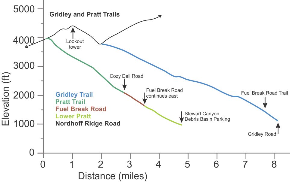
The trail begins with a somewhat rocky but firm climb up a short connector trail to get to a dirt road that skirts
an avocado orchard. After the avocado trees are passed, the old road becomes
more rutted, rocky and narrow, but is still firm and not very steep. About a third of the way to the top is the horse trough, a good spot
for a short break. After that the trail is noticibly
more technical, even though it's not really any steeper for the most part. However,
it's narrower, rutted and has rocks protruding from the firm dirt of the trailbed
with a few rocky switchbacks. Finally, it crosses a steep slope with a
lot of exposure. For mountain bikers, this part of the trail is best for people with
good technical riding skills, especially for the return trip. At the top is a very
steep fireroad about a mile long that leads to an old lookout tower
at Nordhoff Peak.
On a clear day, the views from the top make the extra climb up worth the effort.
The trip back down can be really fun if you love narrow and rocky downhill!
An alternative is to make a loop by continuing
west and down on Nordhoff Ridge Road about a mile and then descending the
Pratt Trail on the left. Keep in mind that Pratt is a little steeper overall
than Gridley. You can connect back to Gridley by way of Fuel Break Road, but
that can be a little hilly after a long ride (especially if it's a hot day).
An easier way back is to go all the way down Pratt, ride Signal Street about
a block to the east end of Shelf Road, take Shelf Road to the east end where
it's another block to the trailhead at the bottom of Gridley.

View of the valley from two-thirds of the way up Gridley Trail
If you think this trail is steep, see
how it compares to other steep trails.
Technical Rating From the bottom to the horse trough, T3
 .
From there to the top, T4.5
  .
.
|
Length (miles)
|
6.1 to Nordhoff Ridge, 7.3 to Nordhoff Peak |
|
Climb (feet)
|
2600 to Nordhoff Ridge, 3300 to Nordhoff Peak
(estimated) |
|
Descent (feet)
|
100 (estimated) |
Trail Profile Back
to the Top
Luci's Trail
T4

Description This trail climbs from Shelf Road to
Foothill Trail. There are two connections to Shelf Road - most people who start
from Signal Street take the one that is further west. Overall the trail is
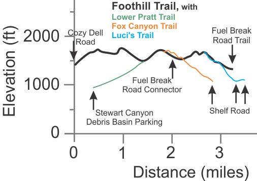
pretty steep; you can see from the profile below that is is steeper than
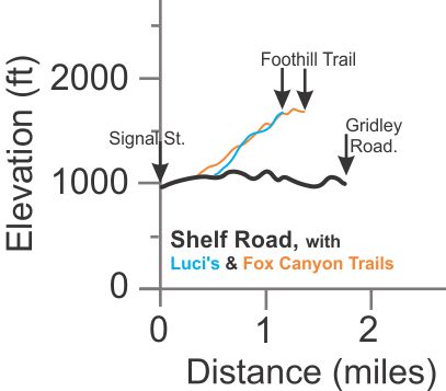
Fox Canyon Trail. Of particular concern is the rock stairway at the top about
500' long. It is not recommended for any but the most experieced (and daring)
mountain bikers!
Because of the steepness, you gain elevation quickly as you
climb, and are treated to better and better views of Ojai valley, and the
smaller but much prettier valley that Foothill Trail runs through just east
of Luci's.
A good hike for those who want great views and don't mind steep
trails is to make a loop out of Fox Canyon and
Luci's Trail.
Technical Rating T4

|
Length (miles)
|
0.8 |
|
Climb (feet)
|
600 |
|
Descent (feet)
|
20 |
Trail Profile Back
to the Top

Nordhoff Ridge Road (5N08) T1

Description This broad fireroad travels along Nordhoff Ridge, giving
commanding views into the Ojai Valley to the south and Rose Valley and the Sespe
Wilderness Area to the north. Several trails lead up from the valleys below
and end at this road. Nordhoff Ridge Road ends at the Sespe Wilderness Area
in the east, below Topatopa Bluff. It provides convenient access to a number
of trails, but there is no shade for long stretches and it can get very hot
in the summer, so plan accordingly.
This road is open to 4-wheel drive vehicles in the summer and fall until
the rain or snow in the winter washes it out. A permit is required to drive
on this road. They are available from the Ojai
Valley Ranger Station. Access to the road is via the Nordhoff Ridge Access
Road (5N42) that comes up from Rose Valley.
There is an old fire lookout tower at the top of Nordhoff Peak, only a mile
from the top of Gridley, and a little less from the top of Pratt. The tower,
with its commanding views in all directions, is a popular destination for those
who climb either Pratt or Gridley.
Technical Rating T1

|
Length (miles)
|
14.5 |
|
Climb (feet)
|
Depends on where you get on and off it.
Refer to the elevation profile below. |
|
Descent (feet)
|
|
Trail Profile Back
to the Top

Pratt Trail
(23W09) from Nordhoff Peak T4.5

|

View
of the Pratt Trail from Nordhoff Ridge, with the Ojai Valley in
the background.
|
Description Pratt Trail is one of the two main trails from Ojai to
Nordhoff Peak, the other being Gridley. The character of the trails is quite
different. Pratt is a little steeper (1.5 miles shorter with slightly more elevation
change) but has a less rocky tread, but some sections of decomposed granite
that is a little loose.
The Pratt Trailhead is at the Stewart Canyon Debris Basin. The trail starts
off quite rocky, winding between the houses for almost a mile. It follows the
pavement up briefly before turning onto a fireroad for 600 yards, and then joins Fuel
Break Road for 2/3 miles. Then it
turns north as a singletrack, climbing 2.75 miles to Nordhoff Ridge.
From there it is another 0.9 miles to Nordhoff Peak.
For mountain bikers, the Pratt is a fun alternative to Gridley for returning
to the valley. The last mile is particularly fun, with many small steps and
drops through the rocks.
Technical Rating From Nordhoff Peak to Cozy Dell Rd, T4.5
 .
Dirt road section, T1.5
 .
Lower Pratt, T3.5
 .
.
|
Length (miles)
|
4.7 (Trailhead to Nordhoff Ridge Rd) |
|
Climb (feet)
|
3100 |
|
Descent (feet)
|
100 |
Trail Profile Back
to the Top

Shelf Rd
(AKA Valley View Rd) T1

Description The west end of this dirt road starts at the top of Signal
Street and ends at Gridley Road in the east. There is parking for a few cars
at each end. This is the major entrance to the trails of the Valley View Preserve
- Fox Canyon and Luci's Trails less than a half mile from the west end. The road very closely follows the contour of the
hillside to give gradual, rolling hills. For connecting the bottom
of Pratt with the bottom of Gridley, it is much easier than Fuel Break Rd because
there is much less climbing.
Technical Rating T1

|
Length (miles)
|
1.7 |
|
Climb (feet)
|
approx 300 |
|
Descent (feet)
|
approx 300 |
Trail Profile Back
to the Top
This page last updated on August 21, 2023


 Fuel
Break Bypass Trail


