![]() Printable map (1.9 MB)
Printable map (1.9 MB)
![]() Printable map
including nearby trails (4.2 MB)
Printable map
including nearby trails (4.2 MB)
|
Trails of |
||
|
Newbury Park within the Potrero Ridge Open Space |
||
|
|
|
Potrero Ridge extends roughly from Helga Court (off of Lynn Rd) east to Rancho Dos Vientos at the west end of the Dos Vientos neighborhood. The ridge has major breaks through which Wendy Rd, Reino Rd, Via Las Brisas and Rancho Dos Vientos pass. The Potrero Ridge Open Space encompasses the eastern part of Potrero Ridge in Newbury Park. There are many trails here, most of them not very long and some of them hilly. Nevertheless, they provide great opportunities for quick neighborhood hikes, and when connected properly, they provide a route from Los Robles Trail West to the trails of Dos Vientos, enabling a loop route through Rancho Sierra Vista/Satwiwa with a few short sections on pavement.
|
|

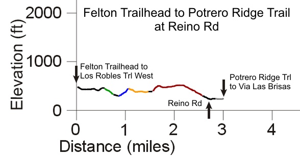
The dotted pink line shows a suggested route to connect the Los Robles Trail West to the Potrero Ridge Trail that leads to Dos Vientos. The overview map below shows how this can be connected to Rancho Sierra Vista/Satwiwa to travel a loop. The elevation profile of this route is shown in the Potrero Ridge Trail section.


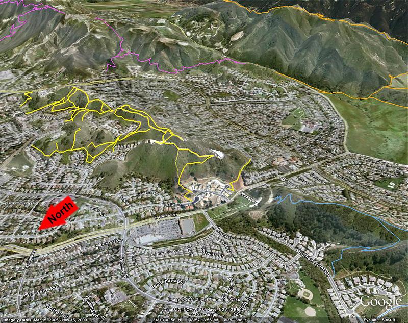
Looking south-west
at Potrero Ridge, where the trails are shown in yellow. The magenta trail is
Los Robles Trail West; the cyan trail is the section of the Potrero Ridge Trail
that leads west into Dos Vientos; the orange trails are in Rancho Sierra Vista/Satwiwa. This view is from Google
Earth.
a. Wendy Drive (west side), between Peppermint and Felton. There is
a paved parking lot here. Map and directions.
b. Wendy Drive (east side).
There is no parking here.
c. Bear Creek Drive. There is parking at
the side of the street. Map and directions.
d. Peppermint Street. There is
parking at the side of the street. Map and directions.
e. Highview Street.
There is parking at the side of the street. Map and directions.
f. Helga Court, off of Lynn Rd.
There is parking at the side of the street. Map
and directions.
g. Felton Street. There is parking at the side of the
street. Map and directions.
h. Holloway Street. There is parking at the side
of the street. Map and directions.
i. Astera Court. There is parking at the
side of the street. Map and directions.
j. Walter Avenue, from Kimber Drive.
There is parking at the side of the street. Map and directions.
k. Woodland
Oaks Place. There is parking at the side of the street. Map and directions.
l.
Gravel parking lot. Access is from the west side of Reino Road, between Dunaway
Dr and Paseo De Leon. Map
and directions.
m. Potrero Rd (north side). There is a large gravel parking
lot here. Map
and directions.
n. Potrero Road at Wendy Drive. There is a large gravel
parking area here. Map and directions.
o. Main paved parking area for Rancho
Sierra Vista/Satwiwa, off of Lynn Road. Map and directions.
p. Via Las Brisas.
There is no parking here.
q. Mountain Creek Drive. There is parking at the
side of the road. Map
and directions.
[1] Potrero Ridge Trail (AKA Wendy Water Tank Trail)
Description As described in the overview, Potrero Ridge covers a lot of territory in Newbury Park and Dos Vientos. The Potrero Ridge Trail proper runs from Wendy Rd east to Via Las Brisas and is broken by Reino Rd. The prominent trail between Wendy and Reino is a dirt road that climbs gently from Wendy Drive for about a half mile to a water tank, then turns downhill, ending at a locked gate. At this point, a new singletrack trail (built by volunteers during the COSCA Spring Trailwork Day in March, 2011) follows a gentle slope almost to the neighborhood below. The last hundred feet or so are outside of the open space and are considerably steeper. A singletrack trail leads directly up the ridgeline, parallel to the dirt road and slightly to the south. Other trails provide access to the North Potrero Ridge Open Space from the dirt road. The section of the Potrero Ridge Trail between Reino and Via Las Brisas is described elsewhere.

Color Key to the profile
Black - Paved road (from left to right, Felton St, Lynn Rd, Helga
Ct; Silas Lane; Wendy Dr; Woodland Oak Pl, Reino Rd)
Green
- Helga Trail
Blue - Silas Lane Trail
Orange
- East Potrero Ridge Open Space Trails
Red
- Potrero Ridge Trail (Wendy Drive to Reino Rd)
Grey
- Driveway from Reino Rd to Potrero Ridge Trail that leads to Dos Vientos
Download the GPS track ![]() of the Potrero Ridge Trail in Newbury Park to help you find your way.
of the Potrero Ridge Trail in Newbury Park to help you find your way.
Download the GPS track ![]() of the route from Felton to Reino Rd to help you find your way.
of the route from Felton to Reino Rd to help you find your way.
Technical Rating T1
![]() (fireroad); T2.5
(fireroad); T2.5
![]() (singletrack
ridgeline trail)
(singletrack
ridgeline trail)
[2] North Potrero Ridge Open Space Trails
Description For the most part, these trails follow the edge of the meadow open spaces on the west side of Wendy Rd. They provide a good venue, for example, for a brisk evening stroll away from traffic. The trail that leads to the middle of the Potrero Ridge Trail dirt road is moderately steep and rutted with loose surface rocks.
Download the GPS track ![]() to help you find your way.
to help you find your way.
Technical Rating T2.5
![]()
[3] East Potrero Ridge Open Space Trails
Description This area has a combination of trails that follow along the edge of the meadow areas on the east side of Wendy Drive, and steeper fall-line trails that run straight up the hills through the chaparral. Like the North Potrero RIdge Open Space Trails, this is a good area for neighborhood folks to get in a quick walk.
Download the GPS track ![]() to help you find your way.
to help you find your way.
Technical Rating T2.5
![]()
Description This short and broad trail (really a grassy lane) leads from Silas Lane to the East Potrero Ridge Open Space Trails.
Download the GPS track ![]() to help you find your way.
to help you find your way.
Technical Rating T1.5
![]()
Description This switchbacking trail, built to multiuse standards, leads from the end of Helga Court down to Silas Lane. It provides the connection between the Los Robles Trail from Felton Street and the Potrero Ridge Trails, but it is not well known.
Download the GPS track ![]() to help you find your way.
to help you find your way.
Technical Rating T2
![]()
Description This short and nearly flat trail leads from the west end of Holloway Street to the south end of Astera Ct. There is a narrow opening in the fence at Holloway that provides access. If you're riding, you may have to lift your bike over the fence. Horses won't fit through.
Download the GPS track ![]() to help you find your way.
to help you find your way.
Technical Rating T2
![]()
This page was last updated April 15, 2011
|
|
Thanks for looking at Steve's guide to trails in Ventura County, the Santa Monica Mountains National Recreation Area (SMMNRA) and other locations. |
|