Trails of
Leo Carrillo State
Park and Arroyo Sequit
including Nicholas Flat
- Photos
- Videos
- Area Weather
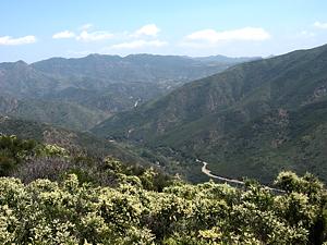
Looking
north over Nicholas Flat with Yerba Buena Rd and Ezt Meloy Mtwy
in the distance
|
Trails of Leo Carrillo State
Park and Arroyo Sequit |
||
|
||
|
||
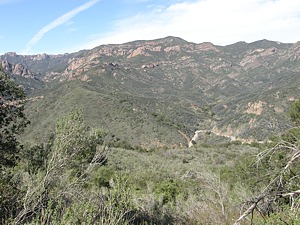
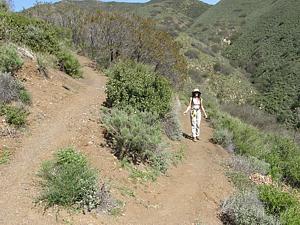
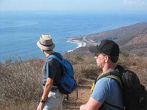
This area is dominated by two features: the Malibu coastline and the south flank of Boney Mountain including Sandstone Peak and Yellow Hill. From most trails, you'll have a view north to the mountains or south to the coast. In some locations you'll see both together.
When using most of the trails in this area, you'll pass few, if any other people along your route. The seeming remoteness belies their proximity to homes all all sizes, from trailers to humongous hilltop mansions. Even so, the trails are generally in good shape and well maintained.
Some of the trails in this area will become part of the planned Coastal Slope Trail.
The Charmlee Natural Area is included on the map here to show its proximity to other trails, but it has a web page of its own to properly show all its trails.


This view is from Google
Earth. Hover over the trails to find their locations.
a. Yellow Hill Fireroad Trailhead, on Mulholland Highway, 0.1 mile
north of the PCH. There is only room for a couple of cars here. Map
and Directions
b. Leo Carrillo State Park on the PCH. There is
lots of parking here, for a fee. Map
and Directions
c. Malibu Springs Trailhead on Mulholland Hwy.
There is only room for a couple of cars here. Map
and Directions
d. Nicholas Flat Trailhead at the west end of Decker
School Road. Be careful not to confuse this street with the nearby Decker School
Lane. There is room for several cars here. Map
and Directions
e. Parking for the Arroyo Sequit area, just off
of Mulholland Hwy, on Mason Rd. Map
and Directions
f. Potrero Trailhead, on Encinal Canyon Road. There
is room for several cars here. Map
and Directions
g. Charmlee Natural Area parking. There is a fee
to park here. Map
and Directions
|
|
Description This is
an abandoned fireroad, much of which has become a singletrack. Parts of
it are severly rutted, particularly near the bottom, so it is much more interesting
than a typical fireroad. Jumps have been built about a quarter mile from
the bottom. About 1.4 miles from the bottom is a gate with a No Tresspassing
sign. According to the National Park Service
trail maps, this whole trail is open to the
public. The gate is easy to get around; use your own best judgement as to whether
you pass through. (September 2013 update: Sometime in the past few months,
a bulldozer has gone through, flattening and widening the road. The current
state is T1.5
![]() )
)
The trail starts on the west side of Mulholland Hwy about 200 yards from the PCH. It climbs quite steeply and consistantly, but not too steeply for a strong mountain biker to ride up. Most of it faces the ocean and you can watch kite surfers where you can see the coast near the bottom. The best views are on the way down when you're facing the ocean. This trail avoids the ridgeline, but there are some steep spurs that go up the ridgeline and that give great panoramic views of the coast and hillsides. The road ends at the back yard of a private home that has a gated driveway, so there is no access from the top.
Download the GPS track
![]() to help you find your way.
to help you find your way.
In April 2008, there was much evidence of new trailwork off the west side of the trail. Those areas are shown as dashed lines on the map.
|
Length (miles) |
3.0 |
|
Climb (feet) |
1650 |
|
Descent (feet) |
50 |
Trail Profile Back to the Top

Description Like the Yellow Hill Mtw, this is an old road that has become narrow through overgrowth. As of April 2008 it was overgrown beyond what is shown on the map at the top of this page, but it is destined to connect to the future Coastal Slope Trail and so it will form a true loop.
Download the GPS track
![]() to help you find your way.
to help you find your way.
|
Length (miles) |
0.7 |
|
Climb (feet) |
50 |
|
Descent (feet) |
320 |
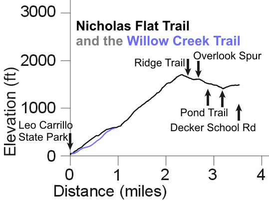
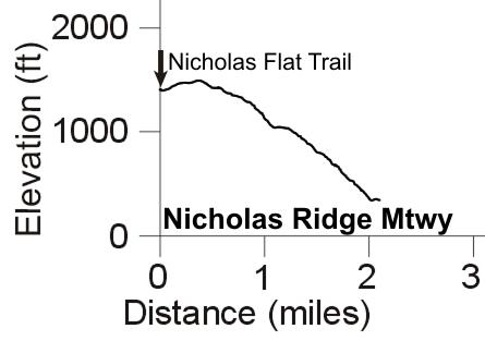
[3] Nicholas Flat Trail HO
|
|
Description This very popular trail has one end next to the parking area in Leo Carrillo State Park and the other end at the west end of Decker School Road. From Leo Carrillo, it starts with a long an fairly steep climb for about 2 miles, then crests and heads downhill. It crosses the Pond Trail 2/3 of a mile before reaching the Decker School Rd trailhead.
The trail on the Malibu side is quite open, rutted to various degrees, with low chaparral on the hills. Towards the top where it isn't quite a steep, the tread is much more even, but there are a few rocky steps, and the chaparral closes overhead to provide some nice shade. Being essentially a ridgeline trail, there are great views in three directions until the chaparral gets too tall to see over. But soon you start to descend to Nicholas Flat and can see the meadows and lake, with mountains a few miles to the north.
The Ocean Vista Trail heads up a little hill, 0.8 miles from the bottom, to give a good view of the coast and the park below. The slightly longer and less steep Willow Creek Trail meets this trail at the same spot. You may find that trail a little easier to get to the Ocean Vista Trail.
Download the GPS track
![]() to help you find your way.
to help you find your way.
|
Length (miles) |
3.5 |
|
Climb (feet) |
1770 |
|
Descent (feet) |
300 |
Trail Profile Back to the Top
 Description This trail
starts at the same place as the Nicholas Flat Trail in Leo Carrillo State Park,
but it goes around the bottom hill to the east. It meets the Nicholas Flat Trail
0.9 miles later where the Ocean Vista Trail starts. This trail is not quite
as steep as Nicholas Flat Trail and has views into an undeveloped canyon, so
it may be a preferable way to get to the Ocean Vista Trail. Also, because it
faces east, the noise of traffic on Mulholland is blocked. When combined with
the bottom of Nicholas Flat Trail, it makes a nice loop of less than 2 miles.
Description This trail
starts at the same place as the Nicholas Flat Trail in Leo Carrillo State Park,
but it goes around the bottom hill to the east. It meets the Nicholas Flat Trail
0.9 miles later where the Ocean Vista Trail starts. This trail is not quite
as steep as Nicholas Flat Trail and has views into an undeveloped canyon, so
it may be a preferable way to get to the Ocean Vista Trail. Also, because it
faces east, the noise of traffic on Mulholland is blocked. When combined with
the bottom of Nicholas Flat Trail, it makes a nice loop of less than 2 miles.
Download the GPS track
![]() to help you find your way.
to help you find your way.
|
Length (miles) |
0.9 |
|
Climb (feet) |
500 |
|
Descent (feet) |
20 |
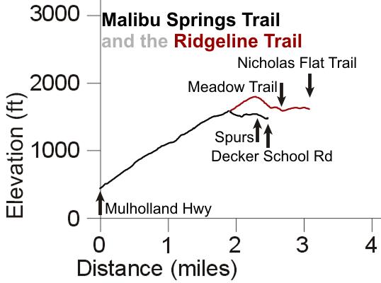
[5] Ridgeline Trail NB
 Description This trail
is basically an upward extension of the Malibu Springs Trail that connects to the Nicholas
Flat Trail. The elevation profile is shown with that for the Malibu
Springs Trail.
Description This trail
is basically an upward extension of the Malibu Springs Trail that connects to the Nicholas
Flat Trail. The elevation profile is shown with that for the Malibu
Springs Trail.
Download the GPS track
![]() to help you find your way.
to help you find your way.
|
Length (miles) |
1.2 |
|
Climb (feet) |
300 |
|
Descent (feet) |
300 |
[6, 7] Pond Trail, Meadow Trail NB
 Description This trail
starts at the Nicholas Flat Trail about 1/3 mile from the Decker School Rd trailhead.
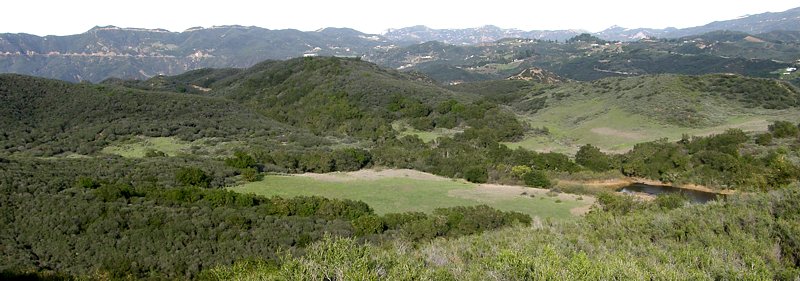
It bears south, through some marshes and a meadow next to a small year-round
lake. At the point where it turns 90-degrees right (north-west), there is a
spur trail that climbs up on the rocks that form a natural dam that contains
the lake. It's well worth taking this little spur - on hot days, it's cool with the lakewater
under the shade of oak trees that grow on the dam. And the south face of the
dam forms a pretty nifty cliff! Many people just hike to the dam for a picnic
or to watch the ducks for awhile before heading back.
Description This trail
starts at the Nicholas Flat Trail about 1/3 mile from the Decker School Rd trailhead.
It bears south, through some marshes and a meadow next to a small year-round
lake. At the point where it turns 90-degrees right (north-west), there is a
spur trail that climbs up on the rocks that form a natural dam that contains
the lake. It's well worth taking this little spur - on hot days, it's cool with the lakewater
under the shade of oak trees that grow on the dam. And the south face of the
dam forms a pretty nifty cliff! Many people just hike to the dam for a picnic
or to watch the ducks for awhile before heading back.
From the lake, the trail turns north-west, running along a small treed ridge next to the meadow. To the west of the Nicholas Flat Trail it becomes the Meadow Trail, skirting the north edge of another meadow before ending at the Ridgeline Trail.
Download the GPS track
![]() to help you find your way.
to help you find your way.
|
Length (miles) |
0.75 |
|
Climb (feet) |
240 (Starting at Nicholas Flat Trail and going to the Ridgeline Trail) |
|
Descent (feet) |
60 |
[8] Malibu Springs Trail to Nicholas
Flat
NB
![]() T2.5
T2.5
![]() to T4
to T4
![]()
|
Description This underappreciated trail is not used as much as it should be, perhaps because of the limited parking at the bottom which makes the trailhead easy to miss. The trail starts on Mulholland Hwy and winds up to Nicholas Flat with moderate steepness. It is almost directly across from the bottom end of the Grotto, and you'll see more and more of it as you climb. With some binoculars, you can see the trees and rocks below the Grotto and the Canyon View Trail behind.
The lower section of the trail is all that's left of an old, tree-lined forest road. It's very shaded here but has very little poison oak. About 40% of the way up, the forest gives way to waist-high chaparral. At the boundary between NPS land and Leo Carrillo State Park, you can bear left onto a section (AKA South Trail; 8a on the map above) to get to Decker School Road. There are two spurs that lead to Decker School Rd, about a quarter mile from the Nicholas Flat Trailhead. During tick season, they hang onto the tall grass that overgrows this trail, so watch out for them! Alternatively, head right on the Ridgeline Trail to continue climbing a little way, soon crossing the Meadow Trail and finally meeting the Nicholas Flat Trail.
Download the GPS track
![]() to help you find your way.
to help you find your way.
Technical Rating: Mostly NB
![]() T2.5
T2.5
![]() with some sections up to T4
with some sections up to T4
![]()
|
Length (miles) |
1.9 |
|
Climb (feet) |
1200 |
|
Descent (feet) |
30 |
Trail Profile Back to the Top
 Description This fireroad
heads east from the Nicholas Flat Trail where that trail turns west. It starts
by climbing slightly through a meadow, then turns south and downhill along
the ridge towards the ocean. It overlooks Decker Canyon Road to the east. It
ends at a private club at the bottom.
Description This fireroad
heads east from the Nicholas Flat Trail where that trail turns west. It starts
by climbing slightly through a meadow, then turns south and downhill along
the ridge towards the ocean. It overlooks Decker Canyon Road to the east. It
ends at a private club at the bottom.
Download the GPS track
![]() to help you find your way.
to help you find your way.
Technical Rating T1.5
![]()
|
Length (miles) |
2.1 |
|
Climb (feet) |
150 |
|
Descent (feet) |
1230 |
Trail Profile Back to the Top
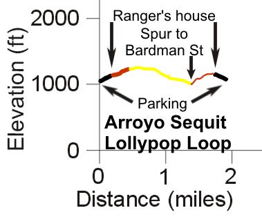
[10] The Arroyo Sequit Loop
Trail NB
![]() HO
HO
![]() T2.5
T2.5
![]()
 Description This short
loop of 2 miles provides probably the most tranquil hike in the area. On the
backside of the loop, the hills block the sound of traffic on Mulholland Hwy
and other roads so all you can hear is the water in the small creek alongside
the trail. From the parking area, the first 0.2 miles is a paved driveway (Mason
Rd) that leads to the ranger buildings. Turning left, the road becomes
dirt and quite rutted. There is a grassy area to the left of the road used to
set up telescopes to view the stars. About a third of a mile from the parking,
the Nature Trail segment of the loop starts on the right. It is somewhat rocky
and rutted at the beginning, but it is mostly quite firm, smooth and wide. About
a half mile from the parking, the trail heads downhill towards Reeder Canyon
Creek. In several places it the trail is washed out where the creek used to
flow under it. You'll have to jump down a couple of feet, then back up on the
other side, to cross. At one point you'll hear and then see a large waterfall
off to the left. At the end of the Nature Trail, the trail forks. A short spur
leads west (left) to Bardman St while the main trail heads up a steep switchback
section. If you look back while climbing back up to the start, you'll see some
huge white satellite dishes come into view. The loop ends with a short hike
across a meadow to the ranger buildings, then back down the driveway to the
parking.
Description This short
loop of 2 miles provides probably the most tranquil hike in the area. On the
backside of the loop, the hills block the sound of traffic on Mulholland Hwy
and other roads so all you can hear is the water in the small creek alongside
the trail. From the parking area, the first 0.2 miles is a paved driveway (Mason
Rd) that leads to the ranger buildings. Turning left, the road becomes
dirt and quite rutted. There is a grassy area to the left of the road used to
set up telescopes to view the stars. About a third of a mile from the parking,
the Nature Trail segment of the loop starts on the right. It is somewhat rocky
and rutted at the beginning, but it is mostly quite firm, smooth and wide. About
a half mile from the parking, the trail heads downhill towards Reeder Canyon
Creek. In several places it the trail is washed out where the creek used to
flow under it. You'll have to jump down a couple of feet, then back up on the
other side, to cross. At one point you'll hear and then see a large waterfall
off to the left. At the end of the Nature Trail, the trail forks. A short spur
leads west (left) to Bardman St while the main trail heads up a steep switchback
section. If you look back while climbing back up to the start, you'll see some
huge white satellite dishes come into view. The loop ends with a short hike
across a meadow to the ranger buildings, then back down the driveway to the
parking.
In addition to the loop trail, another trail cuts across the meadow from one side of the loop to the other. It is about a quarter mile long, with 100 ft of climbing when travelling from west to east, and only a few feet of descent.
Download the GPS track
![]() to help you find your way.
to help you find your way.
|
Length (miles) |
2.0 (starting at the parking area, hiking the loop and returning to the parking area) |
|
Climb (feet) |
400 |
|
Descent (feet) |
400 |
Trail Profile Back to the Top
|
This profile shows a "lollypop" loop (Mason Rd, the black segment, is traversed twice - once out and then back at the end). The direction of the loop is clockwise, heading left at the ranger's house from Mason Rd. The colors correspond to the colors on the topo map. |
|
This page was last updated April 1, 2025
|
|
Thanks for looking at Steve's guide to trails in Ventura County, the Santa Monica Mountains National Recreation Area (SMMNRA) and other locations. |
|