![]()
![]()
![]()
![]()
|
|
|
|
|
|
Encinal Fire Crew Trails |
||
|
||
|
||
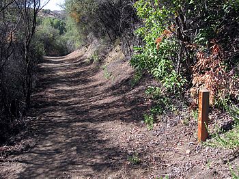
Across Encinal from the bottom of Clark Ranch Road is a facility for women prisoners who have volunteered for the fire service (Camp 13). These women train by building, maintaining and running on trails through the nearby brush. Their trails criss-cross the Backbone Trail on both sides of Encinal Canyon Road.
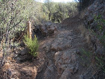
These trails are generally wide and well-used. The b2 and b3 sections of the Bonus Trail mostly contours around the base of the hill. In most places it has a firm tread and could be mistaken for the Backbone Trail above it. Most of the other trails either follow the fall line or climb steeply. They are steep to extremely steep, loose, rutted, rocky and slippery. The trails south of Encinal aren't as steep or rocky as those on the north side.
Even though these trails cross the Backbone Trail in a number of places, some of them are hard to see. Others are quite obvious, and many have wooden posts with the trail name. Even with these signs, there's some ambiguity of the names of some of the segments as outlined below.
The lower section of Bonus, Agony and the unsigned "w" trail would make good alternative routes to the backbone trail for a hiker who is looking for something a little more difficult and less travelled. These trails can be biked, but some sections are too steep to ride up so some hike-a-bike will be in order.
This area overlaps two other maps, Circle X Ranch to Encinal Canyon Road to the west and the Encinal Canyon Rd to Corral Canyon Backbone Trail area, including Zuma Ridge to the east.

Download the
GPS tracks ![]() to help you find your way. All trails are included in this GPX file.
to help you find your way. All trails are included in this GPX file.
|
Trail |
Length (feet) |
Technical Rating |
Climb (feet) |
Descent (feet) |
Notes |
|
BB (Backbone Trail) |
This trail is described in more detail on another page |
||||
|
Bonus Trail |
|
||||
|
B1 |
605 |
75 |
10 |
|
|
|
B2 |
1760 |
100 |
170 |
travelling clockwise |
|
|
B3 |
1350 |
130 |
35 |
travelling clockwise |
|
|
B4 |
340 |
70 |
0 |
travelling clockwise |
|
|
B5 |
1100 |
140 |
0 |
|
|
|
B6 |
820 |
0 |
250 |
This trail is nasty steep! Descending is treacherous! |
|
|
Martins Trail |
|
||||
|
m1 |
600 |
160 |
20 |
|
|
|
m2 |
840 |
65 |
100 |
east to west. This trail is narrower than most and crosses a steep hillside |
|
|
m3 |
365 |
0 |
70 |
east to west. This trail is narrower than most |
|
|
m4 |
840 |
110 |
0 |
|
|
|
m5 |
2100 |
85 |
100 |
south to north. This is a ridgeline trail that has some steep and loose sections. |
|
|
Commando Trail |
|
||||
|
c1 |
160 |
30 |
0 |
east to west |
|
|
c2 |
105 |
15 |
0 |
east to west |
|
|
c3 |
605 |
145 |
0 |
|
|
|
Agony Trail |
|
||||
|
a1 |
840 |
90 |
5 |
west to east |
|
|
a2 |
710 |
10 |
100 |
west to east |
|
|
a3 |
2300 |
60 |
150 |
west to east |
|
|
a4 |
1300 |
T5
|
220 |
10 |
north to south; nice eucalyptus grove at the north end and then has a very steep climb |
|
a5 |
1050 |
110 |
30 |
north to south |
|
|
Unsigned Trails |
|
||||
|
v |
1560 |
0 |
260 |
east to west. Not as well travelled as the others. This ridgeline trail has great views to the west, better than the Backbone Trail. Very overgrown at the bottom where it meets the Backbone; clamboring down a 10' bank to get back to the Backbone. |
|
|
w1 |
580 |
40 |
10 |
east to west |
|
|
w2 |
2100 |
70 |
230 |
east to west. Not as well used as the others. Starts steep down and a little loose, follows the contour, then a steeper climb out |
|
|
x |
1500 |
230 |
15 |
east to west |
|
|
y |
520 |
0 |
70 |
east to west. Not as well used as the others. |
|
|
z |
450 |
65 |
0 |
south to north. Starts with a steep uphill firebreak climb, continues briefly on a dirt road, then back to a trail |
|
|
|
|
This page was last updated December 4, 2008
|
|
Thanks for looking at Steve's guide to trails in Ventura County, the Santa Monica Mountains National Recreation Area (SMMNRA) and other locations. |
|