Trails of
Trippet Ranch Area
of Topanga State Park
- Videos
- Area Weather
- Official Website

Meadows
and oak trees through which the Musch Trail wanders
|
Trails of Trippet Ranch Area
of Topanga State Park |
||
|
||
|
||
Trippet Ranch is the main entrance and parking area for Topanga State Park. It has some beautiful oak groves and meadows, unlike the rest of Topanga State Park that is more about rock formations and chaparral. The Musch / Musch Meadows trails show off the best of the meadows and oak trees. The Santa Ynez Canyon Trail leads down to a shady canyon and a waterfall, just a short hike from a trailhead in Pacific Palisades.
The Backbone Trail runs through this area, starting at the west with Dead Horse Trail and continuing on Musch Trail. The scenery along this section of the Backbone is about as good as it gets!
All the singletrack trails around Trippet Ranch are closed to mountain bikes. Nevertheless, some great rides can be had to Parker Mesa Overlook to the south and Eagle Rock and Rogers Road to the east.
|
|
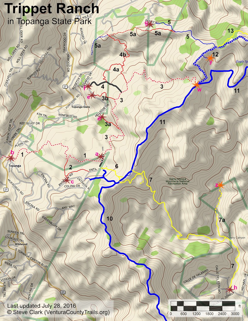
a. Main entrance at Trippet Ranch on Entrada Road. There is a fee
for parking here. Map
and directions
b. Dead Horse Trail trailhead on Entrada Road.
There is a fee for parking here. Map
and directions
c. On Entrada Road, at a spur to the 92 Trail.
There is parking for a few cars at the side of the road. Map
and directions
d. At the south end of Hillside Drive. There is
room for a few cars to park at the end of the road. Map
and directions
e. Access to the Prier Rd spur trail on Hillside
Drive. There is very little parking here. Map
and directions
f. On Hillside Drive at the Musch Ranch Access
Road. There is very little parking here. Map
and directions
g. At the top of Penny Road. The road isn't very
good so you may need a high clearance vehicle to get here. There is parking
at the side of the dirt road, or at the end of the road if you dare to drive
that far. Map
and directions (Check the directions if you use this map - Google may route
you along trails and roads that are closed to traffic)
h. On Verda
de la Montura in Pacific Palisades. There is parking on the street here. Map
and directions
 [1] Dead Horse Trail
Description This is a popular and very pretty segment of the Backbone Trail that leads up to Trippet Ranch. You can access it from Topanga Canyon Blvd, but since there is no parking there, it effectively starts at the lower Trippet parking lot ("b" in the Trailheads section). It winds mostly through tall and shady chaparral with occasional oak trees, but it also dips into an oak-lined canyon, then runs along the boundary between a large meadow and oak forest near the top. The tread is mostly firm but there are several rocky sections, and many steps.
There are a number of informal trails that criss-cross this area, most of which lead into the ajoining neighborhoods.
Download the GPS track ![]() to help you find your way.
to help you find your way.
|
Length (miles) |
1.3 |
|
Climb (feet) |
500 |
|
Descent (feet) |
100 |
Trail Profile Back to the Top

Description This peasant trail forks off from the Dead Horse Trail near the top, just before it enters a large meadow. The 92 Trail passes through oak groves and meadows, about half of each. The tread is firm and generally even. It leads to a small parking area at Trippet Ranch next to the parking attendant's booth.
Download the GPS track ![]() to help you find your way.
to help you find your way.
|
Length (miles) |
0.4 |
|
Climb (feet) |
100 (from Dead Horse Trail to Trippet parking) |
|
Descent (feet) |
50 |
[3] Musch Trail T2
Description The Musch Trail leads from a paved drive, a few hundred feet from the main Trippet Ranch parking area, to Eagle Junction. It is part of the Backbone Trail. About 80% traverses tall chaparral or oak forest, so it is very shady. The rest is meadow. The tread is mostly firm and broad singletrack, but with a few rocky sections and lots of steps. The slope is quite gentle near Trippet Ranch but gets quite a bit steeper about 2/3 of the way to the top. This beautiful trail is very popular, and for good reason! The photo below gives you a taste of what to expect.
 There are three spurs that lead down to Hillside Drive. The
closest to Trippet Ranch is the Musch-Hillside Drive Connector. It gets a lot
of use but is severly rutted and has some loose rocks, but is mostly pretty
firm. There is a small parking area at the bottom with room for several cars.
There are three spurs that lead down to Hillside Drive. The
closest to Trippet Ranch is the Musch-Hillside Drive Connector. It gets a lot
of use but is severly rutted and has some loose rocks, but is mostly pretty
firm. There is a small parking area at the bottom with room for several cars.
The next spur is Prier Road. The tread here is in pretty good shape. It leads through private property at the bottom and access to the park from Hillside Drive is permitted. There is very little parking on the street at the trailhead.
Musch Ranch Access Road provides access between Hillside Drive and the Musch Trail furthest from Trippet Ranch. This paved drive is described below.
Download the GPS track ![]() to help you find your way.
to help you find your way.
|
|
Musch Trail |
Hillside Drive Connector |
Prier Road |
|
Length (miles) |
2.1 |
0.1 |
0.25 |
|
Climb (feet) |
620 (From Trippet Ranch) |
0 (From Musch Trail) |
0 (From Musch Trail) |
|
Descent (feet) |
125 |
100 |
175 |
Trail Profile Back to the Top

Description This paved drive leads from from Hillside Drive up to the Musch Ranch campground and picnic area. There is a gate at the bottom so vehicular access is not possible. There is room for only one or two cars to park on the street at the bottom. For hikers and equestrians, the main interest will be that the Musch Meadows Trail ends about half way up this drive.
Download the GPS track ![]() to help you find your way.
to help you find your way.
Technical Rating T0
![]()
|
Length (miles) |
0.34 |
|
Climb (feet) |
200 (from Hillside Drive) |
|
Descent (feet) |
0 |
 [4a] Musch Meadows Trail
Description About 75% of this trail runs through meadow, hence the name. The rest is shady, either from oak trees or tall chaparral. It isn't as well used as the Musch Trail, probably because it's not as well known, but it's every bit as pretty and enjoyable! It starts about half way up the Musch Ranch Access Road and ends at the Musch Trail about 0.3 miles from the Trippet Ranch parking area. The tread is mostly firm and generaly pretty smooth.
Download the GPS track ![]() to help you find your way.
to help you find your way.
|
Length (miles) |
0.54 |
|
Climb (feet) |
200 (from Musch Ranch Access Road to Musch Trail) |
|
Descent (feet) |
100 |
Trail Profile Back to the Top

 Description This is another really
pretty trail. At the south end, the trail looks like a continuation of
the Musch Meadows Trail. It starts off very similar
to that trail and then winds its way more through tall chaparral. It is
well travelled, especially by equestrians who likely live in nearby communities.
The tread is mostly firm.
Description This is another really
pretty trail. At the south end, the trail looks like a continuation of
the Musch Meadows Trail. It starts off very similar
to that trail and then winds its way more through tall chaparral. It is
well travelled, especially by equestrians who likely live in nearby communities.
The tread is mostly firm.
I haven't made it quite to the north end of this trail, only going a little past the Cheney Ridge Trail. From the satellite photos, it's hard to tell if it connects directly to Callon Drive, or if the various forks all end at private property. In any event, the Cheney Ridge Trail provides a route to get to Eagle Rock, and then back to Trippet Ranch on the Eagle Rock/Eagle Springs Fireroad.
Download the GPS track ![]() to help you find your way.
to help you find your way.
|
Length (miles) |
0.5 |
|
Climb (feet) |
220 (from Musch Meadows Trail) |
|
Descent (feet) |
130 |
[5] Cheney Ranch Trail T3
 Description Cheney
Ranch Trail (photo at right) is an old fireroad that has narrowed down to a singletrack. At the
top, it starts at the Eagle Rock Fireroad, very close to Garapito Trail and
not so far from Eagle Rock. The tread is mostly rock, but not loose. It's a
fun trail for stong mountain bikers, and for hikers, it makes up part of
a large loop from Trippet Ranch to Eagle Rock and back. The bottom ends at Penny
Road. There is a very short, steep, rocky section about where the Cheney Ridge
Trail splits off that most mountain bikers will want to get off and walk.
Description Cheney
Ranch Trail (photo at right) is an old fireroad that has narrowed down to a singletrack. At the
top, it starts at the Eagle Rock Fireroad, very close to Garapito Trail and
not so far from Eagle Rock. The tread is mostly rock, but not loose. It's a
fun trail for stong mountain bikers, and for hikers, it makes up part of
a large loop from Trippet Ranch to Eagle Rock and back. The bottom ends at Penny
Road. There is a very short, steep, rocky section about where the Cheney Ridge
Trail splits off that most mountain bikers will want to get off and walk.

The Cheney Ridge Trail (photo to left) is a completely different story. Some of it is quite civilized, but a lot of it is very steep and/or rocky. Almost all moutain bikers will walk their bikes from the top where it joins Cheney Ranch Trail, to the Musch-Callon Drive Connector Trail. Strong hikers will find the trail not too difficult, but it is a little on the steep side for casual hikers. Even so, it is pretty, and provides a connection between the Musch-Callon Drive Connector Trail and Cheney Ranch Trail, thus enabling one to hike a loop from Trippet Ranch to Eagle Rock and back, not treading on any trail twice.
Download the GPS track ![]() to help you find your way.
to help you find your way.
|
|
Cheney Ranch Trail |
Cheney Ridge Trail |
|
Length (miles) |
0.66 |
0.9 |
|
Climb (feet) |
20 (from Eagle Rock Fireroad) |
40 (from Cheney Ranch Trail) |
|
Descent (feet) |
360 |
560 |
Trail Profile Back to the Top

Description This easy trail (a one-mile return trip with only 250 feet of climbing total) starts at the main Trippet Ranch parking area and meanders through oak groves and small meadows before crossing Eagle Springs Fireroad where chaparral predominates. A brochure is available at the start that provides descriptions for the numbered stations along the way.
Download the GPS track ![]() to help you find your way.
to help you find your way.
|
Length (miles) |
0.5, including the segment that connects to the Santa Ynez Canyon Trail |
|
Climb (feet) |
220 (from Trippet Ranch parking area) |
|
Descent (feet) |
30 |
[7] Santa Ynez Canyon Trail T4
 Description This popular
trail drops from the Eagle Springs Fireroad down to Verda de la Montura in Pacific
Palisades. There are two distinct and quite different sections of the trail.
The top half generally follows a ridgeline down to the canyon. The trail here
is moderately steep with a rutted but firm tread. There's not much shade. The
technical rating is T4
Description This popular
trail drops from the Eagle Springs Fireroad down to Verda de la Montura in Pacific
Palisades. There are two distinct and quite different sections of the trail.
The top half generally follows a ridgeline down to the canyon. The trail here
is moderately steep with a rutted but firm tread. There's not much shade. The
technical rating is T4
![]() for this section. Once in the canyon (photo to right), the slope is very gentle and most of the
trail is shaded by huge oak and sycamore trails. However, with the shade comes
poison oak just off the trail. The technical rating is T2
for this section. Once in the canyon (photo to right), the slope is very gentle and most of the
trail is shaded by huge oak and sycamore trails. However, with the shade comes
poison oak just off the trail. The technical rating is T2
![]() for this section of the trail.
for this section of the trail.

The Waterfall Trail (photo at left) starts about a half mile from the bottom of the Santa Ynez Canyon Trail. This is a fun trail for the more adventurous hiker. It starts off quite nicely, but after about a quarter mile, it becomes much harder to follow, crossing the stream back and forth, and even going up the stream bed in places. There is lots of poison oak encroaching on this trail, so keep a watch out for it.
Download the GPS track ![]() to help you find your way.
to help you find your way.
|
|
Santa Ynez Canyon Trail |
Waterfall Trail |
|
Length (miles) |
2.0 |
0.5 (to the waterfall) |
|
Climb (feet) |
50 (from Eagle Springs Fireroad) |
170 |
|
Descent (feet) |
880 |
50 |
Trail Profile Back to the Top

This page was last updated July 28, 2016
|
|
Thanks for looking at Steve's guide to trails in Ventura County, the Santa Monica Mountains National Recreation Area (SMMNRA) and other locations. |
|
 [2] 92 Trail