|
Trails of
Los
Robles Trail West Area
(Moorpark Rd to Pt
Mugu State Park)
|
|
|
|
|
| 
From the picnic table, looking south-west towards Sycamore
Canyon with the Channel Islands in the distance and Newbury Park
below.
|
Overview
The Los Robles Trail starts near Hampshire Road near the 101 Freeway
and ends at Potrero Road near Wendy Drive. The eastern part is 95%
fire road but adjoins some nice single tracks. The western section,
described here, is 95% single track and has some great views
of the city, and of Hidden Valley in a couple of spots. There
are several connecting trails so loops of different lengths can
be travelled. Out-and-backs are also fun. This is one of the most enjoyable
and popular areas for mountain bikers in the Conejo Valley.
When the trails are wet and muddy, the eastern part of Los
Robles West from Moorpark Road to Angel Vista sheds water well. Rosewood
Trail is nearly as good, but takes a little longer to dry enough to use.
The day after a rain, even a heavy one, you will find lots of people on this
trail, especially mountain bikers.

Geocaches in the area
Trailheads
a. The most popular is at the south end of Moorpark
Road at the east end of the trail.
Map
and directions.
b. There are a number of parking spaces and
a bathroom at the east end of this segment of Greenmeadow. Map
and directions.
c. On the east side of Greenmeadow, just north
of Kenwood Street, a path goes between the houses. Map
and directions.
d. At the south end of Spruce Hill Court. Map
and directions.
e. Near the south end of Regal Oak Court, south
of Lynn Rd, on the east side.
Map
and directions.
f. The south end of Felton St, south of Lynn
Rd. Map
and directions.
g. There is a large dirt parking area off of Potrero
road, about 1/2 miles east of Lynn Rd. Map
and directions.
h. At the south end of Wendy Dr, on the side
of Potrero Road. Map
and directions.
Suggested Rides and Hikes
This list was generated on January 22, 2006
Trails
[1]
Los Robles Trail West (AKA "Space Mountain")
| 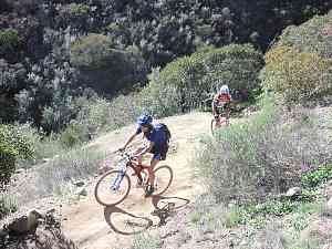 "Space Mountain" gets its name from the switchbacks
|
Description Starting at
the parking lot at the south end of Moorpark Road, the trail begins
as a fire road heading west. After about a half mile, at the top
of a short hill, the eastern half of this trail splits off towards
the south. Another hundred yards on, the fire road becomes Spring
Canyon Trail and Los Robles Trail West heads up the hill, fondly
known as Space Mountain, as a single track. Space Mountain starts
with a short steep climb, then settles into a gradual climb with
several sharp switchbacks. The trail is in good shape, but has a
lot of sharp rocks embedded in it and some occasional ruts. For
mountain bikers, Intermediate
riders will have to walk part of this and novices will walk most
of it. At the top of Space Mountain a traverse begins that has a
great view of the city below. About 3 miles from the parking lot
is a short, steep downhill section with two sharp switchbacks, just
before the trail crosses a private road. From here there is a gradual,
then steeper climb, to where the trail forks to the left. (To the
right is a very short connector to the top of the Rosewood Trail
right and down, and left to the picnic table at Angel Vista.) Going left at the fork, the trail heads down and
around a couple more switchbacks, then becomes very straight as
it runs along a fence. However, there are some very steep, rutted and
usually loose hills in this stretch, first up and then three downhill
stretches. Almost all mountain bikers walks parts of these uphills, whichever
direction they are travelling. The tread on these steep sections
is usually a little loose and slippery, presenting a hazard to hikers and mountain
bikers alike. Continuing west, you pass the Felton Street Connector and finallly
come to the parking area on Potrero Road, at the west end of the trail. A connector trail
to Sycamore Canyon is directly across the street.
From Moorpark Rd to the picnic table at Angel Vista, the soil is
quite sandy and the trail is well drained so it doesn't get muddy
during the rainy season. In the winter, people ride here a lot because
all other local trails are too muddy. However, west of the picnic
table, this trail is as muddy as anywhere else.
Download the GPS track  to help you
find your way.
to help you
find your way.
|
Length (miles)
|
6.0 |
|
Climb (feet)
|
Because of the steep hillsides,
the GPS track is not accurate enough to determine the amount of
climbing. However, the elevation gain from Moorpark Rd to Angel
Vista is 730', so expect about 1000' of climbing. |
|
Descent (feet)
|
Because of the steep hillsides,
the GPS track is not accurate enough to determine the amount of
climbing |
Trail Profile Back
to the Top

[2]
Rosewood Trail
|  Rosewood Trail has some switchbacks, too.
|
Description Rosewood Trail splits
off from Los Robles Trail at Angel Vista and ends at Lynn Road,
about one 1000 ft west of Ventu Park Rd. It is 100% single track
and, starting at the top, 99% downhill, not too steep, but with
lots of switchbacks. Its a real blast to ride down, but be careful
because there are a lot of people on it, particularly hikers, and
lots of blind corners to hide them. For climbing, it is about
the same steepness as Space Mountain. Being on the north face of
the hill, the bushes are always green, so it is pretty as well.
There is no parking at the very bottom on Lynn Road, but there
is parking and access on Regal Oak Court.
This is a very popular trail for people who
want a short hike to get to a great view.
Download the GPS track
to help you
find your way.
|
Length (miles)
|
1.8 from Lynn Rd; 1.6 from parking
on Regal Oak Court. |
|
Climb (feet)
|
20 (Starting at Los Robles Trail) |
|
Descent (feet)
|
800 |
|
Trail Profile Back
to the Top

 [3]
Spring Canyon Fire Road
[3]
Spring Canyon Fire Road
Description
About a half mile west of the parking
area on Moorpark Road, the Los Robles trail turns sharply left up
Space Mountain and becomes a single track. Meanwhile, the fire road
continues on as Spring Canyon Trail for nearly a mile. There are
some gentle climbs and descents and the road is in pretty good condition
so it is easy for novice riders, and people who like to ride fast, can.
Nevertheless, mountain bikers should be careful because there is quite a bit
of hiking and equestrian traffic on this trail. This trail is as part of a loop that goes
up Space Mountain and comes down either Rosewood or the Felton St
connector, connecting the two on Lynn Road.
Download the GPS track
to help you
find your way.
|
Length (miles)
|
0.9 |
|
Climb (feet)
|
120 |
|
Descent (feet)
|
140 |
|
Trail Profile Back
to the Top

[4]
Oak Creek Canyon Loop (AKA Whole Access Trail and "The Whoop-de-doos")
 Description
The Oak Creek Loop is a single track
shaped like an inverted "U," connected at the ends with
a short section of street and joining to Los Robles Trail at the top.
The two sides have very different personalities. The west side has
two trails separted by a small fence and mostly under a canopy of
huge oak trees. On one side is a nature walk,
and on the other side is a very tame biking and equestrian trail.
It climbs very genly over its length, except for the last few dozen
feet that is quite a bit steeper. This section is also known as
the Whole Access Trail because it can accommodate wheel chairs, and there is
a cable and plates with brail along the fence to guide blind people. The east side has rocky
patches, small ruts, sudden rises and dips, and tight corners. It
is fondly known as the Space Mountain whoop-de-doos. It's a blast
to ride down and the perfect way to end a ride in the region (nobody
ever rides up it - if you want to go down it again, ride up the
western leg of this loop). Note for hikers: If you take the
eastern leg, hike up it (north to south) so you can see oncoming mountain bikers!
Description
The Oak Creek Loop is a single track
shaped like an inverted "U," connected at the ends with
a short section of street and joining to Los Robles Trail at the top.
The two sides have very different personalities. The west side has
two trails separted by a small fence and mostly under a canopy of
huge oak trees. On one side is a nature walk,
and on the other side is a very tame biking and equestrian trail.
It climbs very genly over its length, except for the last few dozen
feet that is quite a bit steeper. This section is also known as
the Whole Access Trail because it can accommodate wheel chairs, and there is
a cable and plates with brail along the fence to guide blind people. The east side has rocky
patches, small ruts, sudden rises and dips, and tight corners. It
is fondly known as the Space Mountain whoop-de-doos. It's a blast
to ride down and the perfect way to end a ride in the region (nobody
ever rides up it - if you want to go down it again, ride up the
western leg of this loop). Note for hikers: If you take the
eastern leg, hike up it (north to south) so you can see oncoming mountain bikers!
Download the GPS track
to help you
find your way.
|
Length (miles)
|
0.66 |
|
Climb (feet)
|
80 |
|
Descent (feet)
|
100 |
|
Trail Profile Back
to the Top

 [5]
Greenmeadow Path, Cameron Center and Greenmeadow Bike Path
[5]
Greenmeadow Path, Cameron Center and Greenmeadow Bike Path
There is a little-known access to the base of Space Mountain from Greenmeadow
Drive in Newbury Park. The trailhead is two blocks south of Lynn Rd,
on the east side. It starts as a grassy corridor that goes between the houses
and ends at the Cameron Center at the golf course. The route heads right, along the paved
driveway until
it gets back to Greenmeadow where a paved bike path starts. Follow the bike
path to the end, a few hundred feet from the west leg of the Oak
Creek Canyon Loop Trail. This route can also be used to return to the Moorpark
trailhead from Newbury Park without having to cross over to the north side
of the freeway.
|
Length (miles)
|
1.5 |
|
Climb (feet)
|
130 |
|
Descent (feet)
|
90 |
|
Download the GPS track
to help you
find your way.
This page last updated January
4, 2015

