 |
Looking back down Long Canyon
|
|
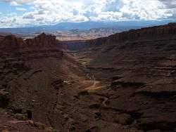 |
A dark exposure to show the clouds and La Sal Mountains.
|
|
 |
Zoomed in to for a better view of the La Sal Mountains and the fins between here and there.
|
|
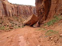 |
A small rock has fallen on the Long Canyon Road up towards Pucker Pass
|
|
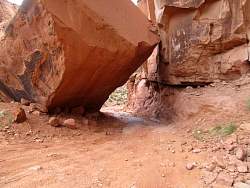 |
There's still enough room for jeeps to make it through, but it's pretty rocky underneath
|
|
 |
View from the balcony of the Visitors' Center in Dead Horse Point State Park
|
|
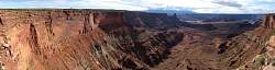 |
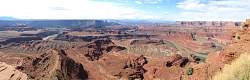
Panorama from the overlook near the Visitors' Center in Dead Horse Point State Park
|
|
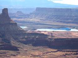 |
Zoomed in view of the potash evaporation ponds. I'll ride by those on the way back to Moab
|
|
 |
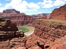
The Dead Horse Point Overlook has a stunning view of the Colorado River
|
|
 |
There's a boat in the river way down there!
|
|
 |
The view from Dead Horse Point overlook...
|
|
 |
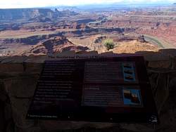
... and the plaque that describes how the landscape formed.
|
|
 |
Those people are much closer to the edge that I would be comfortable with!
|
|
 |
Another panorama from Dead Horse Point overlook. You can see Potash Road, on this side of the river, that I'll be taking to get back to Moab.
|
|
 |
A closer look at Potash Road
|
|
 |
You can also see Shafer Trail that comes down from the mesa and connects to Potash Road
|
|
 |
A more zoomed in view of Shafer Trail. You can see a couple of the switchbacks at the upper-left.
|
|
 |
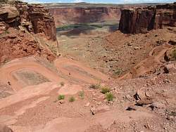
After a lot of riding, I got to the top of the switchback road that leads to Mineral Bottom.
|
|
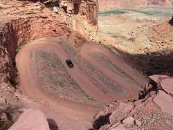 |
A look down the switchbacks. The road is broad and pretty smooth.
|
|
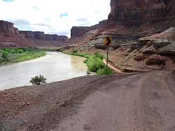 |
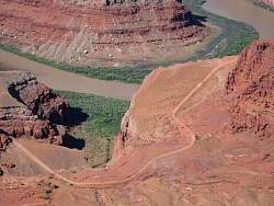
Mineral Bottom, beside the Colorado River
|
|
|
 |
A 180-degree panorama of the Colorado River at Mineral Bottom
|
|
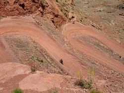 |
Mountain bikers riding up from Mineral Bottom
|
|
 |
There are lots of mountain bikers coming up!
|
|
 |
A Lexus going down
|
|
 |
The mountain bikers have ridden the White Rim Road all the way around from the Shafer Trail
|
|
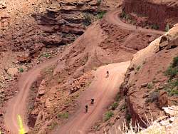 |
It took 4 days for them to ride all the way around, and now they're almost at the end of their trip! I hope their escort vehicles have lots of cold beer to celebrate!
|
|
 |
A lot more riding gets me to the Shafer Trail
|
|
 |
From this vantage point, you can see the top of the switchbacks that lead down to Potash Road (and also White Rim Road).
|
|
 |
Potash Road heads towards Moab where the weather doesn't look so good
|
|
 |
Potash Road from the bottom of the Shafer Trail
|
|
 |
View of the Colorado River from Potash Road. It was a much better view from Dead Horse Point which is somewhere above me at this point.
|
|
 |
The weather looks pretty dark towards Moab.
|
|
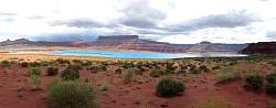 |
A panorama of a potash evaporation pond. They add color to the water to make it evaporate faster.
|
|
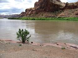 |
The Colorado River from Gold Bar on Hwy 279, on the way back to Moab
|
|
 |
Giant fossilized sand dunes seen from Gold Bar
|
|
