|
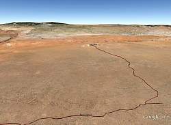
Google Earth view of the Vermillion Cliffs National Monument, looking north-east. My route is the dark brown line, starting down House Rock Road on the left from Hwy 89 in Utah. In the background is Lake Powell.
"The Wave" rock formation is shown as a point of reference. Although Hwy 89 is in Utah, the National Monument is entirely in Arizona.
|
|
 |
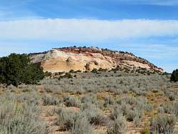
A closer view of the top of the mesa of the Vermillion Cliffs National Monument, called Sand Hills. The view is looking north-east. Sand Hills is relatively lacking in large features and is mostly gentle, sandy hills.
|
|
 |
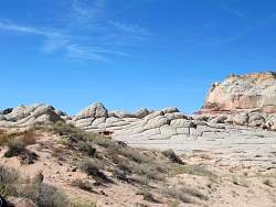
There are some largish rock outcroppings at White Pocket.
|
|
 |
At the north end of House Rock Road, near to Hwy 89.
|
|
|
 |
A closer view of the rock formation seen in the background of the previous photo.
|
|
 |
The road on Sand Hills that heads north to White Pocket. The entire route looks very much like this.
|
|
 |
As I get close to White Pocket, I spy this formation near the road, the first I've seen.
|
|
 |
When I get even closer, I start to see some larger formations.
|
|
|
|
|
 |
The trail to the main area of White Pocket is only a few hundred yards long
|
|
|
|
 |
White Pocket, or at least part of it
|
|
 |
It looks like dried, cracked mud, but really it's rock and very solid.
|
|
|
|
|
|
|
|
 |
Zoomed in, this formation reminds me of a race track oval
|
|
|
|
|
|
|
|
|
|
 |
This small area, about 20' across, reminds me of The Wave
|
|
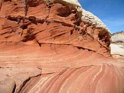 |
The same area as the previous photo, taken from the other end
|
|
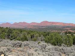 |
Back on House Rock Road, you get an increasingly good view of the cliffs on the east side of House Rock Valley (and the west edge of the Vermillion Cliffs National Monument) as you travel north.
|
|
|
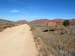 |
I decided to drive to the top of the Winter Road to see if I could look down on the National Monument to the east.
|
|
 |
The beginning of Winter Road
|
|
 |
Looking back at the National Monument from Winter Road
|
|