Click on an image to see it full size.
 |
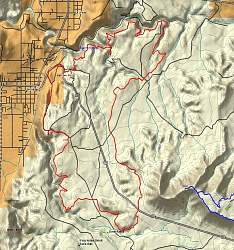
Overview of the trails we rode, from left to right (in red): Broken Mesa, Church Rock, Hurricane Cliffs and Little Creek Mesa. The Gooseberry Mesa Trail is shown in blue from an earlier trip.
|
|
 |
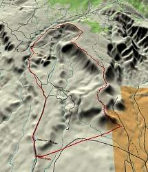
3-D overview of the trails we rode, from left to right (in red): Broken Mesa, Church Rock, Hurricane Cliffs and Little Creek Mesa. The Gooseberry Mesa Trail is shown in blue from an earlier trip.
|
|
 |
Topographical view of the Broken Mesa ride.
|
|
 |
3D view of the Broken Mesa ride, from the south.
|
|
 |
Elevation profile of the Broken Mesa ride.
|
|
 |
Topographical view of the Hurricane Cliffs trails, in red. Part of the Gooseberry Mesa Trail is seen in blue.
|
|
 |
3D view of the Hurricane Cliffs trails, in red, from the west. Part of the Gooseberry Mesa Trail is seen in blue in the background.
|
|
 |
Elevation profile of the Hurricane Cliffs ride.
|
|
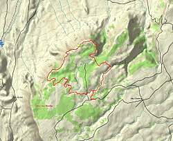 |
Topographical view of the Little Creek Mesa trail.
|
|
 |
3D view of the Little Creek Mesa Trail from the south-west. The Gooseberry Mesa trail can be seen in the top right corner, in blue.
|
|
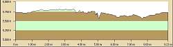 |
Elevation profile of the Little Creek Mesa ride.
|
|
|