![]()
![]()
![]()
![]()
![]()
|
|
|
|
|
|
|
Details for |
|||
The Rocky Peak Area in Simi Valley |
|||
| [1]
Rocky Peak Fire Road
|
|
|
Description |
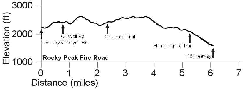
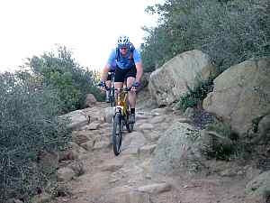
The Rocky Peak Fire Road runs generally north and south, from the 118 freeway in the south, past Chumash single track and to Las Llajas Canyon Rd, with a great view of Simi Valley below. Most of it is very steep and a little rutted and rocky, but fairly firm except for a few sandy patches. Nevertheless, this trail should only be attempted by experienced riders.There is no shade and in the summertime this area is impossibly hot. |
|
Length (miles) |
6.1 |
|
Climb (feet) |
1300 |
|
Descent (feet) |
1900 Back to the Top |
Trail Profile
| [2]
Chumash Single Track |
|||
|
If you think this trail is steep, see how it compares to other steep trails. It's technical at the top! |
|||
|
Length (miles) |
2.7 |
|
|
|
Climb (feet) |
1550 |
|
|
|
Descent (feet) |
450 |
|
|
Trail Profile Back to the Top

| [3] Hummingbird Single Track
|
||
|
|
||
|
Length (miles) |
2.0 | |
|
Climb (feet) |
170 | |
|
Descent (feet) |
1130 Back to the Top |
|
Trail Profile

Trail Profile Back to the Top
Trail Profile Back to the Top
This page last updated on June 10, 2007
|
|
Thanks for looking at Steve's guide to trails in Ventura County, the Santa Monica Mountains National Recreation Area (SMMNRA) and other locations. |
|

 Description:
The Chumash trail starts at the
end of Flanagan Drive in eastern Simi Valley and ends at the Rocky
Peak fire road about 1000 feet about it. It has a consistant, fairly
steep grade to it and some rocks and ruts, with a few spots where
getting off and walking is in order, whether going up or down, but
there are no really loose spots.. This trail is for experienced
riders only, but those with the ability will have a blast in either
direction!
Description:
The Chumash trail starts at the
end of Flanagan Drive in eastern Simi Valley and ends at the Rocky
Peak fire road about 1000 feet about it. It has a consistant, fairly
steep grade to it and some rocks and ruts, with a few spots where
getting off and walking is in order, whether going up or down, but
there are no really loose spots.. This trail is for experienced
riders only, but those with the ability will have a blast in either
direction!
 Description:
The Hummingbird trail starts at the Rocky Peak
fire road and descends about 1000 feet to Kuehner Drive. It has
many very steep sections with tight switchback corners and is suitable
for advanced riders only. The correct direction to ride this
trail is down. From the bottom of Hummingbird you can take dirt
roads to the bottom of Chumash Trail, or the street to the south
end of Rocky Peak Fire Road.
Description:
The Hummingbird trail starts at the Rocky Peak
fire road and descends about 1000 feet to Kuehner Drive. It has
many very steep sections with tight switchback corners and is suitable
for advanced riders only. The correct direction to ride this
trail is down. From the bottom of Hummingbird you can take dirt
roads to the bottom of Chumash Trail, or the street to the south
end of Rocky Peak Fire Road. Description:
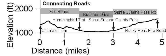
Utility and Fire Roads: You
can get from the bottom of Chumash to the bottom of Hummingbird
on back roads, 95% of which are dirt. There are a number of roads
in this area, so it's best to go with someone who knows the way.
Description:
Utility and Fire Roads: You
can get from the bottom of Chumash to the bottom of Hummingbird
on back roads, 95% of which are dirt. There are a number of roads
in this area, so it's best to go with someone who knows the way. Description:
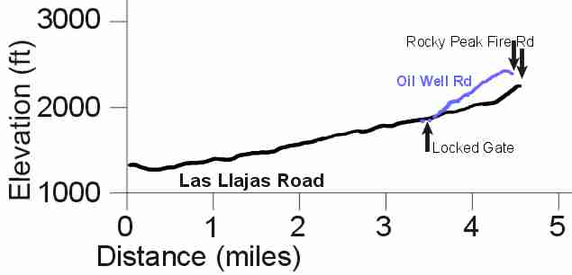
Las
Llajas Canyon Road starts at Evening Sky Drive and heads north.
It apparently used to be paved, as shown by the occasional patch
of pavement that still exists, but it is mostly dirt with a few
sandy patches. It climbs gently along the valley floor, winding
under frequent oak trees. This is a very pleasant ride for beginners.
3.4 miles in there is a branch to the right, Oil Well Rd, and a
locked gate if you continue straight. Oil Well Rd is a dirt road
that starts off by dipping slightly, then it climbs to an old oil
well, then climbs very steeply to meet Rocky Peak Fireroad. The
road is in good shape, firm and quite smooth, but the steepness
makes it most suitable for strong riders. The upper sections of
Oil Well Rd and the ajoining areas of Rocky Peak Fireroad are part
of an active ranch so you may come across a herd of cattle
on the road or near it.
Description:
Las
Llajas Canyon Road starts at Evening Sky Drive and heads north.
It apparently used to be paved, as shown by the occasional patch
of pavement that still exists, but it is mostly dirt with a few
sandy patches. It climbs gently along the valley floor, winding
under frequent oak trees. This is a very pleasant ride for beginners.
3.4 miles in there is a branch to the right, Oil Well Rd, and a
locked gate if you continue straight. Oil Well Rd is a dirt road
that starts off by dipping slightly, then it climbs to an old oil
well, then climbs very steeply to meet Rocky Peak Fireroad. The
road is in good shape, firm and quite smooth, but the steepness
makes it most suitable for strong riders. The upper sections of
Oil Well Rd and the ajoining areas of Rocky Peak Fireroad are part
of an active ranch so you may come across a herd of cattle
on the road or near it.