 |
The Los Liones Trail in light blue. The dark blue line is East Topanga Fireroad in Topanga State Park
|
|
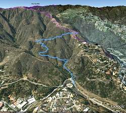 |
Google Earth view of the trail, looking north. The Los Liones Trail is shown in light blue. Purple is the East Topanga Fireroad and other trails in Topanga State Park.
|
|
 |
The trailhead on Los Liones Drive
|
|
 |
There is lots of shade and green on this trail
|
|
 |
The trail rolls up and down and undulates side to side
|
|
|
|
|
|
 |
This bright green ivy is growing everywhere
|
|
 |
Trees are covered with the vine
|
|
|
|
|
|
|
 |
Where the Los Liones Trail intersects with East Topanga Fireroad
|
|
 |
The top of Los Liones Trail as we're about to head back down
|
|
|
|
 |
Even though we're going down the trail, there are some little climbs
|
|
|
 |
Back at the bottom
|
|
 |
This bridge leads to one of the parking areas next to the street
|
|
|
|


